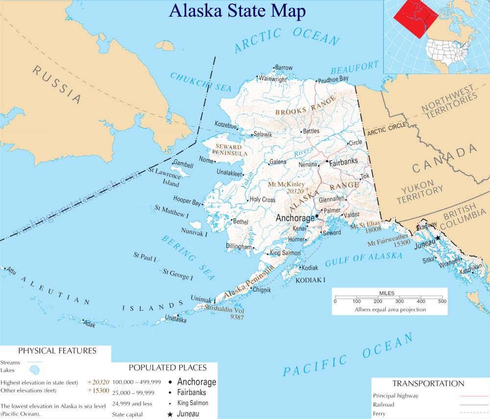
A large detailed map of Alaska State
This is a large, detailed map of Alaska. There are links to many Alaska localities below.
View our Alaska State county map
from the National Atlas of the United States
United States Department of the Interior
Alaska State Map
Explore Alaska with an interactive map featuring Street View, satellite and terrain views. Live weather, local news and location details for Alaska — plus links to detailed street maps for 357 cities and towns across the state.
Map search is available for a limited number of queries per session to manage costs. Be specific — search precisely for best results.
| State | Alaska (AK) |
| Capital | Juneau |
| Largest City | Anchorage |
| Country | United States |
| Latitude | 61.5008 |
| Longitude | -150.1121 |
| Population | 733,391 |
| Cities & Towns | 357 |
About Alaska
Alaska's vast expanse unfolds in a breathtaking tapestry of wild grandeur. Its interior, a rolling wilderness of boreal forests and tundra, is bisected by mighty rivers that carve their paths towards the sea, their waters teeming with life. Towering mountain ranges, their peaks often cloaked in perpetual snow, dominate the skyline, feeding glaciers that calve into pristine fjords along the dramatic coastline. This immense land is punctuated by numerous national and state parks, safeguarding ancient forests, volcanic landscapes, and the unparalleled beauty of its natural landmarks, all touched by a unique, ethereal light.
The human story of Alaska is deeply interwoven with its formidable environment, a narrative shaped by resilience and adaptation. Indigenous peoples have called this land home for millennia, developing profound connections to its rhythms and resources, their ancestral presence a silent testament to enduring traditions. European explorers and traders later arrived, drawn by the promise of riches and the allure of the unknown, gradually establishing a presence that would forever alter the course of Alaska's development. Through periods of territorial governance and a fierce drive for self-determination, Alaska eventually joined the United States, forging its modern identity as a frontier state.
The economy of Alaska is as diverse as its landscapes, driven by the abundant natural resources that define its character. Energy production, particularly oil and gas, forms a significant pillar, fueling industries and providing essential services. Fishing and seafood processing remain vital, supporting coastal communities and contributing to global markets. Beyond these primary sectors, Alaska also boasts a growing technology industry, a robust tourism sector that draws visitors from around the globe to witness its wonders, and a network of service industries that sustain its dispersed population.
The spirit of Alaska is one of independent character and deep connection to the outdoors, a culture that celebrates both tradition and innovation. While professional sporting leagues may not have a direct presence, the passion for athletic pursuits is undeniable, with strong community-based teams and a deep appreciation for outdoor recreation. Annual events, from dog sled races to cultural festivals, mark the changing seasons and bring communities together, celebrating the unique heritage of Alaska. The cuisine often reflects the bounty of the land and sea, featuring fresh seafood and game, prepared with a straightforward, hearty approach that mirrors the daily life of its people.
Alaska City and Town Maps
A
B
C
D
E
F
G
H
I
J
K
L
M
N
O
P
R
S
T
U
W
Y
Alaska Maps — Interactive Map, Street View, Weather & News
This page provides an interactive Google map of Alaska (AK) with Street View, satellite and terrain views, alongside links to detailed street maps for 357 cities and towns across the state. The state capital is Juneau and the largest city is Anchorage, with a state population of approximately 733,391.
Each city and town map page includes an embedded street and satellite map. Live weather where available combines National Weather Service forecasts with Open-Meteo graphical data including hourly and 7-day outlooks. Local and world news, Wikipedia location summaries, and precise GPS coordinates are included where available.
Location data is sourced from the USGS GNIS database and verified by coordinates, not name matching alone.