A large detailed map of Connecticut State
This is a large, detailed map of Connecticut. There are links to many Connecticut localities below. Our website format reduces the display size for uniformity. Here is a link to the full-size image that is more easily readable.
View our Connecticut State county map
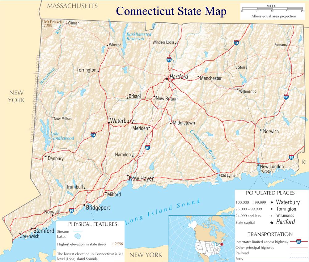
from the National Atlas of the United States
United States Department of the Interior
Connecticut State Map
Explore Connecticut with an interactive map featuring Street View, satellite and terrain views. Live weather, local news and location details for Connecticut — plus links to detailed street maps for 219 cities and towns across the state.
Map search is available for a limited number of queries per session to manage costs. Be specific — search precisely for best results.
| State | Connecticut (CT) |
| Capital | Hartford |
| Largest City | Bridgeport |
| Country | United States |
| Latitude | 41.597782 |
| Longitude | -72.755371 |
| Population | 3,605,944 |
| Cities & Towns | 219 |
Connecticut stretches from the gray, restless expanse of the Long Island Sound to the shadowed ridges of the Berkshires, defined by a landscape that feels perpetually caught between the sea and the forest. The Connecticut River bisects the land, a long, arterial vein that has dictated the flow of life for centuries, carving through a terrain of ancient, glacier-scraped rock and fertile floodplains. In the autumn, the air grows thin and sharp, carrying a scent of damp leaves and chimney smoke that settles low over the stone walls snaking through second-growth woods. These walls, silent remnants of a time when the land was cleared for pasture, now serve as anchors for the encroaching timber, mapping a geography where the coastal humidity of the south slowly surrenders to the bracing, granite-hearted chill of the north.
Indigenous nations, including the Pequot and Mohegan, held these river valleys and coastal estuaries long before the first timber-framed houses rose to meet the Atlantic winds. European settlers arrived to organize the wilderness into parishes and town greens, establishing a rigid, orderly society that nonetheless grappled with the harsh realities of the frontier. The formative years of Connecticut were marked by a defiant spirit of self-governance, a stubborn insistence on local autonomy that eventually helped define the broader American experiment. Today, the remnants of that colonial period remain etched into the architecture, where the spare, functional geometry of a saltbox house stands in quiet contrast to the imposing, heavy-set brick of later Federal-period estates, each structure holding the weight of centuries of adaptation and survival.
Economic life in Connecticut has always been a cycle of transformation, shifting from the early reliance on the river-mouth shipbuilding that fueled global trade to the frantic, steam-driven ingenuity of the industrial mill towns. Where water once powered looms and hammers, the state now focuses on complex manufacturing, high-end insurance, and the quiet precision of aerospace engineering. Agriculture has retreated from the rocky soil of the interior, though the shade-grown tobacco fields still stretch out in the river valley, their broad leaves shimmering under protective netting like ghost-white sails. It is a place that understands the necessity of industry, where the rhythmic clatter of long-gone machines has been replaced by the intellectual labor of laboratories and offices, yet the ghost of the craftsman remains in the state’s lingering devotion to the high-quality product.
Cultural identity here is a matter of quiet intersections, where the collegiate intensity of elite institutions brushes against the blue-collar pragmatism of the neighborhood pub. The pace of life is dictated by the seasons, from the frantic energy of a local basketball game in a drafty gymnasium to the hushed, library-bound silence of a rainy afternoon in a suburban study. Literature and music have long thrived in this environment, nourished by the isolation of the woods and the proximity to the intellectual centers of the coast. People here favor a certain reserve, a way of speaking that is direct and unadorned, reflecting a life lived in the shadow of stone and the reach of the tide. As dusk settles, the light turns a bruised, metallic violet over the salt marshes, signaling the end of another day in a state that demands a steady, deliberate attention to the ground beneath one's feet.
Connecticut City and Town Maps
B
C
D
G
L
M
N
O
P
R
S
T
W
Connecticut Maps — Interactive Map, Street View, Weather & News
This page provides an interactive Google map of Connecticut (CT) with Street View, satellite and terrain views, alongside links to detailed street maps for 219 cities and towns across the state. The state capital is Hartford and the largest city is Bridgeport, with a state population of approximately 3,605,944.
Each city and town map page includes an embedded street and satellite map. Live weather where available combines National Weather Service forecasts with Open-Meteo graphical data including hourly and 7-day outlooks. Local and world news, Wikipedia location summaries, and precise GPS coordinates are included where available.
Location data is sourced from the USGS GNIS database and verified by coordinates, not name matching alone.
