A large detailed map of Georgia State
This is a large, detailed map of Georgia. There are links to many Georgia localities below. Our website format reduces the display size for uniformity. Here is a link to the full-size image that is more easily readable.
View our Georgia State county map
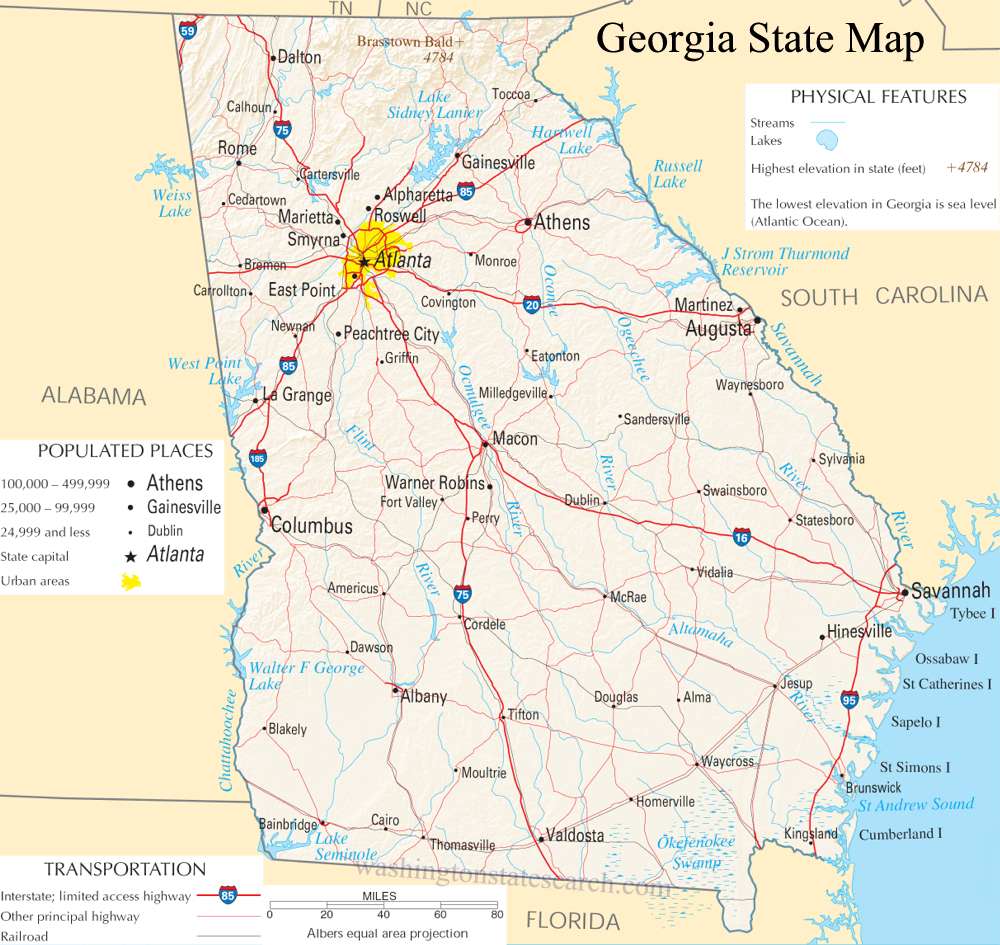
from the National Atlas of the United States
United States Department of the Interior
Georgia State Map
Explore Georgia with an interactive map featuring Street View, satellite and terrain views. Live weather, local news and location details for Georgia — plus links to detailed street maps for 712 cities and towns across the state.
Map search is available for a limited number of queries per session to manage costs. Be specific — search precisely for best results.
| State | Georgia (GA) |
| Capital | Atlanta |
| Largest City | Atlanta |
| Country | United States |
| Latitude | 33.040619 |
| Longitude | -83.643074 |
| Population | 10,711,908 |
| Cities & Towns | 712 |
Georgia possesses a physical geography that descends in a slow, deliberate cadence from the jagged granite spines of the Blue Ridge mountains down to the soft, shifting margins of the Atlantic. In the north, the terrain is defined by steep ridges and deep, cool hollows where the air stays heavy with the scent of damp moss and hemlock. As one travels southward, the land relents into the red-clay piedmont, a landscape of iron-rich soil that clings to the boots of any traveler who wanders off the pavement. This middle ground eventually gives way to the flat, wide expanse of the coastal plain, where the water table rises to meet the roots of longleaf pine and the sprawling, tangled vines of kudzu that reclaim abandoned fences in a slow, green tide. At dusk, the light in these low-country reaches thins into a pale, bruised violet, catching the salt-mist that rolls off the marshes and turning the horizon into a blurred seam between the earth and the darkening sky.
Georgia traces its human timeline back to the Muskogean and Iroquoian peoples who managed these forests with fire and wisdom long before the first colonial charters were drafted in distant offices. The arrival of European settlers disrupted these ancient rhythms, establishing a frontier that functioned as a defensive buffer against imperial rivals. Through the subsequent centuries, the state became a crucible for the most difficult questions of the American experience, marked by the brutal labor systems of the plantation era and the subsequent, agonizing shifts of the post-war reconstruction. These formative episodes defined the social architecture of the state, leaving behind a legacy of courthouse squares where the architecture of the nineteenth century still dictates the pace of the afternoon. There is a particular weight to the silence in these town centers when the heat of the day reaches its peak, a stillness that seems to hold the memory of every argument and resolution that has transpired on the shaded benches.
Economic life across the state has transitioned from a singular reliance on the fiber of the cotton boll to a diverse engine of logistics, aviation, and high-tech industry. The agricultural tradition persists, though it has evolved into a modern enterprise that harvests pecans, peaches, and Vidalia onions from the sandy soil of the interior. Historically, the labor of the land was the primary measure of value, but today the state serves as a central clearinghouse for international commerce, moving goods from the deep-water harbor on the coast to the rest of the continent. This shift has not erased the connection to the earth; even in the middle of a bustling logistics hub, one can see the persistence of the seasonal cycle in the way the local markets fill with the specific, fleeting bounty of the harvest. It is a place where the infrastructure of the future is built directly atop the deep, stubborn furrows of the past, creating a friction that defines the modern character of Georgia.
Cultural expression here is a layered dialogue between the formal traditions of the academy and the raw, kinetic energy of gospel, blues, and southern hip-hop. The voice of the state is often found in the long, lyrical sentence that prioritizes cadence and character over simple brevity, a style that mirrors the humid, expansive pace of life in the coastal islands and the interior forests. Sports occupy a position of near-sacred importance, with collegiate rivalries acting as the primary calendar by which many citizens mark the passage of the year, transforming autumn Saturdays into collective rituals. Food remains a vital language of hospitality, where the preparation of a simple meal—a pot of greens, a pan of cornbread, or a slow-cooked brisket—is treated with the same gravity as a civic duty. Whether standing in a crowded stadium or sitting on a quiet porch while the cicadas begin their rhythmic, electric hum, there is a sense of belonging to a place that demands to be known on its own terms, through its own stories, and in its own time.
Georgia City and Town Maps
A
B
C
D
E
F
G
H
I
J
K
L
M
N
O
P
R
S
T
U
V
W
Y
Georgia Maps — Interactive Map, Street View, Weather & News
This page provides an interactive Google map of Georgia (GA) with Street View, satellite and terrain views, alongside links to detailed street maps for 712 cities and towns across the state. The state capital is Atlanta and the largest city is Atlanta, with a state population of approximately 10,711,908.
Each city and town map page includes an embedded street and satellite map. Live weather where available combines National Weather Service forecasts with Open-Meteo graphical data including hourly and 7-day outlooks. Local and world news, Wikipedia location summaries, and precise GPS coordinates are included where available.
Location data is sourced from the USGS GNIS database and verified by coordinates, not name matching alone.
