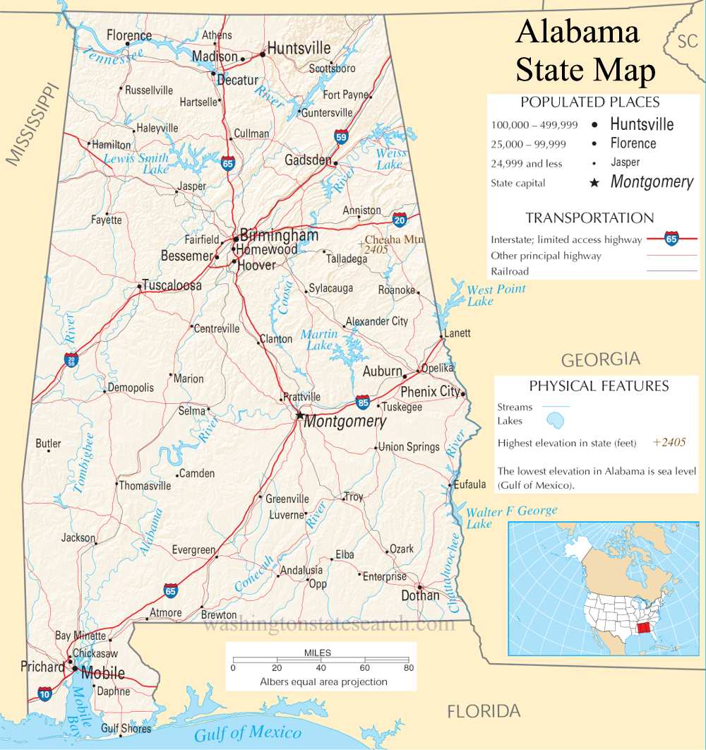
A large detailed map of Alabama State
This is a large, detailed map of Alabama. There are links to many Alabama localities below.
View our Alabama State county map
from the National Atlas of the United States
United States Department of the Interior
Alabama State Map
Explore Alabama with an interactive map featuring Street View, satellite and terrain views. Live weather, local news and location details for Alabama — plus links to detailed street maps for 508 cities and towns across the state.
Map search is available for a limited number of queries per session to manage costs. Be specific — search precisely for best results.
| State | Alabama (AL) |
| Capital | Montgomery |
| Largest City | Huntsville |
| Country | United States |
| Latitude | 32.8919 |
| Longitude | -86.7688 |
| Population | 5,024,279 |
| Cities & Towns | 508 |
About Alabama
Alabama unfolds with a varied and generous landscape, stretching from the gentle slopes of the Appalachian foothills in the north to the sandy shores of the Gulf Coast in the south. Major rivers like the Tennessee and the Alabama carve through its heart, nurturing fertile plains perfect for agriculture and providing vital waterways for transport. The climate here is warm and humid, fostering lush forests and vibrant ecosystems that support a rich array of flora and fauna. Numerous state parks offer protected havens, showcasing the natural beauty of places like the Dismals Canyon or the vastness of the Sipsey Wilderness. The land itself feels ancient and enduring, a tapestry woven with the greens of pine and oak, the blues of winding rivers, and the golden hues of sun-drenched fields.
The human story of Alabama is a deep and complex one, marked by the enduring presence of Native American peoples for millennia before European explorers arrived. Early settlements, driven by the promise of fertile land and abundant resources, gradually shaped the developing territory. Alabama officially joined the United States as the 22nd state, a pivotal moment in its journey toward becoming a distinct part of the American fabric. Through periods of profound change and challenge, the state's identity has been forged by the resilience and spirit of its diverse inhabitants, leading to the vibrant and multifaceted Alabama we know today.
The economy of Alabama is a robust blend of tradition and innovation, with agriculture remaining a cornerstone, particularly in the production of cotton, soybeans, and poultry. Manufacturing plays a significant role, with a strong presence in automotive assembly, aerospace, and machinery, contributing to the state's industrial might. Energy production, including coal and natural gas, also fuels its growth, while a burgeoning technology sector is steadily gaining traction in its major urban centers. Tourism thrives along the Gulf Coast and in its historic cities, drawing visitors to its beaches, cultural attractions, and natural wonders, all supporting a dynamic service industry.
Alabama's cultural identity resonates with a strong sense of heritage, deeply influenced by its Southern roots and a vibrant musical tradition. The state is a passionate supporter of sports, with college football holding a particularly revered place in the hearts of its residents, alongside thriving professional teams. Annual events, from lively festivals celebrating local harvest to significant cultural gatherings, punctuate the calendar, offering glimpses into the state's unique character. The cuisine of Alabama is a delicious exploration of Southern comfort food, featuring classic dishes that are both hearty and flavorful, embodying the warmth and hospitality of its people.
Alabama City and Town Maps
A
B
C
D
E
F
G
H
I
J
L
M
N
O
P
R
S
T
U
V
W
Y
Alabama Maps — Interactive Map, Street View, Weather & News
This page provides an interactive Google map of Alabama (AL) with Street View, satellite and terrain views, alongside links to detailed street maps for 508 cities and towns across the state. The state capital is Montgomery and the largest city is Huntsville, with a state population of approximately 5,024,279.
Each city and town map page includes an embedded street and satellite map. Live weather where available combines National Weather Service forecasts with Open-Meteo graphical data including hourly and 7-day outlooks. Local and world news, Wikipedia location summaries, and precise GPS coordinates are included where available.
Location data is sourced from the USGS GNIS database and verified by coordinates, not name matching alone.