A large detailed map of Alabama State Counties
Explore Alabama with an interactive map featuring Street View, satellite and terrain views. Browse all 67 counties of Alabama below, with links to every city and town map page. Live weather and local news are included on every location page.
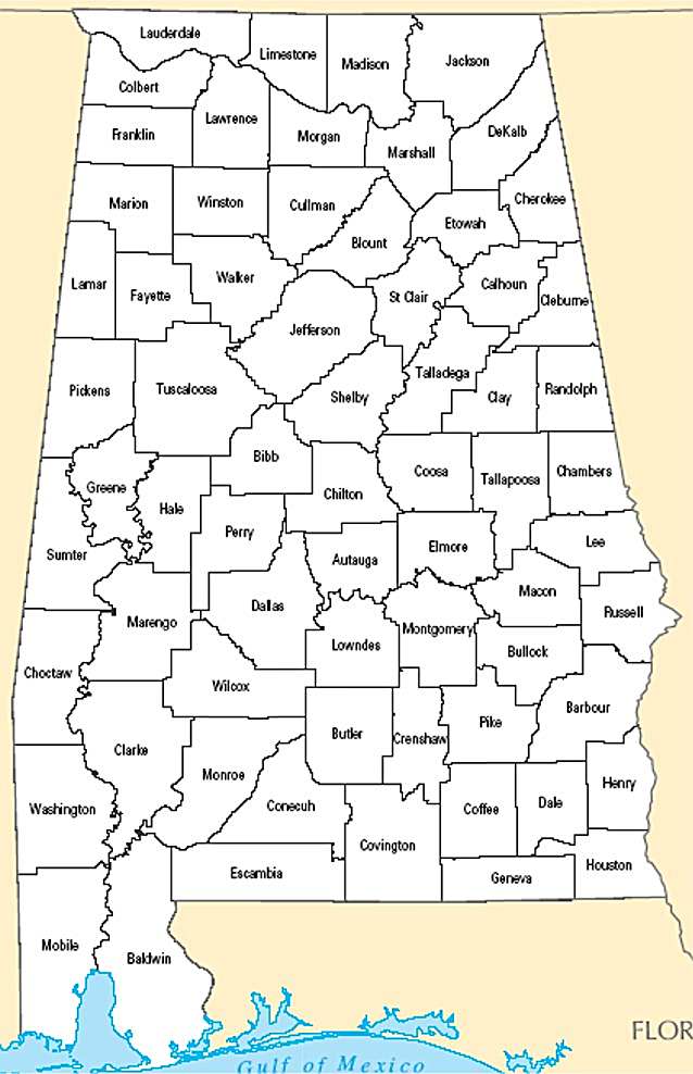
from the National Atlas of the United States
United States Department of the Interior
Alabama State Map
Map search is available for a limited number of queries per session to manage costs. Be specific — search precisely for best results.
| State | Alabama |
| Capital | Montgomery |
| Country | United States of America |
| Counties | 67 |
| Latitude | 32.806671 |
| Longitude | -86.79113 |
| Cities & Towns | 508 |
| State Map | Alabama Maps |
About Alabama
Alabama stretches from the craggy, sandstone foothills of the Appalachian chain in the north down to the salt-heavy air of the Gulf of Mexico. This landscape is defined by the Tennessee River, which carves a broad, fertile trench across the top of the state, before giving way to the central plains where red-clay back roads cut through longleaf pine forests and stands of bottomland hardwood. As the terrain slopes toward the coast, the geology shifts into sandy, porous earth and brackish marshes where the tides exert a constant, invisible pull. In the late afternoon, the light here has a heavy, amber quality that seems to catch in the humidity, turning the vast canopy of the woods into a deep, layered gray-green that feels ancient and waiting.
Alabama bears the indelible marks of its original inhabitants, including the Muscogee and Choctaw, whose presence preceded the arrival of French, Spanish, and British settlers. The subsequent centuries were defined by the forced expansion of plantation agriculture and the brutal institution of chattel slavery, which shaped the state’s political and social foundations in ways that still resonate in the present. This history is anchored by the weight of civil-rights memory, where long-fought struggles for justice fundamentally altered the national conscience. These formative episodes are not merely past events but are present in the way the land holds its silence, as if the soil itself remembers the gravity of the movements that surged across its bridges and courthouse squares.
Industry and agriculture remain the primary engines of the state, shifting from the historical dominance of king cotton to a complex modern economy of automotive assembly, aerospace engineering, and steel production. The black-belt soil, once the center of intense agrarian output, continues to support varied cultivation, while the northern territories lean into high-tech manufacturing and research. Farmers still tend to peach orchards and pecan groves, working the land with an inherited, quiet intensity that respects the cycles of the seasons. There is a distinct, heavy heat to the labor here, a sense that the work is performed in conversation with the climate, whether one is navigating the assembly line of a modern factory or checking the irrigation in a field of soybeans.
Alabama sustains a cultural landscape that moves at a deliberate, measured pace, often centered on the fiercely communal devotion to collegiate sports and the quiet, steady persistence of its literary tradition. Music—ranging from the soulful, blues-inflected rhythms of the river delta to the gospel harmonies heard in small, white-steeped churches—provides a soundtrack to daily life that is both mournful and celebratory. Food is treated as a language of hospitality, where the preparation of a meal is a primary way of mapping social connections and navigating the complexities of the day. In the evenings, when the cicadas begin their rhythmic pulse, the air thins just enough to allow the sounds of a neighborhood to drift across a porch, suggesting a state that is more comfortable with its own contradictions than it is with the frantic expectations of the outside world.
Alabama Cities and Towns by County
Baldwin County
Blount County
Calhoun County
Chambers County
Cullman County
Dale County
DeKalb County
Elmore County
Etowah County
Jackson County
Jefferson County
Madison County
Mobile County
Shelby County
Talladega County
Tallapoosa County
Washington County
Alabama County Maps & Location Information
This page provides an interactive Google map of Alabama (AL) with Street View, satellite and terrain views, alongside links to detailed street maps for all 508 cities and towns across the state organised by county. Alabama has 67 counties, with the state capital at Montgomery.
Every locality page includes an embedded street and satellite map alongside live weather where available — combining National Weather Service forecasts with Open-Meteo graphical data including hourly observations and 7-day outlooks. Local and world news feeds, Wikipedia summaries and editorially written descriptions are included where available.
Location data is sourced from the USGS GNIS database and the SimpleMaps US Cities dataset, verified by coordinates rather than name matching alone.
