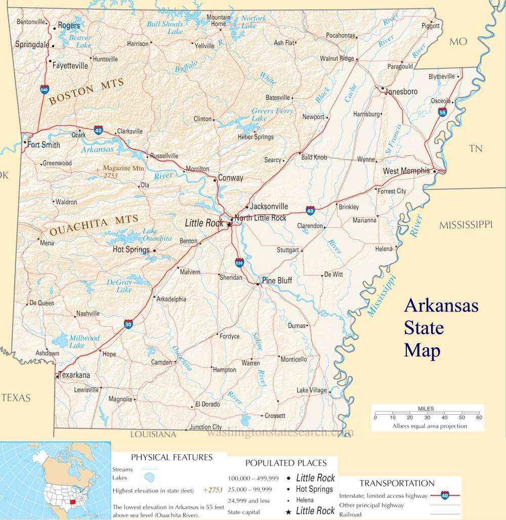
A large detailed map of Arkansas State
This is a large, detailed map of Arkansas. There are links to many Arkansas localities below.
View our Arkansas State county map
from the National Atlas of the United States
United States Department of the Interior
Arkansas State Map
Explore Arkansas with an interactive map featuring Street View, satellite and terrain views. Live weather, local news and location details for Arkansas — plus links to detailed street maps for 567 cities and towns across the state.
Map search is available for a limited number of queries per session to manage costs. Be specific — search precisely for best results.
| State | Arkansas (AR) |
| Capital | Little Rock |
| Largest City | Little Rock |
| Country | United States |
| Latitude | 35.0568 |
| Longitude | -92.4141 |
| Population | 3,011,524 |
| Cities & Towns | 567 |
About Arkansas
Arkansas unfolds with a captivating duality, a land sculpted by water and elevation. To the east, the Mississippi River Delta offers vast, fertile plains, a testament to alluvial richness, while westward, the Ouachita and Ozark Mountains rise, their ancient peaks cloaked in dense forests. These highlands, punctuated by clear springs and hidden hollows, give way to rolling hills and fertile river valleys, where the soil holds the promise of bounty. Crystal clear rivers like the White and Buffalo carve through the terrain, offering both scenic beauty and vital lifelines for the ecosystem and its inhabitants. Throughout Arkansas, a tapestry of natural wonders unfolds, from the diamond-bearing soil of Crater of Diamonds State Park to the serene beauty of the Buffalo National River, inviting exploration and quiet contemplation.
The story of Arkansas is woven from threads of ancient peoples and determined settlers. For millennia, indigenous communities thrived across this generous landscape, adapting to its varied environments and drawing sustenance from its abundant resources. The arrival of Europeans marked a profound shift, bringing new cultures and ambitions that would forever alter the trajectory of the region. Through periods of growth, conflict, and transformation, Arkansas solidified its identity, eventually joining the Union and forging its path as a distinct American state. The echoes of these past eras are still palpable, a quiet hum beneath the surface of contemporary life in Arkansas.
Agriculture remains a cornerstone of the Arkansas economy, with fertile lands yielding abundant crops like rice, soybeans, and cotton, alongside a robust poultry industry. Beyond the fields, manufacturing plays a significant role, encompassing everything from aerospace components to food processing, showcasing a diverse industrial base. The state also benefits from its natural resources, with significant contributions from the energy sector. Major cities and regional centers serve as hubs for commerce and innovation, fostering a dynamic economic environment that continues to evolve. This blend of traditional strength and forward-looking enterprise defines the economic character of Arkansas.
The cultural heart of Arkansas beats with a distinctive rhythm, a blend of Southern hospitality and a deep appreciation for its natural heritage. While professional sports teams may not call Arkansas home, college athletics, particularly football and basketball, ignite passionate rivalries and community spirit across the state. Annual events, from agricultural fairs to music festivals, draw crowds and celebrate local traditions, while the state's cuisine, rich with Southern influences, offers comforting and flavorful experiences. The character of daily life in Arkansas is often marked by a sense of community, a connection to the land, and an appreciation for the simple pleasures that make this region unique.
Arkansas City and Town Maps
A
B
C
D
E
F
G
H
I
J
K
L
M
N
O
P
Q
R
S
T
V
W
Z
Arkansas Maps — Interactive Map, Street View, Weather & News
This page provides an interactive Google map of Arkansas (AR) with Street View, satellite and terrain views, alongside links to detailed street maps for 567 cities and towns across the state. The state capital is Little Rock and the largest city is Little Rock, with a state population of approximately 3,011,524.
Each city and town map page includes an embedded street and satellite map. Live weather where available combines National Weather Service forecasts with Open-Meteo graphical data including hourly and 7-day outlooks. Local and world news, Wikipedia location summaries, and precise GPS coordinates are included where available.
Location data is sourced from the USGS GNIS database and verified by coordinates, not name matching alone.