A large detailed map of Arkansas State Counties
Explore Arkansas with an interactive map featuring Street View, satellite and terrain views. Browse all 75 counties of Arkansas below, with links to every city and town map page. Live weather and local news are included on every location page.
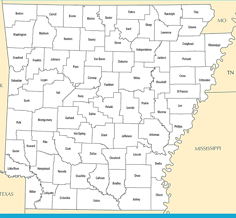
from the National Atlas of the United States
United States Department of the Interior
Arkansas State Map
Map search is available for a limited number of queries per session to manage costs. Be specific — search precisely for best results.
| State | Arkansas |
| Capital | Little Rock |
| Country | United States of America |
| Counties | 75 |
| Latitude | 34.969704 |
| Longitude | -92.373123 |
| Cities & Towns | 567 |
| State Map | Arkansas Maps |
About Arkansas
Arkansas occupies a rugged transition between the high, fractured plateaus of the interior highlands and the alluvial plains that track the slow, heavy movement of the Mississippi River. To the northwest, the land rises into ancient, timbered ridges where the air holds a persistent, cool clarity and the creek beds are paved with chert and limestone. Moving eastward, the topography flattens into an expansive, black-soiled basin, a landscape defined by the deliberate, serpentine paths of bayous and the wide, sun-drenched horizons of the Delta. In the heat of mid-July, the light here thickens, turning a deep, syrupy gold that makes the distant tree lines appear to float above the shimmering asphalt of the rural roads. This contrast between the vertical, shadow-filled hollows and the horizontal, open expanse of the lowlands gives Arkansas a physical duality that dictates the flow of water and the settlement of its people.
Indigenous nations, including the Osage, Caddo, and Quapaw, shaped the early landscape through trade, seasonal migration, and a profound understanding of the river systems long before European expeditions arrived to claim the territory for distant empires. Following the Louisiana Purchase, the territory drew a steady influx of settlers who moved into the river valleys, clearing the dense stands of hardwood to establish homesteads that eventually formed the basis for statehood in the mid-nineteenth century. The state’s formative years were marked by the difficult, often violent transition from a frontier society to a structured political entity, a process etched into the social landscape by the lingering scars of regional conflict. Through every era, the Arkansas soil has remained a witness to these shifts, holding the memory of those who worked the land and the quiet, persistent resilience of communities that grew in the wake of displacement and reconstruction.
Agriculture has always been the primary pulse of the state, with the fertile Delta fields yielding vast harvests of rice, soybeans, and cotton, while the upland regions have historically relied upon timber, poultry production, and small-scale livestock operations. This economic base has evolved from simple subsistence farming into a sophisticated network of global distribution, yet the physical labor of the harvest remains a grounding force for many who live here. The scent of drying straw and damp earth often hangs heavy in the autumn air, a reminder of the cyclical nature of a life tied to the seasonal demands of the field. Beyond the plow, the state has diversified into aerospace, retail logistics, and manufacturing, grounding its modern identity in an infrastructure that connects its rural outputs to international markets while maintaining a firm grip on the traditions of its agrarian heritage.
Cultural life in Arkansas is defined by a distinct, unhurried vernacular and a communal focus that centers on the shared rituals of collegiate sports, faith, and the table. The cadence of local speech is slow and melodic, a soft drawl that seems to match the pace of the rivers moving through the woods. On crisp Saturday afternoons, the attention of the entire state converges on the performance of its athletic teams, a tradition that serves as a primary social anchor for both the urban centers and the isolated rural outposts. Food here is a matter of geography, ranging from the spicy, slow-cooked barbecue of the lowlands to the hearty, game-rich fare of the highlands, all served with a hospitality that assumes the visitor is a guest for the duration of their stay. In the quiet hours of dusk, when the cicadas begin their rhythmic drone and the blue shadows stretch across the fields, one can feel the unique gravity of Arkansas, a place that values the specific weight of a person’s word and the enduring comfort of a familiar, quiet horizon.
Arkansas Cities and Towns by County
Ashley County
Baxter County
Benton County
Boone County
Crittenden County
Independence County
Jackson County
Logan County
Pulaski County
Sebastian County
Union County
Washington County
Arkansas County Maps & Location Information
This page provides an interactive Google map of Arkansas (AR) with Street View, satellite and terrain views, alongside links to detailed street maps for all 567 cities and towns across the state organised by county. Arkansas has 75 counties, with the state capital at Little Rock.
Every locality page includes an embedded street and satellite map alongside live weather where available — combining National Weather Service forecasts with Open-Meteo graphical data including hourly observations and 7-day outlooks. Local and world news feeds, Wikipedia summaries and editorially written descriptions are included where available.
Location data is sourced from the USGS GNIS database and the SimpleMaps US Cities dataset, verified by coordinates rather than name matching alone.
