A large detailed map of Delaware State
This is a large, detailed map of Delaware. There are links to many Delaware localities below. Our website format reduces the display size for uniformity. Here is a link to the full-size image that is more easily readable.
View our Delaware State county map
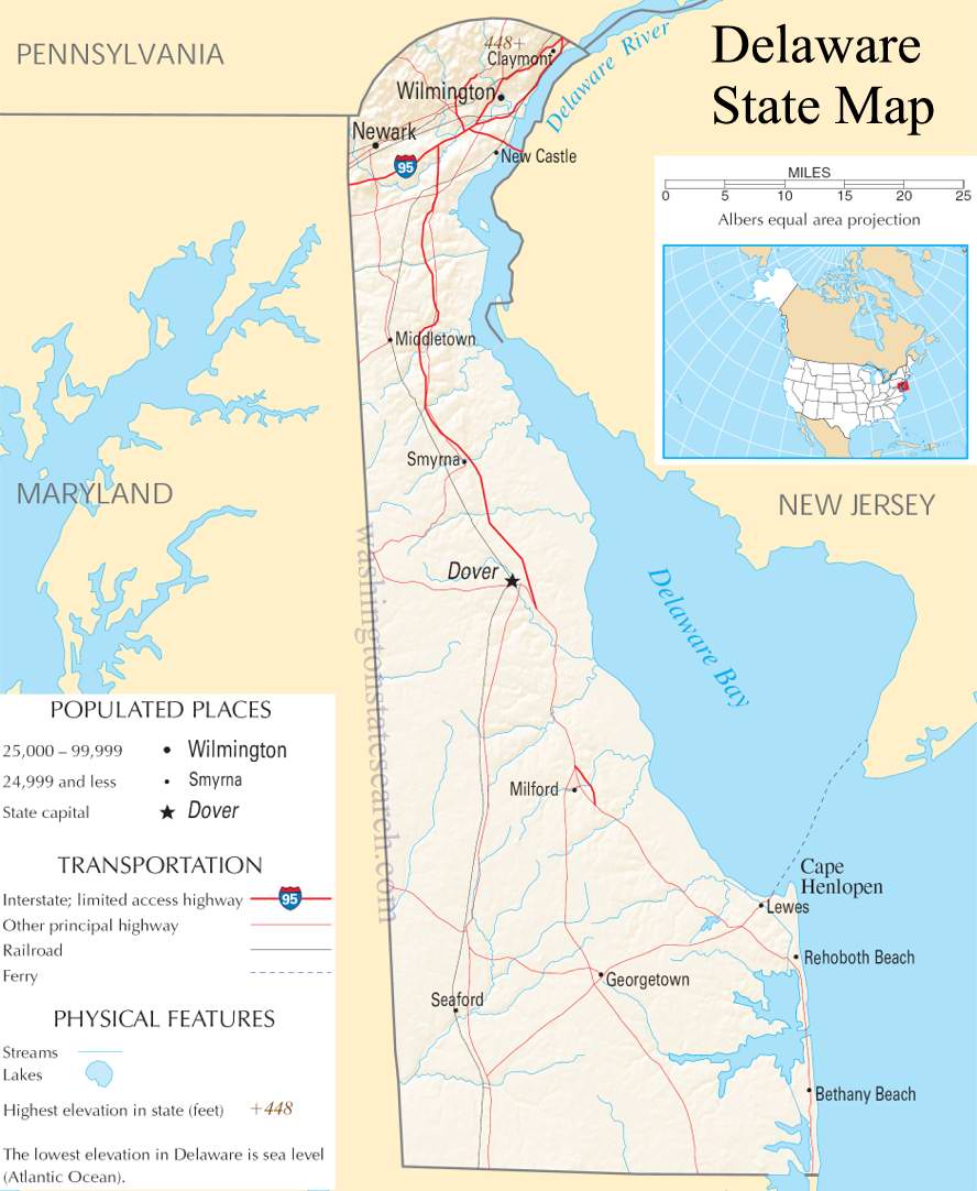
from the National Atlas of the United States
United States Department of the Interior
Delaware State Map
Explore Delaware with an interactive map featuring Street View, satellite and terrain views. Live weather, local news and location details for Delaware — plus links to detailed street maps for 74 cities and towns across the state.
Map search is available for a limited number of queries per session to manage costs. Be specific — search precisely for best results.
| State | Delaware (DE) |
| Capital | Dover |
| Largest City | Wilmington |
| Country | United States |
| Latitude | 39.318523 |
| Longitude | -75.507141 |
| Population | 989,948 |
| Cities & Towns | 74 |
Delaware occupies a narrow, low-slung corridor between the Delaware River and the Atlantic, a landscape defined by the relentless work of water. To the north, the land rises into the gentle, crystalline rock of the Piedmont, where clear streams cut through deep woods, while the southern expanse stretches into flat, sandy plains and vast tidal marshes that breathe with the tides of the bay. The air here holds a particular, heavy sweetness near the coast, where the salt spray meets the dark, rich earth of the interior. It is a place of subtle gradients, where the horizon feels impossibly wide and the light at dusk turns the marsh grasses into a shimmering, bruised gold that seems to hold the day long after the sun has slipped away.
Delaware emerged from a complicated collision of ambitions, beginning with the Indigenous nations who navigated its waterways and moving through the overlapping claims of Dutch, Swedish, and English settlers. These early arrivals built small forts and sturdy stone houses, establishing a presence that eventually anchored the state’s role as the first to ratify the Constitution. The formative years were marked by a quiet tenacity, as communities learned to survive in a borderland that served as a buffer between larger colonial powers. This history remains visible in the architecture of older neighborhoods, where the brickwork and heavy timber frames suggest a people who valued permanence and were willing to build their lives in the shadow of shifting political tides.
Industry and agriculture have long dictated the rhythm of life in Delaware, creating a distinct economic identity that balances the corporate with the pastoral. In the northern reaches, the legacy of chemical manufacturing and massive industrial estates shaped the landscape and the livelihood of generations, while the southern counties remain dominated by the quiet, methodical labor of broiler-chicken farms. The fields are vast and utilitarian, often humming with the sound of machinery, yet there is a profound dignity in the way the land is worked. This dual existence—of boardroom corridors and poultry houses—has produced a pragmatic, industrious populace that views the land not as a scenic backdrop but as a source of sustenance and stability.
Delaware maintains a character that is defined by its unassuming pace and a deep-seated preference for the local. Life unfolds in the quiet bustle of community gatherings, high school sporting events held under the hum of stadium lights, and the seasonal migration toward the Atlantic beach towns when the humidity rises. The food reflects the geography, leaning heavily on the catch of the bay and the bounty of the surrounding farms, served with a simplicity that mirrors the state’s modest posture. There is a perceptible stillness in the morning air before the traffic begins, a moment when the state feels entirely composed of its own quiet, steady heartbeat, indifferent to the noise of the neighboring metropolises and content in its own singular, unremarkable grace.
Delaware City and Town Maps
A
B
D
F
G
H
K
N
O
S
Delaware Maps — Interactive Map, Street View, Weather & News
This page provides an interactive Google map of Delaware (DE) with Street View, satellite and terrain views, alongside links to detailed street maps for 74 cities and towns across the state. The state capital is Dover and the largest city is Wilmington, with a state population of approximately 989,948.
Each city and town map page includes an embedded street and satellite map. Live weather where available combines National Weather Service forecasts with Open-Meteo graphical data including hourly and 7-day outlooks. Local and world news, Wikipedia location summaries, and precise GPS coordinates are included where available.
Location data is sourced from the USGS GNIS database and verified by coordinates, not name matching alone.
