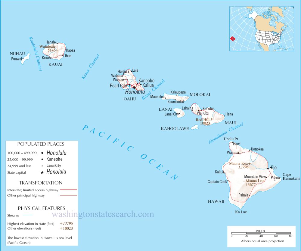
A large detailed map of Hawaii State
This is a large, detailed map of Hawaii. There are links to many Hawaii localities below.
View our Hawaii State county map
from the National Atlas of the United States
United States Department of the Interior
Hawaii State Map
Explore Hawaii with an interactive map featuring Street View, satellite and terrain views. Live weather, local news and location details for Hawaii — plus links to detailed street maps for 154 cities and towns across the state.
Map search is available for a limited number of queries per session to manage costs. Be specific — search precisely for best results.
| State | Hawaii (HI) |
| Capital | Honolulu |
| Largest City | Honolulu |
| Country | United States |
| Latitude | 20.8036 |
| Longitude | -157.0461 |
| Population | 1,455,271 |
| Cities & Towns | 154 |
About Hawaii
Hawaii's landscape is a breathtaking tapestry woven from volcanic fire and the ceaseless caress of the Pacific. Towering volcanic peaks, some still active, dominate the interior, their slopes giving way to verdant rainforests that cascade down to the sea. Along its extensive coastlines, dramatic cliffs plunge into turquoise waters, interspersed with golden, black, and even green sand beaches, each a testament to the islands' fiery origins. Diverse climate zones flourish, from the steamy tropical lowlands to the cool, windswept alpine regions atop the highest mountains, creating a rich mosaic of natural habitats. Majestic national parks and countless state parks protect these wonders, preserving the raw beauty of Hawaii for all to behold.
The history of Hawaii is a rich narrative of resilience and adaptation, beginning with its original Polynesian navigators who found these remote islands. For centuries, these voyagers developed a unique culture, deeply connected to the land and sea, before European contact brought profound changes. Following a period of annexation, Hawaii eventually became the fiftieth United States, a momentous occasion that reshaped its destiny. Over decades, the islands have evolved into a vibrant, multicultural society, a harmonious blend of ancient traditions and modern influences that define contemporary Hawaii.
The economy of Hawaii is as varied as its terrain, with tourism serving as its most prominent industry, drawing visitors to its unparalleled beauty and warm hospitality. Agriculture also plays a significant role, with pineapple and sugarcane plantations once dominating, now yielding to macadamia nuts, coffee, and tropical fruits. Manufacturing, though smaller in scale, contributes to the state's economic output, alongside a growing technology sector and a robust service industry. Major cities and regional centers across the islands serve as hubs for commerce and daily life, bustling with activity against a backdrop of natural splendor in Hawaii.
The cultural identity of Hawaii is a vibrant celebration of its diverse heritage, marked by the spirit of aloha that permeates daily life. While professional sporting teams are not based in Hawaii, college athletics, particularly football and basketball, generate immense local passion and pride. The islands host numerous annual events, from traditional luaus and hula festivals to world-renowned surf competitions, showcasing the state's unique traditions. The cuisine is a delightful fusion of flavors, influenced by Asian, Polynesian, and American traditions, featuring fresh seafood and tropical produce. Cultural landmarks abound, from ancient heiau (temples) to historic plantations, each whispering stories of Hawaii's enduring spirit.
Hawaii City and Town Maps
E
H
K
L
M
O
P
U
W
Hawaii Maps — Interactive Map, Street View, Weather & News
This page provides an interactive Google map of Hawaii (HI) with Street View, satellite and terrain views, alongside links to detailed street maps for 154 cities and towns across the state. The state capital is Honolulu and the largest city is Honolulu, with a state population of approximately 1,455,271.
Each city and town map page includes an embedded street and satellite map. Live weather where available combines National Weather Service forecasts with Open-Meteo graphical data including hourly and 7-day outlooks. Local and world news, Wikipedia location summaries, and precise GPS coordinates are included where available.
Location data is sourced from the USGS GNIS database and verified by coordinates, not name matching alone.