A large detailed map of Kansas State Counties
Explore Kansas with an interactive map featuring Street View, satellite and terrain views. Browse all 105 counties of Kansas below, with links to every city and town map page. Live weather and local news are included on every location page.
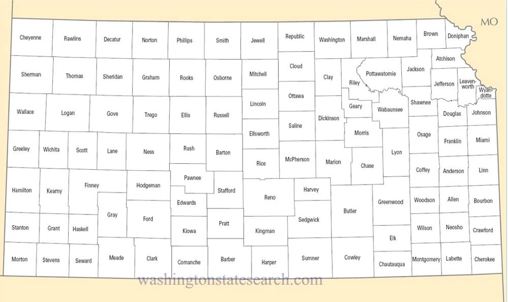
from the National Atlas of the United States
United States Department of the Interior
Kansas State Map
Map search is available for a limited number of queries per session to manage costs. Be specific — search precisely for best results.
| State | Kansas |
| Capital | Topeka |
| Country | United States of America |
| Counties | 105 |
| Latitude | 38.5266 |
| Longitude | -96.726486 |
| Cities & Towns | 736 |
| State Map | Kansas Maps |
About Kansas
Kansas rises from the continental center as a vast, tilted plane, where the elevation climbs imperceptibly from the eastern river valleys toward the high, arid western reaches. The physical land is defined by the relentless reach of the sky, which often dominates the horizon with a heavy, bruised light before a storm. To the east, the Flint Hills break the monotony of the flatlands with jagged ridges of limestone and the deep, swaying vitality of native tallgrass, while elsewhere, the terrain is shaped by the slow, persistent carving of the Arkansas and Republican rivers. Cottonwood trees cluster in the low, sheltered dampness of creek beds, their pale leaves rattling in the constant breeze that seems to have been blowing since the dawn of the plains. This is a geography of exposure, where the earth is stripped of pretense and the weather acts as the primary architect of the day.
Indigenous nations, including the Kanza, Osage, and Pawnee, traversed these prairies long before the arrival of European explorers who sought, and failed to find, their imagined golden cities. The territory emerged as a volatile theater for the nation’s deepest moral fractures, becoming a crucible of conflict over the expansion of slavery that served as a grim prelude to the Civil War. By the time Kansas entered the Union, it had already been baptized in the fire of ideological struggle. Settlers who followed were often confronted by the harsh reality of a landscape that demanded extreme resilience, particularly during the years when the soil turned to dust and the winds scoured the earth bare. This history remains a quiet presence in the architecture of the state, where the solid, blocky limestone courthouses in every seat of government feel like anchors dropped into a shifting sea of grass.
Agriculture remains the primary pulse of the state, though the nature of that work has evolved from the early, back-breaking homesteading to a sophisticated, mechanized enterprise. The vast, amber wheat horizons are the state’s most recognizable signature, yet the economy now balances this traditional reliance on the soil with a robust presence in aviation manufacturing and aerospace engineering. Workers in the industrial centers contribute to a global supply chain, building wings and fuselages with the same pragmatic precision that a farmer applies to a harvest. There is a distinct, rhythmic cycle to the year here, dictated by the planting and the reaping, which anchors the population to the land even as they look toward technological horizons. The state has long understood that survival depends on the ability to turn a challenging climate into a predictable yield, a task that requires a stubborn, quiet ingenuity.
Cultural life in Kansas is characterized by an understated intensity, manifested in the fervor of collegiate sports that can turn an entire town into a singular, vocal collective on a Saturday afternoon. The social fabric is held together by traditions that prioritize community gatherings and a shared, grounded perspective on the world. Literature and music here often reflect the solitude of the plains, capturing the specific, haunting resonance of a wind-swept porch or the lonely whistle of a freight train cutting through the dark. Foodways are unpretentious and hearty, drawing from a blend of immigrant influences that have left their mark on the local palate. Life moves with a deliberate pace, governed by the realization that in a land so wide and open, one’s reputation and actions are visible from a great distance, fostering a culture that values reliability and a steady, unspoken sense of neighborly duty.
Kansas Cities and Towns by County
Barton County
Brown County
Cowley County
Jefferson County
Johnson County
Marshall County
Montgomery County
Osage County
Phillips County
Pottawatomie County
Reno County
Saline County
Sedgwick County
Sumner County
Washington County
Kansas County Maps & Location Information
This page provides an interactive Google map of Kansas (KS) with Street View, satellite and terrain views, alongside links to detailed street maps for all 736 cities and towns across the state organised by county. Kansas has 105 counties, with the state capital at Topeka.
Every locality page includes an embedded street and satellite map alongside live weather where available — combining National Weather Service forecasts with Open-Meteo graphical data including hourly observations and 7-day outlooks. Local and world news feeds, Wikipedia summaries and editorially written descriptions are included where available.
Location data is sourced from the USGS GNIS database and the SimpleMaps US Cities dataset, verified by coordinates rather than name matching alone.
