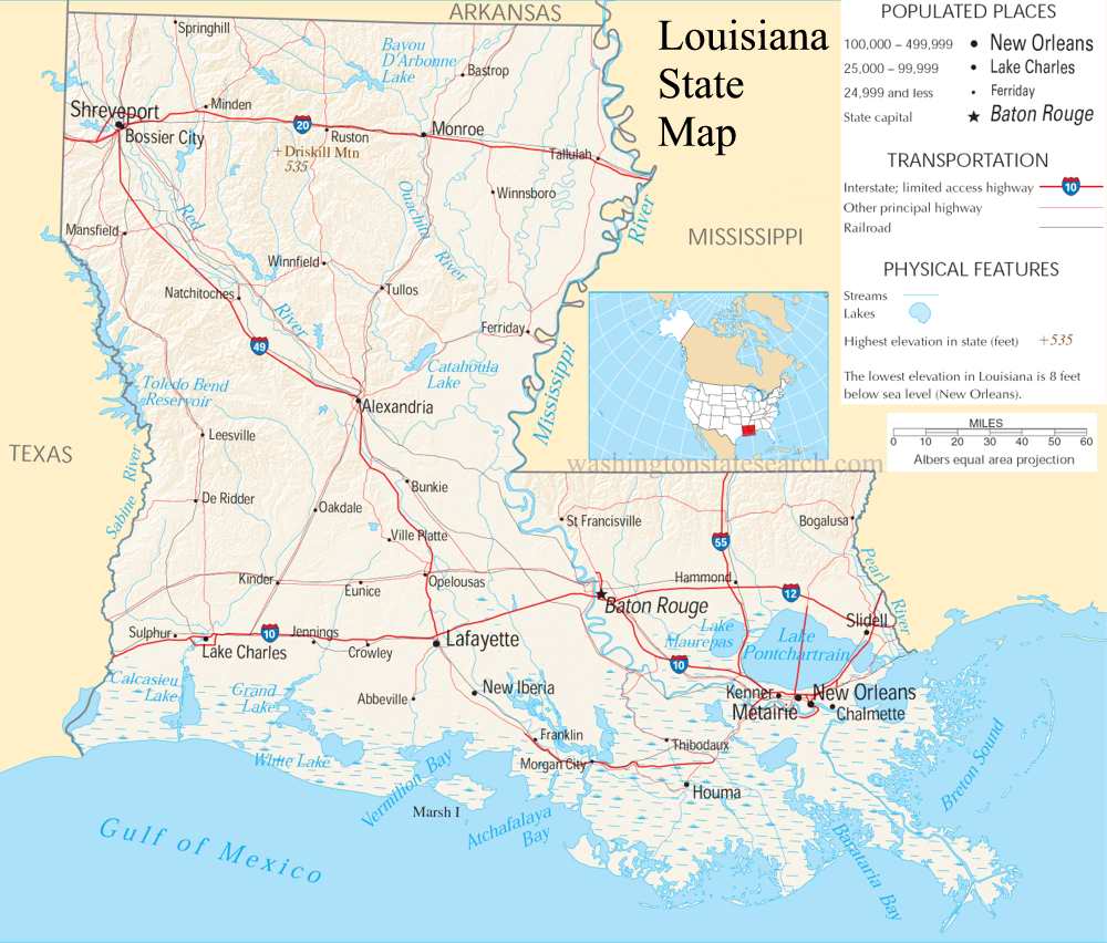
A large detailed map of Louisiana State
This is a large, detailed map of Louisiana. There are links to many Louisiana localities below.
View our Louisiana State county map
from the National Atlas of the United States
United States Department of the Interior
Louisiana State Map
Explore Louisiana with an interactive map featuring Street View, satellite and terrain views. Live weather, local news and location details for Louisiana — plus links to detailed street maps for 449 cities and towns across the state.
Map search is available for a limited number of queries per session to manage costs. Be specific — search precisely for best results.
| State | Louisiana (LA) |
| Capital | Baton Rouge |
| Largest City | New Orleans |
| Country | United States |
| Latitude | 30.9586 |
| Longitude | -91.831 |
| Population | 4,657,757 |
| Cities & Towns | 449 |
About Louisiana
Louisiana's heartland unfolds as a tapestry of alluvial plains, where ancient rivers have sculpted a landscape of gentle contours and fertile soil. Vast stretches of wetlands, bayous, and marshes define its southern reaches, creating a unique aquatic environment that teems with life and influences the very rhythm of existence here. Inland, the terrain transitions to rolling hills and pine forests, offering a striking contrast to the coastal marshlands. The mighty Mississippi River, a lifeblood of the continent, meanders through Louisiana, shaping its geography and dictating its settlement patterns for centuries. This humid, subtropical climate bathes the land in a warm, often verdant glow, fostering lush vegetation and a distinct, watery beauty across Louisiana.
The story of Louisiana is one of enduring cultures and layered histories, deeply rooted in the land. Indigenous peoples have called this region home for millennia, their ancient connections to the bayous and forests shaping the earliest human presence. European powers, notably France and Spain, later left indelible marks, introducing new languages, traditions, and architectural styles that still resonate today. Through periods of territorial change and eventual statehood, Louisiana has woven together a rich cultural heritage, a vibrant mosaic of influences that define its unique character. This complex past has forged a resilient and distinctive identity for Louisiana, one that embraces its diverse origins.
The economy of Louisiana thrives on a foundation of abundant natural resources and strategic waterways. Agriculture, particularly sugarcane and rice cultivation, remains a significant sector, drawing sustenance from the rich alluvial soils. However, the state is perhaps most widely recognized for its powerful energy industry, encompassing oil and natural gas extraction and refining, which fuel a substantial portion of the nation's needs. Beyond these cornerstones, manufacturing, including shipbuilding and chemical production, adds further depth to Louisiana's industrial output. Major cities like New Orleans and Baton Rouge serve as vital economic and cultural hubs, anchoring a diverse range of industries and employment opportunities across Louisiana.
Louisiana's cultural identity is as potent and flavorful as its renowned cuisine, a captivating blend of French, Spanish, African, and Caribbean influences. The spirit of this state is often expressed through vibrant music, from the soulful strains of jazz to the infectious rhythms of zydeco, filling neighborhoods and festivals with an undeniable energy. Major annual events, such as Mardi Gras, draw global attention, showcasing the state's penchant for celebration and community. Daily life in Louisiana moves at its own pace, characterized by a deep appreciation for family, tradition, and the simple pleasures of good food and good company. The passion for college sports, particularly football, runs deep, uniting communities in fervent support for their beloved teams throughout Louisiana.
Louisiana City and Town Maps
A
B
C
D
E
F
G
H
I
J
K
L
M
N
O
P
Q
R
S
T
V
W
Louisiana Maps — Interactive Map, Street View, Weather & News
This page provides an interactive Google map of Louisiana (LA) with Street View, satellite and terrain views, alongside links to detailed street maps for 449 cities and towns across the state. The state capital is Baton Rouge and the largest city is New Orleans, with a state population of approximately 4,657,757.
Each city and town map page includes an embedded street and satellite map. Live weather where available combines National Weather Service forecasts with Open-Meteo graphical data including hourly and 7-day outlooks. Local and world news, Wikipedia location summaries, and precise GPS coordinates are included where available.
Location data is sourced from the USGS GNIS database and verified by coordinates, not name matching alone.