A large detailed map of Louisiana State Counties
Explore Louisiana with an interactive map featuring Street View, satellite and terrain views. Browse all 64 counties of Louisiana below, with links to every city and town map page. Live weather and local news are included on every location page.
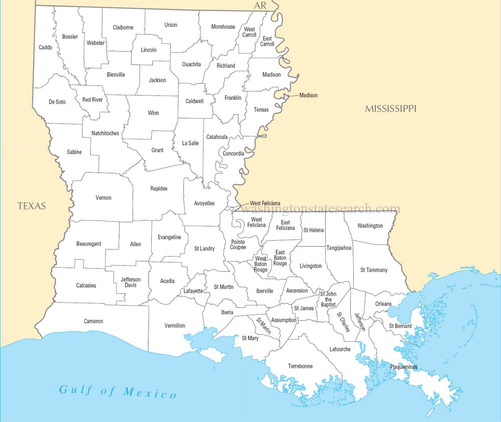
from the National Atlas of the United States
United States Department of the Interior
Louisiana State Map
Map search is available for a limited number of queries per session to manage costs. Be specific — search precisely for best results.
| State | Louisiana |
| Capital | Baton Rouge |
| Country | United States of America |
| Counties | 64 |
| Latitude | 31.16996 |
| Longitude | -91.867805 |
| Cities & Towns | 449 |
| State Map | Louisiana Maps |
About Louisiana
Louisiana stretches across a low, damp expanse where the land seems less a solid foundation and more a porous negotiation between silt and tide. The Mississippi River carves a deep, serpentine artery through the center, depositing the rich, dark sediment that defines the fertility of the deltaic plain. To the west, the coastal prairies give way to a labyrinth of bayous, where cypress knees emerge from still, tea-colored water like the fingers of a submerged forest. At dusk, the light loses its sharpness, bruising into shades of violet and bruised gold that press against the humid air, cooling the swamp until the evening chorus of frogs begins its steady, rhythmic pulse. This is a geography of constant movement, where the coastline is perpetually reshaped by the currents and the slow, inexorable pull of the Gulf of Mexico.
Indigenous nations cultivated these riverbanks for millennia before the arrival of European powers, establishing complex networks of trade and society long before the shifting allegiances of empires turned the territory into a chessboard. French, Spanish, and later American interests collided here, leaving behind a legacy of civil law and shifting borders that shaped the state’s distinct political anatomy. When Louisiana entered the Union, it brought with it a social architecture defined by the persistence of its early inhabitants and the arrival of those forced into labor, creating a society that never fully homogenized. The weight of this past lingers in the architecture of the older parishes, where the brick walls seem to hold the heat of centuries, and the quiet dignity of the landscape bears witness to the endurance of those who carved their lives out of the swampy wilderness.
Agriculture and industry here operate under the heavy influence of the water, which dictates the rhythm of production as much as any market demand. Fields of sugarcane extend toward the horizon in emerald rows, while the flooded plains provide the necessary environment for rice cultivation, a practice that has anchored the rural economy for generations. Beyond the fields, the state remains a vital corridor for global commerce, with massive tankers navigating the deep-water channels that serve as the throat of the nation’s interior trade. Industrial plants, their metallic silhouettes often looming against a heavy, gray sky, stand in contrast to the quiet, mud-slicked banks where small-scale fishing and trapping still persist. It is a place where the extraction of mineral wealth exists in uneasy proximity to the fragile, marshy ecosystems that define the state’s physical identity.
Cultural life in Louisiana thrives in the spaces between the formal and the vernacular, expressed through a devotion to music that ranges from the improvisational complexity of jazz to the percussive, driving energy of zydeco. Food serves as a primary language, with recipes passed down with the precision of a ritual, relying on the local abundance of seafood and the specific heat of peppers grown in the damp soil. The pace of daily life is dictated by the climate, which demands a certain patience; when the air turns heavy and motionless, the world seems to slow, allowing for a contemplative pause that finds its way into the local cadence of speech. Whether at a collegiate stadium filled with the roar of a Saturday crowd or in a quiet neighborhood where the scent of woodsmoke hangs in the humid air, the people maintain a fierce attachment to their traditions, finding beauty in the persistence of their own unique, unhurried ways.
Louisiana Cities and Towns by County
Avoyelles County
Caddo County
De Soto County
East Baton Rouge County
Jefferson County
Lafourche County
Livingston County
Natchitoches County
Ouachita County
Plaquemines County
St. James County
St. Landry County
St. Mary County
St. Tammany County
Tangipahoa County
Vernon County
Louisiana County Maps & Location Information
This page provides an interactive Google map of Louisiana (LA) with Street View, satellite and terrain views, alongside links to detailed street maps for all 449 cities and towns across the state organised by county. Louisiana has 64 counties, with the state capital at Baton Rouge.
Every locality page includes an embedded street and satellite map alongside live weather where available — combining National Weather Service forecasts with Open-Meteo graphical data including hourly observations and 7-day outlooks. Local and world news feeds, Wikipedia summaries and editorially written descriptions are included where available.
Location data is sourced from the USGS GNIS database and the SimpleMaps US Cities dataset, verified by coordinates rather than name matching alone.
