A large detailed map of Maryland State Counties
Explore Maryland with an interactive map featuring Street View, satellite and terrain views. Browse all 24 counties of Maryland below, with links to every city and town map page. Live weather and local news are included on every location page.
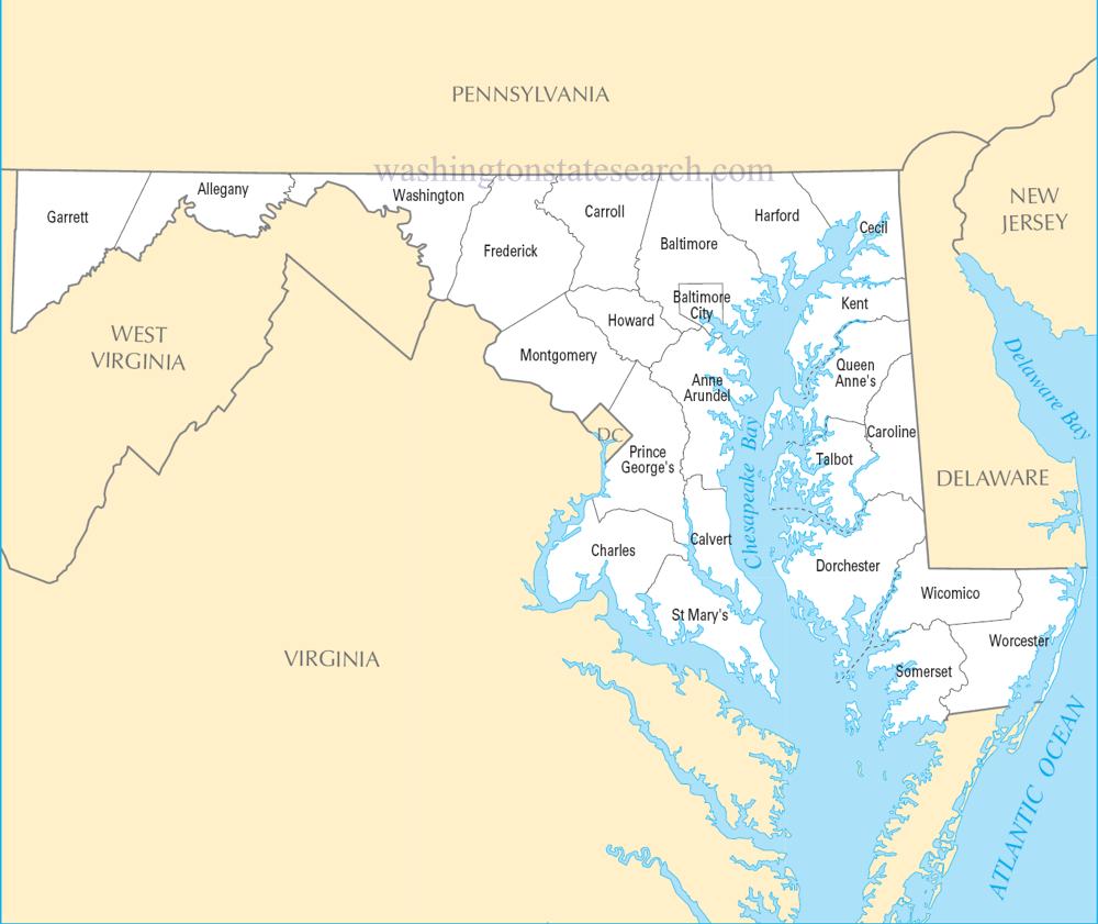
from the National Atlas of the United States
United States Department of the Interior
Maryland State Map
Map search is available for a limited number of queries per session to manage costs. Be specific — search precisely for best results.
| State | Maryland |
| Capital | Annapolis |
| Country | United States of America |
| Counties | 24 |
| Latitude | 39.063946 |
| Longitude | -76.802101 |
| Cities & Towns | 640 |
| State Map | Maryland Maps |
About Maryland
Maryland stretches from the low, salt-stung marshes of the Atlantic coast to the jagged, blue-shadowed ridges of the Appalachian spine, encompassing a landscape defined by the relentless intrusion of the Chesapeake. The state acts as a vast, watery intersection where the tides push deep into the interior, turning the land into a fractured jigsaw of peninsulas and winding creeks. To the east, the ground is flat and porous, a place where the horizon often dissolves into the gray shimmer of the bay, while the western reaches rise into a heavy, forested terrain of limestone and shale. In the late afternoon, the light here takes on a peculiar, liquid quality, reflecting off the brackish estuaries until the sky and the water seem to trade places in the cooling air.
Indigenous nations, including the Nanticoke and the Piscataway, moved through these river valleys for millennia before the arrival of European ships, which charted the intricate inlets and established a foothold that would eventually anchor the state in the colonial Atlantic world. The early years of Maryland were defined by the struggle to reconcile proprietary grants with the realities of a frontier, leading to a complex social order built upon tobacco cultivation and the forced labor of enslaved people. This history remains visible in the architecture of older river ports, where the brick structures still hold the damp chill of the harbor. The state’s trajectory shifted as it became a cockpit of maritime commerce and revolutionary fervor, eventually solidifying its identity as a border territory that would be pulled in opposing directions during the conflicts of the nineteenth century.
Agriculture and industry have long vied for dominance in the local consciousness, moving from the labor-intensive fields of the colonial era to the modern complexities of biotechnology and naval logistics. The bay continues to dictate the rhythm of life for those who harvest the blue crab and the oyster, maintaining a link to a traditional economy that persists despite the encroachment of sprawling suburban development. Away from the water, the state has diversified into high-tech research and federal administration, creating a friction between the old guard of the rural interior and the fast-paced corridors of the capital region. This duality forces a constant negotiation of space, where the smell of diesel and damp soil often lingers in the same morning breeze, grounding the economy in both the tangible yield of the earth and the invisible output of the laboratory.
Cultural life in Maryland possesses a distinct, somewhat insular pride, shaped by a dialect that catches in the back of the throat and a culinary devotion to the seasoned, steamed crustacean. The social landscape is marked by a deep allegiance to collegiate sports and a lingering attachment to urban neighborhoods where the white-painted stoops provide a stage for the daily observations of the residents. Music, ranging from the percussive, syncopated beats of local brass bands to the quiet folk traditions of the mountain hollows, mirrors the state’s internal divisions. Whether gathered at a crowded crab shack on a humid July evening or walking through the quiet, frost-covered streets of a western ridge town, there is a sense of deliberate pace, a stubborn refusal to be anything other than exactly what the geography and history have demanded.
Maryland Cities and Towns by County
Allegany County
Anne Arundel County
Baltimore County
Baltimore (city) County
Calvert County
Caroline County
Carroll County
Cecil County
Charles County
Dorchester County
Frederick County
Garrett County
Harford County
Howard County
Kent County
Montgomery County
Prince George's County
Queen Anne's County
Somerset County
St. Mary's County
Talbot County
Washington County
Wicomico County
Worcester County
Maryland County Maps & Location Information
This page provides an interactive Google map of Maryland (MD) with Street View, satellite and terrain views, alongside links to detailed street maps for all 640 cities and towns across the state organised by county. Maryland has 24 counties, with the state capital at Annapolis.
Every locality page includes an embedded street and satellite map alongside live weather where available — combining National Weather Service forecasts with Open-Meteo graphical data including hourly observations and 7-day outlooks. Local and world news feeds, Wikipedia summaries and editorially written descriptions are included where available.
Location data is sourced from the USGS GNIS database and the SimpleMaps US Cities dataset, verified by coordinates rather than name matching alone.
