A large detailed map of Michigan State
This is a large, detailed map of Michigan. There are links to many Michigan localities below. Our website format reduces the display size for uniformity. Here is a link to the full-size image that is more easily readable.
View our Michigan State county map
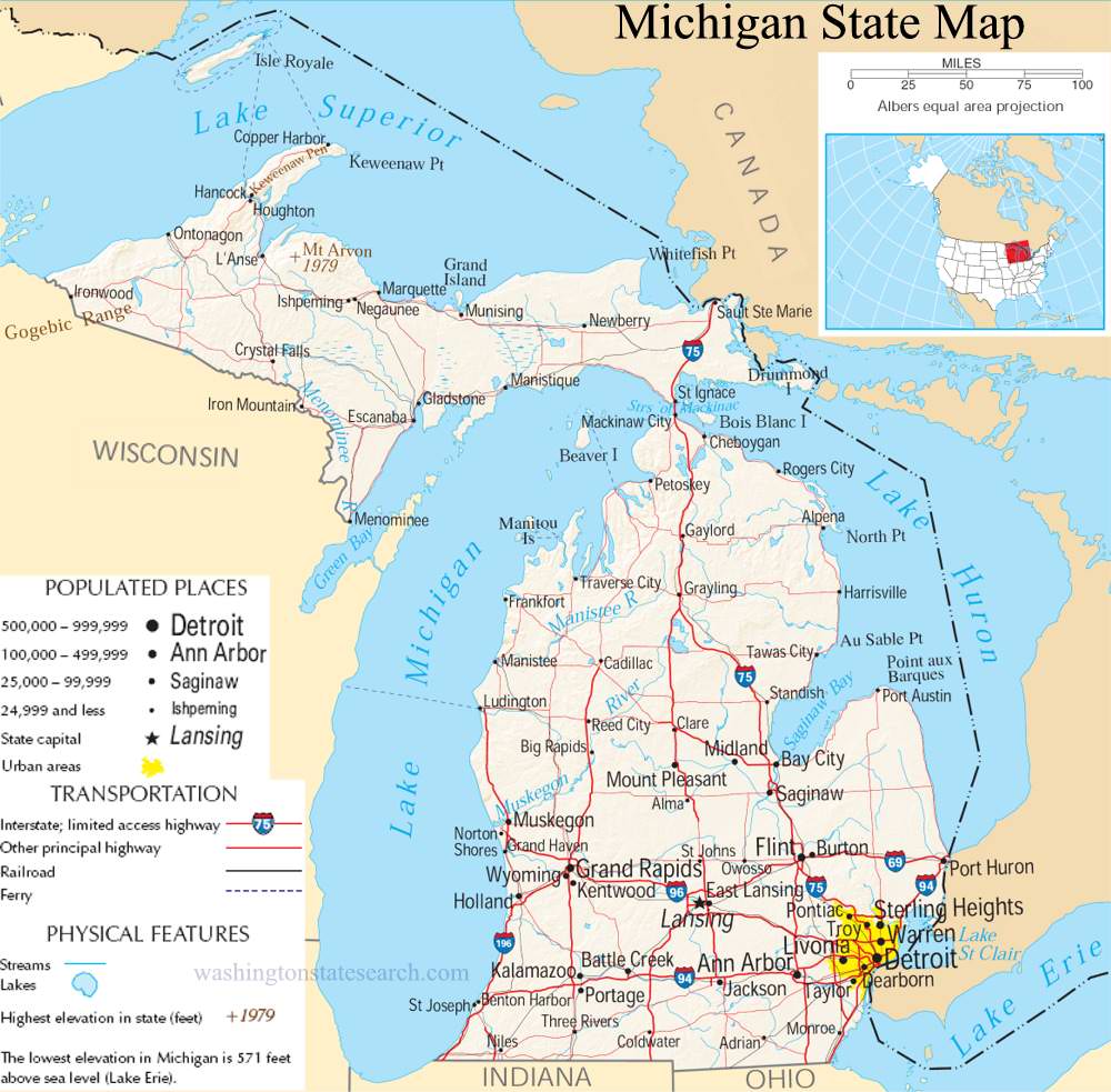
from the National Atlas of the United States
United States Department of the Interior
Michigan State Map
Explore Michigan with an interactive map featuring Street View, satellite and terrain views. Live weather, local news and location details for Michigan — plus links to detailed street maps for 1,051 cities and towns across the state.
Map search is available for a limited number of queries per session to manage costs. Be specific — search precisely for best results.
| State | Michigan (MI) |
| Capital | Lansing |
| Largest City | Detroit |
| Country | United States |
| Latitude | 43.326618 |
| Longitude | -84.536095 |
| Population | 10,077,331 |
| Cities & Towns | 1,051 |
Michigan asserts its presence through the sheer volume of its water, defined by the glacial scars that cradled the Great Lakes and left behind a landscape of immense, fractured basins. The state divides itself between two peninsulas: the lower, a thumb-shaped reach of moraine and sandy soil, and the upper, a rugged expanse of ancient Precambrian rock and dense, coniferous thickets. Rivers here do not merely flow; they carve through limestone and peat, feeding into coastlines where the light at dusk turns a bruised, metallic violet against the freshwater horizon. In the northern reaches, the earth rises into the remnants of weathered mountain chains, their peaks smoothed by eons of ice, while the Keweenaw Peninsula remains a place of lonely, copper-stained earth where the wind off Superior carries a sharp, biting clarity that demands a certain vigilance from the traveler.
Indigenous nations—the Anishinaabe, the Odawa, and the Potawatomi—long navigated these intricate waterways, recognizing the land as a shifting geography of seasonal migrations and communal stewardship. European arrival brought a frantic era of fur trading and military outposts, as empires vied for control over the strategic straits connecting the inland seas. By the time Michigan transitioned into statehood, the frontier had begun to solidify into a grid of timber camps and agricultural clearings. The ghosts of mining ventures still cling to the rocky northern hills, where the ruins of stone engine houses stand as quiet warnings against the hubris of extraction. It is a history marked by sudden, violent shifts—from the silent, towering white pines that once dominated the interior to the rapid, iron-fisted expansion of industrial centers that redefined the state’s demographic landscape.
Industry in Michigan evolved from the rhythmic clatter of sawmills into the massive, high-ceilinged geometry of the assembly line, anchoring the global appetite for the automobile. This legacy of production created a unique labor culture, where the precision of the wrench and the press became a local language, shaping the identity of neighborhoods built around the shift change. Beyond the factories, the land provides a different kind of harvest; the climate, moderated by the vast thermal mass of the surrounding lakes, creates a precise corridor for cherry orchards and vineyards that struggle against the late frost. These disparate economic engines—the heavy mechanical output of the urban corridor and the quiet, seasonal labor of the fruit belt—create a state that is perpetually balancing its reliance on raw, physical manufacturing against the precarious, weather-dependent yields of its soil.
Culture here manifests in a quiet, stoic resilience, often expressed through the fervor of collegiate sports or the solitary patience of a fisherman waiting on a pier in the gray, churning light of November. The voice of the region is plain-spoken and pragmatic, tempered by winters that demand a high degree of self-reliance and a long, indoor interiority. Music has bled from the blues of the migration north into the precise, polished soul that emerged from the recording studios of the mid-century, reflecting a sensibility that is both industrial and deeply human. Whether it is the specific, sharp air of a northern autumn or the humid, heavy heat of a summer afternoon in the mid-state, life in Michigan is governed by a cycle of preparation and endurance, where the proximity of the water constantly reminds its people of the vast, indifferent power of the natural world.
Michigan City and Town Maps
A
B
C
D
E
F
G
H
I
J
K
L
M
N
O
P
R
S
T
U
V
W
Michigan Maps — Interactive Map, Street View, Weather & News
This page provides an interactive Google map of Michigan (MI) with Street View, satellite and terrain views, alongside links to detailed street maps for 1,051 cities and towns across the state. The state capital is Lansing and the largest city is Detroit, with a state population of approximately 10,077,331.
Each city and town map page includes an embedded street and satellite map. Live weather where available combines National Weather Service forecasts with Open-Meteo graphical data including hourly and 7-day outlooks. Local and world news, Wikipedia location summaries, and precise GPS coordinates are included where available.
Location data is sourced from the USGS GNIS database and verified by coordinates, not name matching alone.
