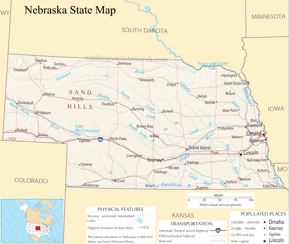
A large detailed map of Nebraska State
This is a large, detailed map of Nebraska. There are links to many Nebraska localities below.
View our Nebraska State county map
from the National Atlas of the United States
United States Department of the Interior
Nebraska State Map
Explore Nebraska with an interactive map featuring Street View, satellite and terrain views. Live weather, local news and location details for Nebraska — plus links to detailed street maps for 591 cities and towns across the state.
Map search is available for a limited number of queries per session to manage costs. Be specific — search precisely for best results.
| State | Nebraska (NE) |
| Capital | Lincoln |
| Largest City | Omaha |
| Country | United States |
| Latitude | 41.2058 |
| Longitude | -98.3165 |
| Population | 1,961,504 |
| Cities & Towns | 591 |
About Nebraska
Nebraska unfolds as a vast expanse of rolling prairies and fertile plains, a landscape sculpted by wind and water over millennia. The land here is predominantly flat to gently undulating, reaching its highest elevations in the west with the Pine Ridge Escarpment and the Sandhills, a unique ecosystem of grass-stabilized sand dunes. While Nebraska boasts no coastlines, its lifeblood flows through major rivers like the Platte, the Niobrara, and the Missouri, which forms its eastern border, nourishing the rich farmlands. The climate is continental, characterized by hot summers and cold, snowy winters, fostering a distinct rhythm of seasons across the state. Natural landmarks include the dramatic formations of Scotts Bluff National Monument and the tranquil beauty of Niobrara State Park, offering glimpses into Nebraska's untamed spirit.
The story of Nebraska is deeply interwoven with the ancient peoples who first called this land home, their presence felt in the enduring spirit of the plains. European settlers later arrived, drawn by the promise of fertile soil and westward expansion, forever altering the demographic and physical fabric of Nebraska. Achieving statehood in 1867, Nebraska began its journey as a young state, gradually shaping its identity through hard work and a profound connection to the land. The subsequent decades saw waves of immigration, contributing to the diverse cultural tapestry that defines contemporary Nebraska, a testament to resilience and the enduring pursuit of opportunity.
The economic engine of Nebraska is powerfully driven by its agricultural prowess, with vast fields of corn, soybeans, and wheat stretching as far as the eye can see. This agrarian foundation supports robust industries in food processing and biofuels, while a growing manufacturing sector contributes significantly to the state's prosperity. Major cities like Omaha and Lincoln serve as vibrant hubs for finance, technology, and services, fostering innovation and providing essential infrastructure for commerce. Regional centers across Nebraska play crucial roles in supporting agricultural communities and facilitating the distribution of goods and resources, ensuring a balanced economic landscape.
The cultural heart of Nebraska beats with a quiet pride, a reflection of the hardworking people and the enduring traditions that define daily life. While professional sports leagues are not directly represented within Nebraska, the state's passion for athletics burns brightly through its dedicated college sports programs, particularly in football, where a fervent fanbase is legendary. Annual events like the Nebraska State Fair celebrate the state's agricultural heritage and community spirit, drawing crowds from across the region. The cuisine often features hearty, farm-fresh ingredients, embodying the down-to-earth character of Nebraska's people, who find beauty in the golden light of sunset over endless fields.
Nebraska City and Town Maps
A
B
C
D
E
F
G
H
L
M
N
O
P
R
S
T
W
Y
Nebraska Maps — Interactive Map, Street View, Weather & News
This page provides an interactive Google map of Nebraska (NE) with Street View, satellite and terrain views, alongside links to detailed street maps for 591 cities and towns across the state. The state capital is Lincoln and the largest city is Omaha, with a state population of approximately 1,961,504.
Each city and town map page includes an embedded street and satellite map. Live weather where available combines National Weather Service forecasts with Open-Meteo graphical data including hourly and 7-day outlooks. Local and world news, Wikipedia location summaries, and precise GPS coordinates are included where available.
Location data is sourced from the USGS GNIS database and verified by coordinates, not name matching alone.