A large detailed map of New Hampshire State
This is a large, detailed map of New Hampshire. There are links to many New Hampshire localities below. Our website format reduces the display size for uniformity. Here is a link to the full-size image that is more easily readable.
View our New Hampshire State county map
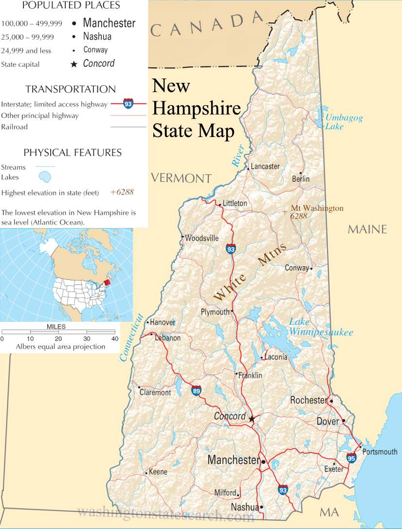
from the National Atlas of the United States
United States Department of the Interior
New Hampshire State Map
Explore New Hampshire with an interactive map featuring Street View, satellite and terrain views. Live weather, local news and location details for New Hampshire — plus links to detailed street maps for 95 cities and towns across the state.
Map search is available for a limited number of queries per session to manage costs. Be specific — search precisely for best results.
| State | New Hampshire (NH) |
| Capital | Concord |
| Largest City | Manchester |
| Country | United States |
| Latitude | 43.452492 |
| Longitude | -71.563896 |
| Population | 1,377,529 |
| Cities & Towns | 95 |
New Hampshire rises from a brief, salt-scented Atlantic frontage, where the jagged shoreline gives way to a sprawling interior dominated by the rugged spine of the White Mountains. Great rivers, fed by the slow melt of winter snows, carve deep, cold channels through the earth, drawing water from the northern forests down toward the sea. The geography is defined by a persistent, unyielding gray stone that breaks the surface of the soil, forcing the land to hold its shape against the elements. In the northern reaches, the terrain ascends into vast, shadowed wilderness, while the central districts gather around deep, glacial basins that hold the sky in their dark, still surfaces. As the sun dips low, the granite peaks catch a fading, bruised light, turning the horizon into a serrated edge that seems to hold the very air in place.
Indigenous nations lived along these waterways for generations, fishing the runs of salmon and navigating the corridors of pine before the first European travelers arrived to map the coastline and venture inland. The early colonial period brought a slow, deliberate settlement, as families cleared rocky pastures and built stone walls that still trace the boundaries of forgotten fields. New Hampshire occupied a volatile position during the colonial conflicts, serving as a frontier buffer where the struggle for territory was marked by the hard labor of building permanent homesteads. By the time the state helped frame the early American government, the character of its people had been forged by the necessity of survival in a climate that demanded both foresight and a stubborn independence.
Economic life has long been dictated by the state’s raw materials and the ingenuity required to harness them. Historically, the swift descent of the rivers powered the mills that turned out textiles and paper, creating industrial centers that thrived on the sheer force of the current. Agriculture here is a quiet defiance, with farmers tending to orchards and sugar maples that endure long, biting winters to yield their syrup in the spring. Today, the economy has shifted toward precision manufacturing and technology, yet it remains tethered to the traditional reliance on forest products and a seasonal tourism that ebbs and flows with the turning leaves. There is a particular weight to the silence of a defunct mill at dusk, a sense that the machinery of the past is merely waiting, caught in the pause between the bustle of the day and the encroaching frost.
Cultural life in New Hampshire moves at the pace of a slow-burning hearth, favoring a guarded privacy that respects the boundaries of one’s neighbor. Literature often reflects this solitude, capturing the interior lives of people who find meaning in the repetition of seasons and the maintenance of their own small properties. Sports are less about the spectacle of the arena and more about the individual’s engagement with the landscape, whether through the quiet focus of winter skiing or the solitary pursuit of hiking through high-altitude scrub. The food is utilitarian and honest, rooted in the harvest of the region, while the voice of the state carries a clipped, deliberate cadence. It is a place where the air feels thin and sharp, clarifying the mind and reminding the traveler that life is sustained not by grand gestures, but by the steady, repetitive work of tending to the ground beneath one's feet.
New Hampshire City and Town Maps
B
C
E
G
M
N
P
W
New Hampshire Maps — Interactive Map, Street View, Weather & News
This page provides an interactive Google map of New Hampshire (NH) with Street View, satellite and terrain views, alongside links to detailed street maps for 95 cities and towns across the state. The state capital is Concord and the largest city is Manchester, with a state population of approximately 1,377,529.
Each city and town map page includes an embedded street and satellite map. Live weather where available combines National Weather Service forecasts with Open-Meteo graphical data including hourly and 7-day outlooks. Local and world news, Wikipedia location summaries, and precise GPS coordinates are included where available.
Location data is sourced from the USGS GNIS database and verified by coordinates, not name matching alone.
