A large detailed map of New Jersey State
This is a large, detailed map of New Jersey. There are links to many New Jersey localities below. Our website format reduces the display size for uniformity. Here is a link to the full-size image that is more easily readable.
View our New Jersey State county map
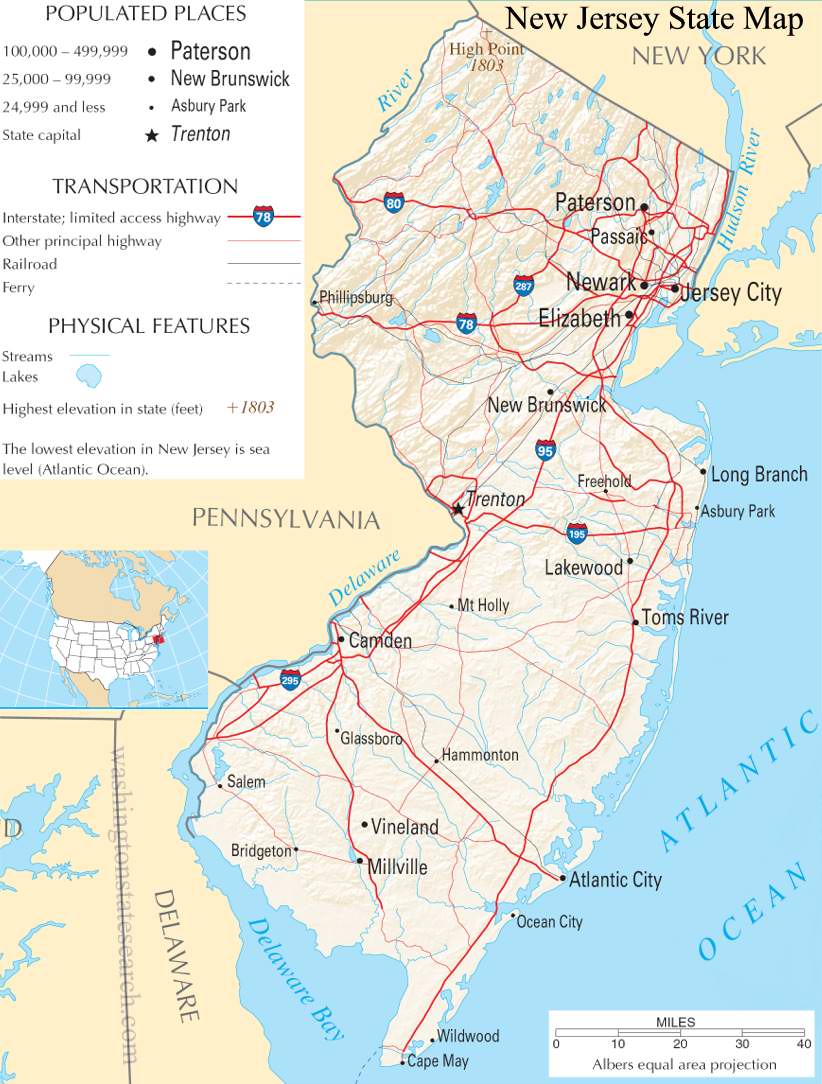
from the National Atlas of the United States
United States Department of the Interior
New Jersey State Map
Explore New Jersey with an interactive map featuring Street View, satellite and terrain views. Live weather, local news and location details for New Jersey — plus links to detailed street maps for 899 cities and towns across the state.
Map search is available for a limited number of queries per session to manage costs. Be specific — search precisely for best results.
| State | New Jersey (NJ) |
| Capital | Trenton |
| Largest City | Newark |
| Country | United States |
| Latitude | 40.298904 |
| Longitude | -74.521011 |
| Population | 9,288,994 |
| Cities & Towns | 899 |
New Jersey spans a remarkable topographical range, defined by the tidal gravity of its flanking rivers and the long, restless edge of the Atlantic. To the north, the Appalachian ridges fold into deep, shadowed valleys, while the central corridor transitions into a low-slung expanse of marshland and meadow that seems to hold the light longer at dusk, turning the tall grasses into a pale, bruised gold. Further south, the terrain flattens into the sandy, acidic soil of the Pine Barrens, a vast, silent wilderness of scrub oak and pitch pine where the air tastes of resin and damp earth. This geography creates a natural friction; the state is a corridor of movement, squeezed between the major metropolitan centers that define its boundaries, yet possessing a rugged, interior stillness that persists despite the encroaching pace of the coast.
Indigenous Lenape populations long occupied these river valleys and shorelines, cultivating a deep knowledge of the seasonal cycles of the Delaware and the coastal estuaries before European explorers arrived to claim the territory for Dutch and Swedish interests. British governance eventually took hold, turning the region into a contested theater during the Revolution, where the winter chill and the shifting loyalties of the population tested the resolve of an emerging nation. New Jersey became a crucible for early industrial experimentation, its ports and waterways serving as the primary conduits for goods moving toward the interior. The legacy of this era remains etched into the brickwork of older mill towns and the grid of narrow, steep streets where the architecture still reflects the utilitarian urgency of early American commerce.
Agriculture and industry have long shared a complicated, often overlapping life here, creating a landscape that produces both high-tech pharmaceuticals and vast harvests of blueberries, cranberries, and tomatoes. The state’s economy has always functioned as a high-pressure engine, transitioning from the raw production of iron and textiles to the refined labor of research laboratories and global logistics. In the fields during the harvest, one can still see the distinct, dusty quality of the sunlight hitting the furrows, a sight that feels older than the surrounding highways. This industrial history has fostered a culture of extreme precision and grit, where the value of a day’s work is measured by the tangible output of the factory floor or the meticulous care given to the rows of vegetables that define the rural southern counties.
Cultural life in New Jersey is defined by a particular, restless cadence, a blend of the boardwalk’s neon-lit urgency and the quiet, suburban density that characterizes the lives of its millions of residents. The state’s voice is heard in the poetry of its industrial ruins and the driving, percussive rhythm of its music, which often captures the tension between the desire to leave and the pull of the neighborhood. Sports, whether played on the manicured turf of collegiate fields or in the crowded arenas of the professional leagues, command a fierce, uncompromising loyalty. In the evening, when the heat finally lifts from the asphalt, the air holds a specific, heavy moisture that carries the scent of the nearby ocean, reminding those who live here that they are always tethered to the sea, even when they are miles inland, caught in the persistent motion of the American road.
New Jersey City and Town Maps
A
B
C
D
E
F
G
H
I
J
K
L
M
N
O
P
R
S
T
U
V
W
New Jersey Maps — Interactive Map, Street View, Weather & News
This page provides an interactive Google map of New Jersey (NJ) with Street View, satellite and terrain views, alongside links to detailed street maps for 899 cities and towns across the state. The state capital is Trenton and the largest city is Newark, with a state population of approximately 9,288,994.
Each city and town map page includes an embedded street and satellite map. Live weather where available combines National Weather Service forecasts with Open-Meteo graphical data including hourly and 7-day outlooks. Local and world news, Wikipedia location summaries, and precise GPS coordinates are included where available.
Location data is sourced from the USGS GNIS database and verified by coordinates, not name matching alone.
