A large detailed map of New Mexico State
This is a large, detailed map of New Mexico. There are links to many New Mexico localities below. Our website format reduces the display size for uniformity. Here is a link to the full-size image that is more easily readable.
View our New Mexico State county map
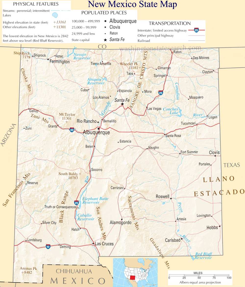
from the National Atlas of the United States
United States Department of the Interior
New Mexico State Map
Explore New Mexico with an interactive map featuring Street View, satellite and terrain views. Live weather, local news and location details for New Mexico — plus links to detailed street maps for 478 cities and towns across the state.
Map search is available for a limited number of queries per session to manage costs. Be specific — search precisely for best results.
| State | New Mexico (NM) |
| Capital | Santa Fe |
| Largest City | Albuquerque |
| Country | United States |
| Latitude | 34.840515 |
| Longitude | -106.248482 |
| Population | 2,117,522 |
| Cities & Towns | 478 |
New Mexico stretches across a vast expanse of high-altitude basin and range, where the earth seems to hold the heat of the sun long after the light has retreated into violet shadows. The Rio Grande acts as a central artery, bisecting the landscape as it carves a path through volcanic basalt and ancient alluvial plains. To the north, the Sangre de Cristo Mountains rise with jagged, snow-dusted authority, their slopes shaded by dense stands of ponderosa pine that scent the air with resin. Further south, the terrain flattens into the stark, gypsum-white dunes that shift incrementally with the wind, a silent sea of minerals under a sky so expansive it renders the horizon a mere suggestion. In the cool of the evening, the air possesses a peculiar, thin clarity that makes distant peaks appear close enough to touch, a quality of atmosphere that has long compelled observers to pause and consider the sheer scale of the horizon.
Indigenous nations have occupied these river valleys and mesas for millennia, building complex communal architectures that predate any European arrival. The subsequent arrival of Spanish explorers introduced a colonial architecture of adobe and timber, creating a layered society where Hispano and Indigenous traditions began to influence one another, often in uneasy but enduring proximity. This territory transitioned through various administrative hands, from the Spanish Crown to the Mexican Republic, before finally becoming a territory and later a state within the American union. The historical weight of these shifts is visible in the stubborn preservation of old irrigation ditches, known as acequias, which continue to channel water through village fields just as they did centuries ago. It is a history defined by the persistence of small, isolated communities that maintained their own languages and customs despite the encroaching pressures of a modernizing world.
Agriculture and resource extraction have long formed the bedrock of the economy, beginning with the dry-land farming of corn and beans and evolving into the massive, sun-drenched chile fields that turn brilliant red in the autumn harvest. Beneath the surface, the state has contributed significantly to the nation’s energy needs, from coal and natural gas to the complex scientific research that emerged in the mid-twentieth century. This dual identity—the quiet, labor-intensive work of the soil and the high-stakes precision of laboratories—creates a strange friction in the daily life of the state. One might drive past a field where laborers are picking crops under a relentless noon sun, only to arrive at a high-tech facility tasked with navigating the frontiers of physics. This economic duality ensures that the state remains tethered to the physical labor of the land even while it plays a role in the most abstract reaches of modern industry.
Cultural identity here is a slow-accumulating sediment of song, literature, and culinary tradition. The local palate is defined by the heat of the chile, a flavor so integral to the regional character that it serves as a common language across disparate social circles. Writers and painters have frequently been drawn to the state by the quality of the light, which possesses a sharp, crystalline intensity that strips away artifice and exposes the raw edges of the landscape. Life moves at a pace determined more by the seasonal availability of water and the long, slow migration of the seasons than by the frantic ticking of a clock. In the quiet hours of a Sunday morning, when the scent of woodsmoke drifts from the kiva fireplaces, one senses that the people here exist in a deliberate, measured relationship with their surroundings, valuing the endurance of their specific, sun-baked corner of the world above all else.
New Mexico City and Town Maps
A
B
C
D
E
F
G
H
I
J
K
L
M
N
O
P
R
S
T
V
W
New Mexico Maps — Interactive Map, Street View, Weather & News
This page provides an interactive Google map of New Mexico (NM) with Street View, satellite and terrain views, alongside links to detailed street maps for 478 cities and towns across the state. The state capital is Santa Fe and the largest city is Albuquerque, with a state population of approximately 2,117,522.
Each city and town map page includes an embedded street and satellite map. Live weather where available combines National Weather Service forecasts with Open-Meteo graphical data including hourly and 7-day outlooks. Local and world news, Wikipedia location summaries, and precise GPS coordinates are included where available.
Location data is sourced from the USGS GNIS database and verified by coordinates, not name matching alone.
