A large detailed map of North Carolina State
This is a large, detailed map of North Carolina. There are links to many North Carolina localities below. Our website format reduces the display size for uniformity. Here is a link to the full-size image that is more easily readable.
View our North Carolina State county map
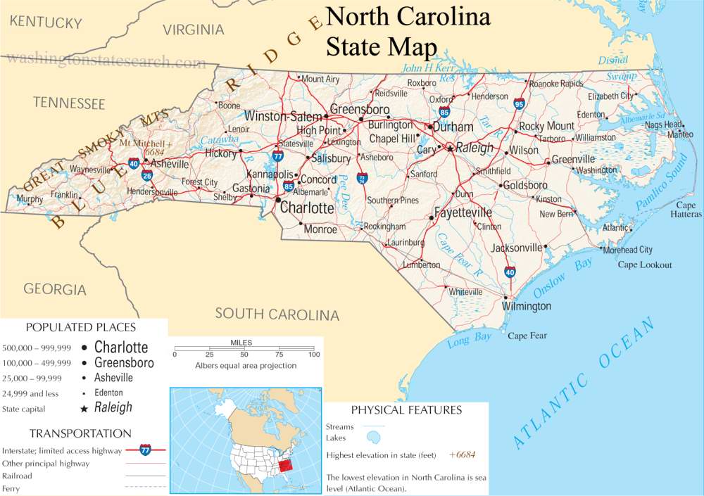
from the National Atlas of the United States
United States Department of the Interior
North Carolina State Map
Explore North Carolina with an interactive map featuring Street View, satellite and terrain views. Live weather, local news and location details for North Carolina — plus links to detailed street maps for 790 cities and towns across the state.
Map search is available for a limited number of queries per session to manage costs. Be specific — search precisely for best results.
| State | North Carolina (NC) |
| Capital | Raleigh |
| Largest City | Charlotte |
| Country | United States |
| Latitude | 35.630066 |
| Longitude | -79.806419 |
| Population | 10,439,388 |
| Cities & Towns | 790 |
North Carolina descends from the jagged, ancient spine of the Appalachian range, where the air grows thin and cold against the granite, down through the broad, red-clay plateau of the piedmont, and finally to the low, shifting sands of the Atlantic shore. The rivers here—the Catawba, the Yadkin, the Neuse—do not merely flow; they carve through the geography like arteries, feeding a landscape that shifts from the mist-heavy forests of the west to the salt-scrubbed barrier islands that stand guard against the ocean. In the high country, the light at dusk has a way of lingering, turning the mountain peaks a deep, bruised violet, while toward the coast, the horizon flattens until the sky seems to press down with the weight of the coming tide. It is a terrain of stark transitions, where the humidity of a summer evening can feel as thick as wool, settling over the pine barrens and the swampy lowlands with a persistent, quiet gravity.
Indigenous nations, including the Cherokee, the Tuscarora, and the Catawba, shaped the earliest paths through these dense thickets long before European explorers arrived to map the jagged coastline. The state grew through a hard-won process of colonial expansion, becoming a site of pivotal Revolutionary resolve and later, the site of deep, painful divisions during the Civil War. These formative centuries left a residue in the earth, a sense that the soil holds the memory of every plowshare and musket ball it has absorbed. North Carolina emerged not as a monolith, but as a collection of stubborn, localized identities defined by the necessity of survival. The old stone chimneys that remain standing in the deep woods serve as silent markers of families who once cleared the brush by hand, living in a quiet, fragile isolation that defined the early character of the frontier.
Agriculture and industry have long dictated the pace of life here, moving from the labor-intensive cultivation of tobacco and cotton to the modern, high-tech corridors where research and medicine now lead the way. For generations, the texture of the state was defined by the coarse fiber of textiles and the scent of curing leaves hanging in wooden barns, a rhythm of work that mirrored the growing seasons. Now, the economy finds its pulse in the laboratory and the university, though the legacy of the agrarian past remains in the way a person might still measure the success of a year by the health of the fields or the yield of the local harvest. It is a place that understands the value of a tangible product, whether it is a piece of fine-tuned machinery or a crate of sweet potatoes pulled from the earth, and there is a lingering respect for the hand that does the work.
Cultural life here is defined by a distinct auditory and sensory landscape, from the high, lonely lilt of the Appalachian ballad tradition to the sharp, roaring exhaust of stock car racing that echoes through the southern heat. The culinary divide is a matter of fierce devotion, with the vinegar-based tang of eastern barbecue standing in stark contrast to the tomato-inflected, slow-cooked traditions of the west, a debate that remains a cornerstone of social life. In the evenings, the voice of the state softens, carrying a courteous, measured cadence that favors patience over haste. Whether in the fervor surrounding collegiate sports or the quiet study of regional novelists, there is a commitment to the particular—a belief that a story, a meal, or a game is best understood when it is grounded in the specific, unvarnished reality of the neighborhood where it began.
North Carolina City and Town Maps
A
B
C
D
E
F
G
H
I
J
K
L
M
N
O
P
R
S
T
V
W
North Carolina Maps — Interactive Map, Street View, Weather & News
This page provides an interactive Google map of North Carolina (NC) with Street View, satellite and terrain views, alongside links to detailed street maps for 790 cities and towns across the state. The state capital is Raleigh and the largest city is Charlotte, with a state population of approximately 10,439,388.
Each city and town map page includes an embedded street and satellite map. Live weather where available combines National Weather Service forecasts with Open-Meteo graphical data including hourly and 7-day outlooks. Local and world news, Wikipedia location summaries, and precise GPS coordinates are included where available.
Location data is sourced from the USGS GNIS database and verified by coordinates, not name matching alone.
