A large detailed map of North Dakota State Counties
Explore North Dakota with an interactive map featuring Street View, satellite and terrain views. Browse all 53 counties of North Dakota below, with links to every city and town map page. Live weather and local news are included on every location page.
View our North Dakota State map
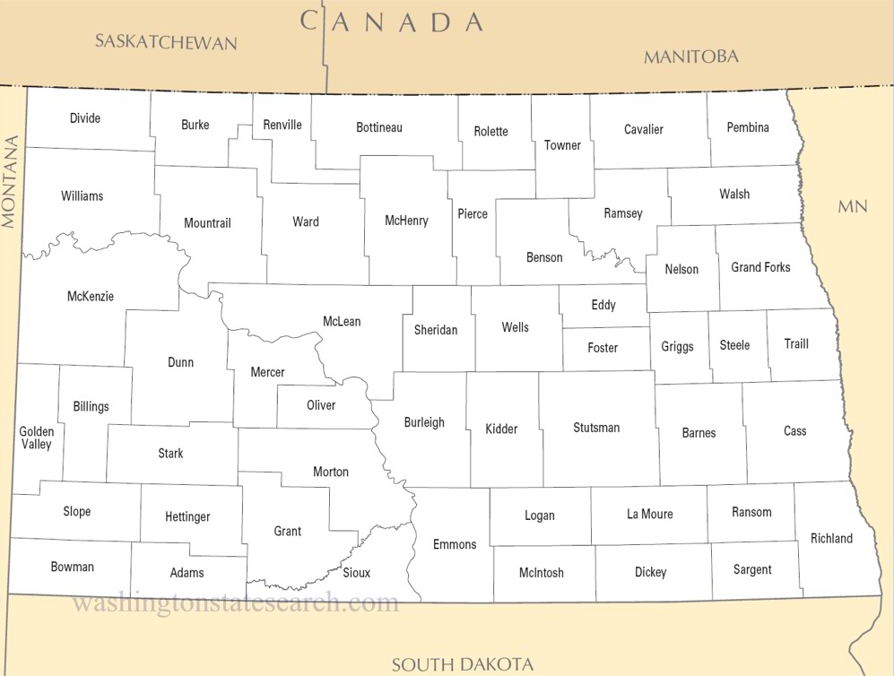
from the National Atlas of the United States
United States Department of the Interior
North Dakota State Map
Map search is available for a limited number of queries per session to manage costs. Be specific — search precisely for best results.
| State | North Dakota |
| Capital | Bismarck |
| Country | United States of America |
| Counties | 53 |
| Latitude | 47.528912 |
| Longitude | -99.784012 |
| Cities & Towns | 403 |
| State Map | North Dakota Maps |
About North Dakota
North Dakota occupies a vast expanse where the earth flattens into the ancient, sun-bleached floor of a glacial lake before rising sharply into the fractured, color-streaked drama of the badlands. The Red River marks the eastern boundary, carving a fertile trough through the silt of a vanished sea, while the Missouri River bisects the state, pulling the landscape toward the western high plains. Here, the horizon possesses a predatory quality, a wide and indifferent arc that humbles whatever stands beneath it. When the light shifts at dusk, the prairie grasses turn the color of hammered copper, and the atmosphere thins until the distance between the eye and the stars feels perilously short. This is a geography of extremes, where the wind acts as a persistent sculptor, scouring the gray clay of the canyons and pushing the shadows of clouds across miles of unbroken, emerald-colored wheat.
Indigenous nations, primarily the Mandan, Hidatsa, Arikara, and the various bands of the Oceti Sakowin, held these territories long before the arrival of fur traders and the eventual surge of homesteaders who sought to break the sod with steel plows. The transition into statehood arrived during an era of rail expansion and federal land distribution, creating a mosaic of farmsteads that mirrored the ethnic origins of those arriving from Northern Europe. These early settlers contended with a climate that demanded a stoic, almost glacial patience, forging a society defined by a hard-won self-reliance. North Dakota preserves the echoes of these formative struggles in the quietude of its rural cemeteries and the stark, timber-frame skeletons of abandoned barns that lean into the prevailing northwest wind, holding their ground against the slow erosion of memory.
Agriculture remains the primary pulse of the state, with the soil yielding vast harvests of spring wheat, canola, and sunflowers that turn their heavy heads in unison toward the sun. Below the surface, the industrial extraction of crude oil from the deep geological layers of the Bakken formation has fundamentally altered the state’s economic trajectory, injecting a volatile, high-stakes energy into the quiet machinery of farm life. This duality—the slow, seasonal labor of the soil and the frantic, mechanical hum of the rigs—creates a friction that defines the modern North Dakota experience. It is a place where one might pass a field of flax, blue as a summer sky, only to encounter the industrial silhouette of a flare stack burning brightly in the dark, a reminder that the prosperity of the region is pulled directly from the hidden, pressurized depths of the earth.
Cultural life here is defined by a deep, understated sociability, often centered on the shared warmth of an indoor rink or the communal focus of a local high school gymnasium. The cuisine leans toward the hearty and the starch-heavy, reflecting the need for fuel against the bitter, bone-deep cold of a mid-winter night. Literature and music in the region often grapple with the weight of isolation, finding beauty in the stark, monochromatic stretches of a winter landscape where the snow drifts into intricate, wind-whipped geometries. Life here moves at the pace of a slow thaw, and the residents possess a manner of speaking that is clipped and cautious, reserving their deeper thoughts for those who have sat long enough to earn them. It is a quiet existence, governed by the rhythm of the seasons and the realization that, in a land this wide, the most important work is often done in the company of a few trusted neighbors.
North Dakota Cities and Towns by County
Cass County
McLean County
Richland County
Rolette County
Stutsman County
North Dakota County Maps & Location Information
This page provides an interactive Google map of North Dakota (ND) with Street View, satellite and terrain views, alongside links to detailed street maps for all 403 cities and towns across the state organised by county. North Dakota has 53 counties, with the state capital at Bismarck.
Every locality page includes an embedded street and satellite map alongside live weather where available — combining National Weather Service forecasts with Open-Meteo graphical data including hourly observations and 7-day outlooks. Local and world news feeds, Wikipedia summaries and editorially written descriptions are included where available.
Location data is sourced from the USGS GNIS database and the SimpleMaps US Cities dataset, verified by coordinates rather than name matching alone.
