A large detailed map of Oklahoma State
This is a large, detailed map of Oklahoma. There are links to many Oklahoma localities below. Our website format reduces the display size for uniformity. Here is a link to the full-size image that is more easily readable.
View our Oklahoma State county map
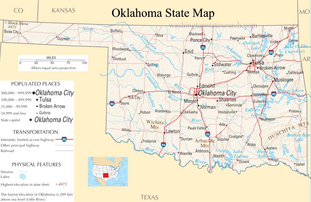
from the National Atlas of the United States
United States Department of the Interior
Oklahoma State Map
Explore Oklahoma with an interactive map featuring Street View, satellite and terrain views. Live weather, local news and location details for Oklahoma — plus links to detailed street maps for 824 cities and towns across the state.
Map search is available for a limited number of queries per session to manage costs. Be specific — search precisely for best results.
| State | Oklahoma (OK) |
| Capital | Oklahoma City |
| Largest City | Oklahoma City |
| Country | United States |
| Latitude | 35.565342 |
| Longitude | -96.928917 |
| Population | 3,959,353 |
| Cities & Towns | 824 |
Oklahoma occupies a geological transition zone where the humid forests of the east surrender to the arid, high-plains expanse of the west. The landscape shifts from the rugged, forested peaks of the Ouachita Mountains—where the air holds a cool, pine-scented density even in midsummer—to the broad, flat reaches of the panhandle, where the horizon seems to stretch until the earth curves away. The state is dissected by the Arkansas and Red Rivers, which carry the sediment of the high plains toward the Mississippi, carving deep, red-clay channels through the scrubby, twisted oaks of the Cross Timbers. At dusk, the light here possesses a peculiar, bruised quality, casting long, violet shadows across the red dirt that make the land appear as if it is exhaling the heat of the day.
Oklahoma remains a place defined by the forced convergence of diverse Indigenous nations and the subsequent pressures of westward expansion. Following the displacement of the Cherokee, Choctaw, Osage, Comanche, and many others, the region functioned as an enforced refuge before the land runs fractured the territory into homesteads. The transition to statehood was marked by a collision of cultures, leaving a legacy that is neither purely Southern nor entirely Western, but a distinct synthesis of trauma and resilience. The memory of the Indian Territory is not a static relic but a living influence, visible in the sovereign governance of the nations that persist today, their presence grounding the state in a history that long predates the arrival of the rail lines.
Economic life in Oklahoma has been dictated by the volatility of the earth itself, moving from the labor of the wheat harvest to the boom-and-bust cycles of the petroleum industry. The landscape is punctuated by the skeletal silhouettes of oil derricks, relics of a time when the black gold beneath the surface promised sudden fortunes and changed the trajectory of the economy forever. In the west, the economy remains tethered to the rhythm of the seasons, with massive combines harvesting grain across fields that shimmer like a mirage under the relentless sun. This industry has fostered a culture of self-reliance, where the grit of manual labor and the specialized knowledge of the energy sector form the bedrock of daily existence, turning the raw resources of the soil into the fuel that powers the national machinery.
Cultural expression in Oklahoma emerges from a quiet, internal intensity, often finding its voice in the spaces between the vast, open stretches of prairie. Sports, particularly collegiate football, provide a communal focus that organizes the calendar, turning autumn Saturdays into a shared, fervent ritual that transcends neighborhood boundaries. The music of the state—a blend of gospel, blues, and red dirt country—reflects the texture of the life lived here, favoring stories of displacement, hard work, and the persistent pull of home. Whether it is the taste of a savory meat pie or the understated pride of a local high school basketball game, the pace of life maintains a deliberate steadiness. It is a place where people navigate the vastness of their surroundings with a grounded, unpretentious clarity, finding beauty in the way the wind sweeps unobstructed across miles of grass, indifferent to the structures men have built upon it.
Oklahoma City and Town Maps
A
B
C
D
E
F
G
H
K
L
M
N
O
P
R
S
T
U
V
W
Oklahoma Maps — Interactive Map, Street View, Weather & News
This page provides an interactive Google map of Oklahoma (OK) with Street View, satellite and terrain views, alongside links to detailed street maps for 824 cities and towns across the state. The state capital is Oklahoma City and the largest city is Oklahoma City, with a state population of approximately 3,959,353.
Each city and town map page includes an embedded street and satellite map. Live weather where available combines National Weather Service forecasts with Open-Meteo graphical data including hourly and 7-day outlooks. Local and world news, Wikipedia location summaries, and precise GPS coordinates are included where available.
Location data is sourced from the USGS GNIS database and verified by coordinates, not name matching alone.
