A large detailed map of Oregon State
This is a large, detailed map of Oregon. There are links to many Oregon localities below. Our website format reduces the display size for uniformity. Here is a link to the full-size image that is more easily readable.
View our Oregon State county map
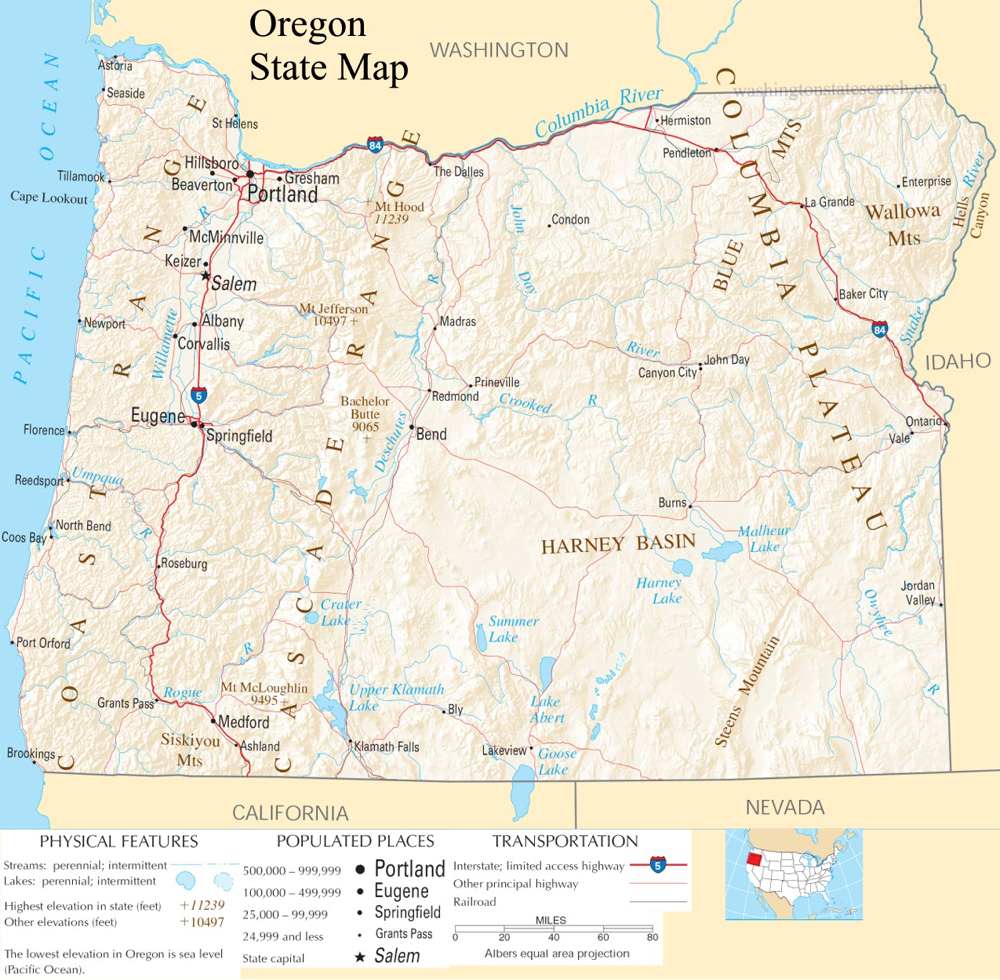
from the National Atlas of the United States
United States Department of the Interior
Oregon State Map
Explore Oregon with an interactive map featuring Street View, satellite and terrain views. Live weather, local news and location details for Oregon — plus links to detailed street maps for 412 cities and towns across the state.
Map search is available for a limited number of queries per session to manage costs. Be specific — search precisely for best results.
| State | Oregon (OR) |
| Capital | Salem |
| Largest City | Portland |
| Country | United States |
| Latitude | 44.572021 |
| Longitude | -122.070938 |
| Population | 4,237,256 |
| Cities & Towns | 412 |
Oregon defines itself through a jagged geological partition, where the Cascade Range acts as a monumental spine, dividing the humid, evergreen-choked western slope from the arid, volcanic plateaus of the interior. To the west, the Pacific Ocean claws at a shoreline of gray basalt and sea-stack monoliths, where the air remains heavy with the scent of salt spray and rotting cedar. The rivers here do not merely flow; they rush with a cold, insistent urgency toward the sea, cutting through deep canyons lined with ferns and moss that seem to hold the shadows even at high noon. Across the mountains, the landscape shifts into high desert, a place of sagebrush and wide, punishing skies where the horizon stretches so far that the light at dusk turns the earth into a bruised, violet-colored expanse. It is a land of sharp contrasts, where the persistent moisture of the coast gives way to the brittle, sun-scorched silence of the interior, creating a geography that demands a certain rugged adaptability from everything that lives upon it.
Indigenous nations have long navigated these river corridors and mountain passes, their presence etched into the oral traditions and the very soil of the river basins long before the arrival of maritime explorers and fur traders. Oregon became a destination for thousands of families who moved west along the dusty, perilous ruts of the overland trails, seeking a permanence that the frontier rarely granted. This migration changed the demographic landscape, as timber camps and homesteads sprouted in the clearings of the old-growth forests, often at the expense of the people who had lived there for millennia. Statehood arrived in the middle of the nineteenth century, formalizing an identity built on isolation and the slow, grinding process of clearing land. The history of the state is not a smooth progression, but a series of hard-won settlements and labor movements that sought to tame a wilderness that was never truly interested in being domesticated.
Agriculture and industry here have always been tied to the extraction and cultivation of the earth’s raw bounty. In the valleys, the soil is dark and deep, providing a home for vineyards that produce pinot noir of a distinct, earthy character, while the high desert regions support cattle ranches and fields of grain. Historically, the economy relied heavily on the timber industry, with sawmills forming the pulse of many small settlements where the daily whistle dictated the rhythm of human activity. Today, the state has diversified into complex manufacturing and technological sectors, yet the connection to the land remains visceral; the fiber of the economy is still largely dictated by what can be harvested from the forests, the orchards, or the mineral-rich earth. There is a quiet, industrious pride in this production, a recognition that the prosperity of Oregon is tethered to the health of its timber stands and the seasonal cycles of its harvest.
Cultural life in Oregon moves with a deliberate, unassuming pace, often favoring the quiet observation of the natural world over the frantic clamor of urban centers. The literary output of the region frequently mirrors the damp, introspective climate, focusing on the intersection of human fragility and the overwhelming scale of the surrounding wilderness. Music and food scenes are similarly unpretentious, relying on local ingredients and a collaborative spirit that avoids the polished sheen of more commercial centers. On autumn Saturdays, the obsession with collegiate sports transforms the atmosphere into a singular, frantic fervor, a brief departure from the typical, measured demeanor of the populace. Whether watching a game under a leaden, drizzling sky or sitting in a dimly lit tavern as the rain taps against the glass, one senses a distinct regional voice—a quiet, grounded perspective that finds beauty in the mundane details of a life lived on the edge of a vast, indifferent frontier.
Oregon City and Town Maps
A
B
C
D
E
F
G
H
I
J
K
L
M
N
O
P
R
S
T
W
Oregon Maps — Interactive Map, Street View, Weather & News
This page provides an interactive Google map of Oregon (OR) with Street View, satellite and terrain views, alongside links to detailed street maps for 412 cities and towns across the state. The state capital is Salem and the largest city is Portland, with a state population of approximately 4,237,256.
Each city and town map page includes an embedded street and satellite map. Live weather where available combines National Weather Service forecasts with Open-Meteo graphical data including hourly and 7-day outlooks. Local and world news, Wikipedia location summaries, and precise GPS coordinates are included where available.
Location data is sourced from the USGS GNIS database and verified by coordinates, not name matching alone.
