A large detailed map of South Carolina State Counties
Explore South Carolina with an interactive map featuring Street View, satellite and terrain views. Browse all 46 counties of South Carolina below, with links to every city and town map page. Live weather and local news are included on every location page.
View our South Carolina State map
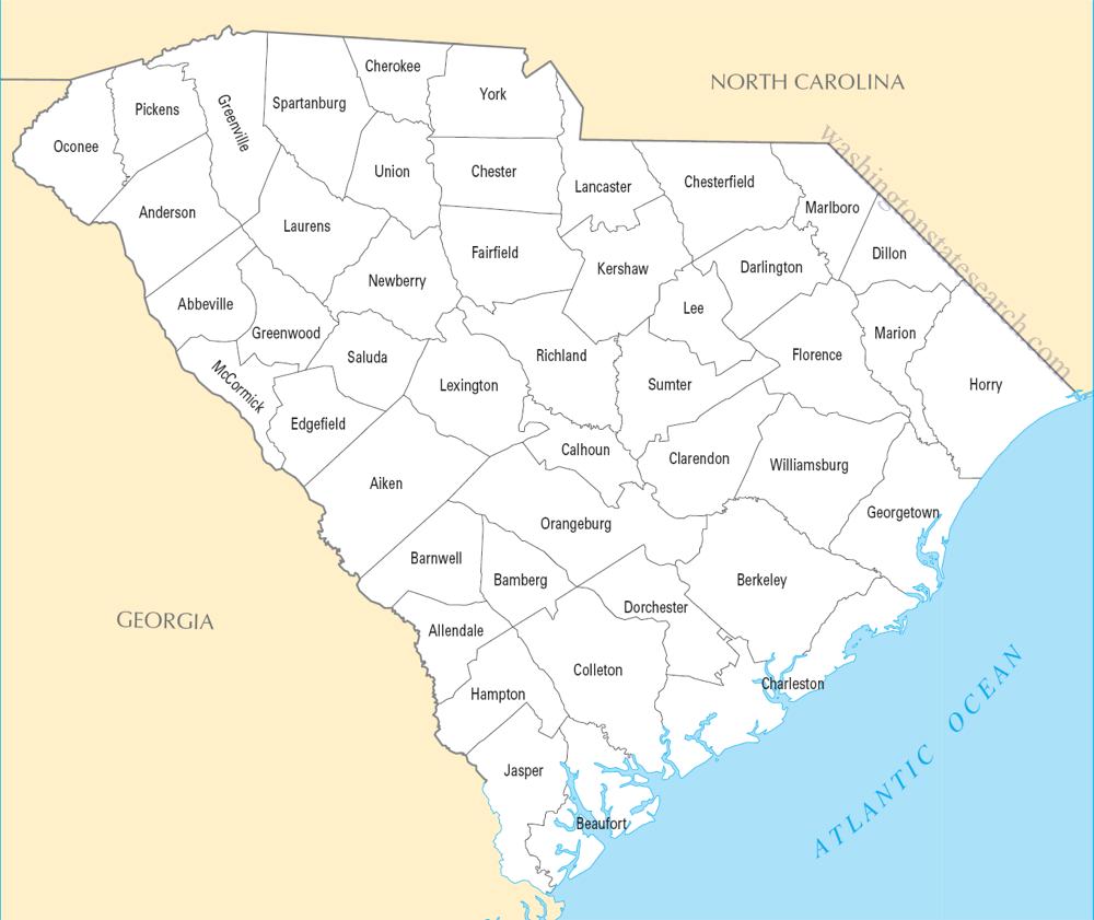
from the National Atlas of the United States
United States Department of the Interior
South Carolina State Map
Map search is available for a limited number of queries per session to manage costs. Be specific — search precisely for best results.
| State | South Carolina |
| Capital | Columbia |
| Country | United States of America |
| Counties | 46 |
| Latitude | 33.856892 |
| Longitude | -80.945007 |
| Cities & Towns | 422 |
| State Map | South Carolina Maps |
About South Carolina
South Carolina descends from the Blue Ridge Mountains in the northwest, where the air grows thin and cool against the granite, before spilling out into the broad, red-clay expanse of the piedmont. Here, the rivers—the Savannah, the Santee, the Congaree—carve deep, winding paths through the landscape, acting as arteries that feed the low-lying plains. As the terrain levels, the pine forests surrender to the vast, tidal marshes of the coast, where the water is dark and brackish and the horizon is often lost in a haze of salt spray. In the late afternoon, the light turns a bruised violet over the tidal creeks, and the sawgrass seems to hold the heat of the day long after the sun has retreated behind the maritime canopy.
Indigenous nations, including the Catawba and the Yamasee, shaped the early contours of the land long before European ships appeared off the sandbars of the Atlantic. The arrival of settlers brought a complex and often brutal transformation, as the colony became a center for the transatlantic slave trade, forging an economy built upon the labor of enslaved people and the cultivation of indigo and rice. The state bore the weight of foundational American conflicts, from the first shots fired at a harbor fort to the long, difficult years of reconstruction. These decades left behind a landscape of white-columned houses and quiet cemeteries that still carry the gravity of the past, standing as silent witnesses to the shifts in power and the persistent struggle for civil rights that defined the modern era.
Industry in South Carolina has evolved from the intensive plantation agriculture of the previous centuries to a diverse engine of manufacturing and global trade. The state remains a primary producer of peaches, their orchards blooming in a pale, fragile pink that signals the end of winter, while the automotive and aerospace sectors now anchor the economy in the corridors between the inland factories and the deep-water ports. This shift from the soil to the assembly line has altered the rhythm of the workforce, though the connection to the land remains tangible in the export of timber and the careful management of the coast. The humid heat of mid-July still dictates the pace of outdoor labor, forcing a pause in the middle of the day when the air becomes too heavy to breathe and the cicadas rise in a deafening, metallic chorus.
Cultural life here is defined by a distinct, slow-moving cadence and a deep reverence for the dinner table. In the Lowcountry, the Gullah-Geechee people have preserved a linguistic and culinary heritage that relies on the bounty of the estuaries, with recipes for okra and red rice that link the present to a long history of resilience. On autumn Saturdays, the state turns its collective attention toward collegiate football, where the noise from the stadiums can be heard for miles across the damp, cooling fields. Literature and music flourish in the shadows of the old oaks, drawing from the same damp earth and complex social intersections that have always characterized the region. It is a place where one might hear a sudden, sharp intake of breath before an old story is told, the speaker pausing to look out at the gray, shifting clouds before settling into the familiar, melodic lilt of the local tongue.
South Carolina Cities and Towns by County
Aiken County
Anderson County
Beaufort County
Berkeley County
Florence County
Greenville County
Horry County
Laurens County
Lexington County
Oconee County
Orangeburg County
Richland County
Spartanburg County
Sumter County
York County
South Carolina County Maps & Location Information
This page provides an interactive Google map of South Carolina (SC) with Street View, satellite and terrain views, alongside links to detailed street maps for all 422 cities and towns across the state organised by county. South Carolina has 46 counties, with the state capital at Columbia.
Every locality page includes an embedded street and satellite map alongside live weather where available — combining National Weather Service forecasts with Open-Meteo graphical data including hourly observations and 7-day outlooks. Local and world news feeds, Wikipedia summaries and editorially written descriptions are included where available.
Location data is sourced from the USGS GNIS database and the SimpleMaps US Cities dataset, verified by coordinates rather than name matching alone.
