A large detailed map of Tennessee State
This is a large, detailed map of Tennessee. There are links to many Tennessee localities below. Our website format reduces the display size for uniformity. Here is a link to the full-size image that is more easily readable.
View our Tennessee State county map
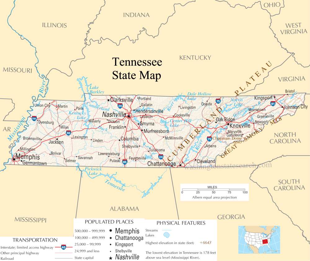
from the National Atlas of the United States
United States Department of the Interior
Tennessee State Map
Explore Tennessee with an interactive map featuring Street View, satellite and terrain views. Live weather, local news and location details for Tennessee — plus links to detailed street maps for 642 cities and towns across the state.
Map search is available for a limited number of queries per session to manage costs. Be specific — search precisely for best results.
| State | Tennessee (TN) |
| Capital | Nashville |
| Largest City | Nashville |
| Country | United States |
| Latitude | 35.747845 |
| Longitude | -86.692345 |
| Population | 6,910,840 |
| Cities & Towns | 642 |
Tennessee stretches across a varied topography that functions as a slow transition from the rugged spine of the Appalachian chain to the wide, sediment-heavy plains of the Mississippi River. In the east, the landscape fractures into high, forested ridgelines where the air retains a sharp, pine-scented dampness even at midday. These mountains give way to the central basin, a limestone depression that mimics the shape of a shallow bowl, before the land flattens entirely toward the western border. The Tennessee River performs a deliberate, looping journey through these distinct provinces, acting as both a physical divider and a connective artery that dictates the flow of the state’s internal geography. When the evening light catches the dark, silt-heavy surface of the river, the water takes on a bruised, metallic sheen that seems to hold the weight of the land itself.
Indigenous nations—the Cherokee, the Chickasaw, and the Shawnee—long occupied these river valleys and mountain passes, organizing their lives around the seasonal migrations of game and the predictable flooding of the soil. European arrival brought a violent collision of interests, as traders and settlers pushed through the Cumberland Gap, transforming frontier outposts into permanent, fortified settlements. Tennessee achieved statehood as the sixteenth member of the Union, defined early on by a frontier spirit that was as much about isolation as it was about expansion. The subsequent decades saw the state pulled apart by the internal anxieties of the Civil War, leaving behind a landscape where the ghosts of industrial ambition and agrarian loss still linger in the architecture of town squares and the quiet decay of old farmsteads.
Agriculture and industry have long vied for dominance here, reflecting the state’s shift from subsistence farming to large-scale production. Historically, the western lowlands relied on the deep, black earth to produce vast quantities of cotton, a crop that dictated the social and economic rhythms of the region for generations. Today, the focus has broadened to include a significant automotive manufacturing sector and a robust chemical industry, though the state remains deeply tethered to its land-based roots. In the middle regions, the tradition of cattle grazing and tobacco cultivation persists, maintaining a connection to the soil that feels intentional rather than vestigial. Even in the bustle of modern factories, the work is often punctuated by the sight of hawks circling over nearby fields of winter wheat, reminding the labor force that the land continues to operate on its own ancient, indifferent schedule.
Cultural expression in Tennessee is defined by a persistent, vocal quality that finds its highest articulation in music and literature. From the bluegrass echoes of the eastern highlands to the electric, soul-inflected blues that emerged from the urban centers of the west, the sound of the state is a jagged, honest reflection of its people. This creative output is mirrored in a deep-seated devotion to collegiate sports, where the intensity of a Saturday afternoon in a stadium can feel like a secular religion, unifying disparate communities under a single banner of color and loyalty. Food remains a point of pride, characterized by the slow, patient application of smoke to meat and a reliance on local, seasonal staples that have been prepared the same way for a century. The pace of life here is not necessarily slow, but it is deliberate, marked by a tendency to linger in conversation long after the business at hand has been concluded, as if everyone is waiting for the humidity to break so the world can finally be seen clearly.
Tennessee City and Town Maps
A
B
C
D
E
F
G
H
J
K
L
M
N
O
P
R
S
T
U
V
W
Tennessee Maps — Interactive Map, Street View, Weather & News
This page provides an interactive Google map of Tennessee (TN) with Street View, satellite and terrain views, alongside links to detailed street maps for 642 cities and towns across the state. The state capital is Nashville and the largest city is Nashville, with a state population of approximately 6,910,840.
Each city and town map page includes an embedded street and satellite map. Live weather where available combines National Weather Service forecasts with Open-Meteo graphical data including hourly and 7-day outlooks. Local and world news, Wikipedia location summaries, and precise GPS coordinates are included where available.
Location data is sourced from the USGS GNIS database and verified by coordinates, not name matching alone.
