A large detailed map of Vermont State
This is a large, detailed map of Vermont. There are links to many Vermont localities below. Our website format reduces the display size for uniformity. Here is a link to the full-size image that is more easily readable.
View our Vermont State county map
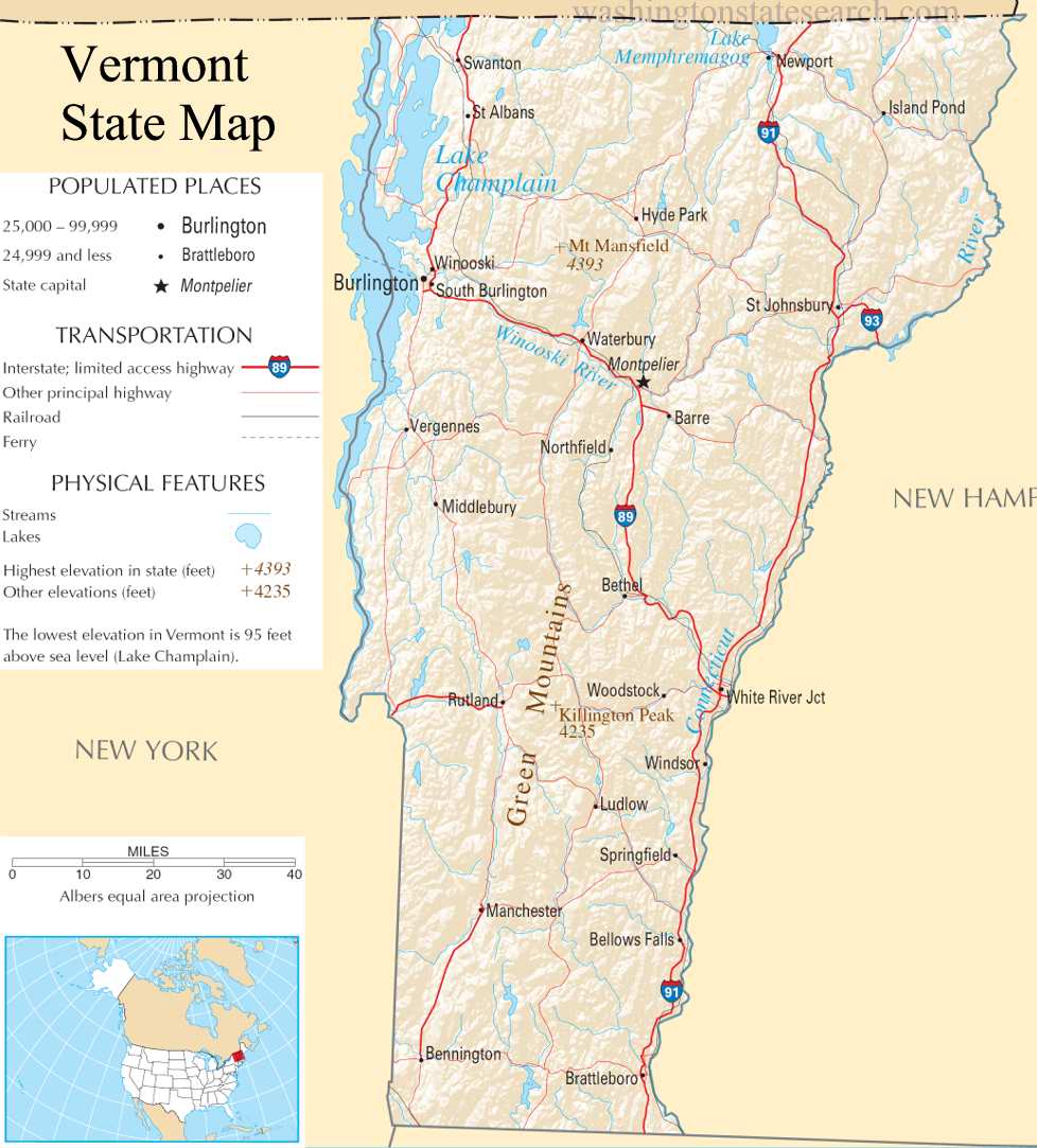
from the National Atlas of the United States
United States Department of the Interior
Vermont State Map
Explore Vermont with an interactive map featuring Street View, satellite and terrain views. Live weather, local news and location details for Vermont — plus links to detailed street maps for 181 cities and towns across the state.
Map search is available for a limited number of queries per session to manage costs. Be specific — search precisely for best results.
| State | Vermont (VT) |
| Capital | Montpelier |
| Largest City | Burlington |
| Country | United States |
| Latitude | 44.045876 |
| Longitude | -72.710686 |
| Population | 643,077 |
| Cities & Towns | 181 |
Vermont asserts itself through the rugged, north-south axis of the Green Mountains, a range that acts as the state’s geological backbone and dictates the flow of every watershed. To the west, the immense, slate-colored expanse of Lake Champlain serves as a vast inland sea, its shoreline defining the transition from the low-lying basin to the steep, hemlock-shadowed ascents of the interior. The terrain is defined by these sudden verticalities; rivers like the Winooski and the White cut narrow, winding paths through granite and schist, creating isolated valleys where the evening fog often lingers long after the sun has cleared the ridge-lines. In the autumn, the light here turns a brittle, metallic gold, illuminating the dense hardwood forests that cover the slopes until the frost descends, turning the foliage into a muted, bruised palette of rust and charcoal.
Vermont emerged from the ancestral territories of the Abenaki, whose deep knowledge of the river systems and seasonal migrations laid the silent foundation for later colonial movement. The land became a contested frontier during the eighteenth century, caught between the competing land grants of New York and New Hampshire, a friction that birthed a fierce, independent militia known for resisting external authority. This spirit of autonomy persisted through the transition to statehood, as settlers cleared the rocky soil to establish self-sufficient townships centered around the meeting house and the mill. The historical weight of this era remains palpable in the weathered, hand-hewn beams of old barns and the way the cemeteries, filled with slate markers, seem to occupy the most prominent, wind-swept knolls overlooking the valley floors.
Agriculture remains the primary pulse of the state, though it has evolved from the early nineteenth-century craze for Merino sheep into a complex network of intensive dairy farming and artisanal production. The landscape is marked by the geometry of fence lines and the pervasive scent of damp silage and curing hay, a rhythm that dictates the labor of the seasons. Maple-sugaring remains a ritualized industry, a frantic, late-winter race against the thawing ground where sap is drawn from the maples as the nights remain freezing and the days grow deceptively mild. Beyond the farms, the economy reflects a modern shift toward precision manufacturing and the careful stewardship of natural resources, yet the primary output remains a commitment to a scale of production that respects the limits of the terrain, favoring quality over the vast, industrialized yields seen elsewhere.
Cultural life in Vermont is defined by an insistence on a slower, more deliberate pace, where the voice of the community is heard in the town meeting and the local gathering place. Literature and the arts have long been influenced by the starkness of the winters, producing a body of work that favors clarity and the precise observation of the natural world over grand artifice. Athletic endeavors are similarly tethered to the landscape, with Nordic and alpine skiing acting as a winter necessity rather than a mere leisure pursuit. Even in the height of mid-summer, when the air is thick with the sound of crickets and the heat radiates off the dark pavement of a covered bridge, there is an underlying awareness of the cold to come, a shared understanding that living here requires a constant, quiet negotiation with the elements.
Vermont City and Town Maps
B
C
D
E
F
G
H
J
L
M
N
P
S
W
Vermont Maps — Interactive Map, Street View, Weather & News
This page provides an interactive Google map of Vermont (VT) with Street View, satellite and terrain views, alongside links to detailed street maps for 181 cities and towns across the state. The state capital is Montpelier and the largest city is Burlington, with a state population of approximately 643,077.
Each city and town map page includes an embedded street and satellite map. Live weather where available combines National Weather Service forecasts with Open-Meteo graphical data including hourly and 7-day outlooks. Local and world news, Wikipedia location summaries, and precise GPS coordinates are included where available.
Location data is sourced from the USGS GNIS database and verified by coordinates, not name matching alone.
