Ross Lake National Recreation Area
Washington State
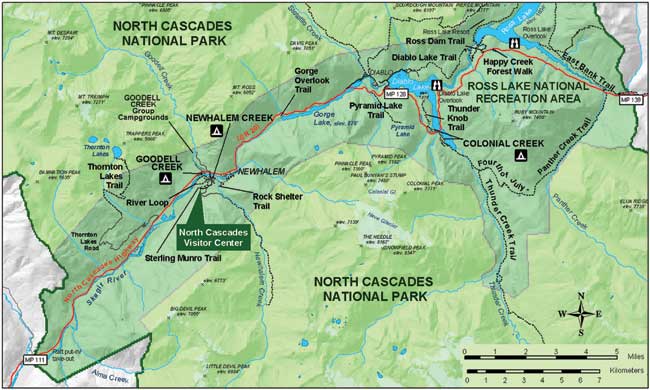
Home Page > Washington State Maps > Washington State National Parks > Ross Lake National Recreation Area Map
Ross Lake National Recreation Area - Washington State
from the National Park Service

Diablo Lake (above left), Pinnacle Peak (above right) and Pyramid Peak (bottom right)
are all visible from Ross Lake National Recreation Area / NPS photos
Ross Lake National Recreation Area
Accessed along State Route 20, this thirty mile upper area of the Skagit River watershed offers many of the region's best camping, hiking and boating opportunities. The map above and the trail chart below will help you plan your adventure. A series of overlooks and accessible trails are available to those seeking a retreat along Washington state's first designated scenic highway.
The free flowing section of the Skagit River below Newhalem provides excellent rafting and wildlife observation opportunities. Careful planning is necessary to float the swift Skagit River; a launch is located adjacent to Goodell Creek Campground.
Diablo Lake offers easy accessibility for water activities. Thunder Creek, its major tributary, carries fine glacial sediment that gives the lake its brilliant turquoise color. This valley is surrounded by the highest concentration of glaciers in the lower 48 states. Last winter's storm washed away several bridges in the Thunder Creek drainage.
Ross Lake winds nearly 25 miles north from Ross dam to Hozomeen on the Canadian border, creating the largest of the three lakes. A quality sport fishery opens July 1 each year on the lake. For special regulations contact a ranger station.
from the National Park Service