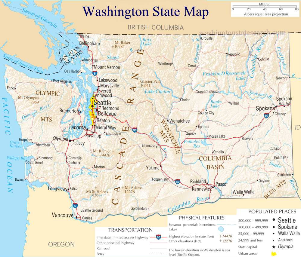
A large detailed map of Washington State
This is a large, detailed map of Washington. There are links to many Washington localities below.
View our Washington State county map
from the National Atlas of the United States
United States Department of the Interior
Washington State Map
Explore Washington with an interactive map featuring Street View, satellite and terrain views. Live weather, local news and location details for Washington — plus links to detailed street maps for 792 cities and towns across the state.
Map search is available for a limited number of queries per session to manage costs. Be specific — search precisely for best results.
| State | Washington (WA) |
| Capital | Olympia |
| Largest City | Seattle |
| Country | United States |
| Latitude | 47.3438 |
| Longitude | -121.3039 |
| Population | 7,705,281 |
| Cities & Towns | 792 |
About Washington
Washington unfolds in a dramatic tapestry of natural wonders, its landscape sculpted by ancient glaciers and the persistent Pacific. To the west, a rugged coastline meets the vast ocean, punctuated by deep inlets and island archipelagos that hum with maritime life. Inland, the Cascade Range dramatically divides the state, its snow-capped peaks casting long shadows over fertile valleys and dense evergreen forests. East of the mountains, the terrain transforms into rolling hills, high desert plateaus, and the vast, productive basins fed by mighty rivers. From the temperate rainforests of the Olympic Peninsula to the arid beauty of the Columbia Basin, Washington offers a breathtaking diversity of environments, a constant reminder of nature's raw power and delicate artistry.
The human story of Washington is one of deep roots and continuous evolution. Indigenous peoples have called this land home for millennia, their connection to the rivers, forests, and coast shaping a rich cultural heritage that persists today. European explorers and settlers arrived later, drawn by the promise of abundant resources and strategic harbors, gradually establishing communities that would eventually form the backbone of the modern state. Washington officially joined the Union in 1889, its growth fueled by waves of migration and innovation, transforming its wild frontier into a dynamic hub of commerce and culture. The spirit of resilience and forward-thinking continues to define the people of Washington.
Washington's economy is as varied as its geography, a powerful engine driven by innovation and natural bounty. Agriculture flourishes in its fertile valleys, producing world-renowned apples, berries, and wine grapes, while the bounty of the Pacific sustains a vital fishing industry. Manufacturing, particularly in aerospace and advanced technology, forms a cornerstone of its economic strength, with global companies calling Washington home. Energy production, leveraging hydroelectric power from its abundant rivers, plays a significant role, alongside a thriving tourism sector that draws visitors to its natural splendor and urban attractions. Major cities like Seattle and Spokane serve as economic and cultural anchors, radiating influence across the state.
The cultural pulse of Washington beats with a unique rhythm, a blend of independent spirit and community engagement. Its identity is shaped by a deep appreciation for the outdoors, evident in the passionate support for its professional sports teams, from the roar of the football stadium to the cheers at a baseball game. Annual festivals celebrate everything from music and art to the state's agricultural heritage, drawing people together in joyous commemoration. The cuisine often reflects the state's natural larder, featuring fresh seafood, local produce, and craft beverages, enjoyed in bustling city cafes and cozy rural eateries. This vibrant mix of tradition and modernity defines the character of life throughout Washington.
Other Maps from Washington State
Mount St. Helens Recreation Map
Washington State Digital Elevation Map (Topographic Map)
Washington State National Parks and Reserves
Washington State National Parks Map
Mount Rainier National Park Map
Olympic National Park Map
Ross Lake National Recreation Area Map
Washington State Geological Maps
Columbia River basin with dams highlighted | Columbia River Flood Basalts map
Major Washington State Volcanoes Map
Mount Rainier Lahar Lava Flow Hazard Map
Potentially Active Volcanoes in the Western United States Map
Washington State and the Columbia River Drainage Map
Washington State Volcanics Map
Washington City and Town Maps
A
B
C
D
E
F
G
H
K
L
M
N
O
P
Q
R
S
T
U
V
W
Y
Z
Washington Maps — Interactive Map, Street View, Weather & News
This page provides an interactive Google map of Washington (WA) with Street View, satellite and terrain views, alongside links to detailed street maps for 792 cities and towns across the state. The state capital is Olympia and the largest city is Seattle, with a state population of approximately 7,705,281.
Each city and town map page includes an embedded street and satellite map. Live weather where available combines National Weather Service forecasts with Open-Meteo graphical data including hourly and 7-day outlooks. Local and world news, Wikipedia location summaries, and precise GPS coordinates are included where available.
Location data is sourced from the USGS GNIS database and verified by coordinates, not name matching alone.