A large detailed map of Washington State Counties
Explore Washington with an interactive map featuring Street View, satellite and terrain views. Browse all 39 counties of Washington below, with links to every city and town map page. Live weather and local news are included on every location page.
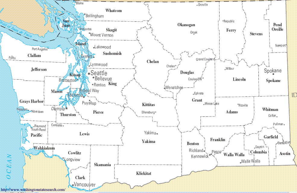
from the National Atlas of the United States
United States Department of the Interior
Washington State Map
Map search is available for a limited number of queries per session to manage costs. Be specific — search precisely for best results.
| State | Washington |
| Capital | Olympia |
| Country | United States of America |
| Counties | 39 |
| Latitude | 47.400902 |
| Longitude | -121.490494 |
| Cities & Towns | 792 |
| State Map | Washington Maps |
About Washington
Washington presents a topography defined by the massive, jagged spine of the Cascade Range, which acts as a climatic border between the maritime west and the continental east. To the west, the land is defined by the labyrinthine inlets of the Puget Sound and the dense, moss-heavy hush of the Olympic rainforest, where the air holds a permanent, heavy moisture that seems to slow the very passage of time. To the east, the terrain breaks into high desert plateaus and deep, basalt-lined river canyons, where the light at dusk turns the dry bunchgrass a startling, bruised violet. The rivers here, fed by glacial melt, carve through the landscape with a relentless, cold urgency, carving the state into distinct ecological theaters that vary from the salt-spray coast to the arid, golden wheat fields of the Palouse.
Indigenous nations have long maintained a profound connection to these lands, managing the seasonal cycles of salmon and cedar long before the arrival of maritime fur traders and the subsequent influx of settlers seeking timber and homesteads. The state’s early development was marked by the difficult, muddy toil of clearing ancient forests and establishing rail lines that linked the deep-water harbors to the hinterlands. Washington achieved statehood in the late nineteenth century, a period during which the frontier began to harden into a structured society, defined by the grit of laborers in the lumber camps and the aspirations of those who navigated the treacherous mountain passes. This history remains visible in the weathering of old brick facades and the enduring resilience of communities that have survived the boom-and-bust cycles of extraction industries.
Economic life in Washington has evolved from a reliance on raw materials—the harvesting of timber, the abundance of salmon, and the tilling of volcanic soil—into a complex architecture of global commerce and technological innovation. The eastern basins remain a powerhouse of agricultural production, where the irrigation of high-desert soil yields endless rows of apples, hops, and grapes, the vines stretching toward the horizon in precise, disciplined lines. Meanwhile, the Puget Sound region has transitioned into a hub for aerospace engineering and digital infrastructure, creating a sharp contrast between the quiet, mechanical hum of factories and the silent, data-driven corridors of modern industry. This shift has not erased the state’s past, but rather layered the high-tech present over the enduring, fiber-rich legacy of the working waterfront and the orchard row.
Cultural identity in Washington is often expressed through a contemplative, slightly reserved sensibility that mirrors the long, gray winters and the inward-looking pace of life in the evergreen shadows. The local voice is often quiet, favoring a dry humor and a preference for the outdoors, whether that means trekking through high alpine meadows or following the progress of professional teams as they play in stadiums that trap the sound of the rain. Literature and music have flourished in this damp, reflective climate, producing art that feels as grounded as the basalt cliffs and as fluid as the Sound’s tidal currents. Even in the bustle of daily life, there is an appreciation for the simple, honest quality of a meal sourced from nearby waters or fields, a small, recurring ritual that keeps the people connected to the specific, cooling temperament of the land.
Washington Cities and Towns by County
Chelan County
Clallam County
Clark County
Cowlitz County
Grant County
Grays Harbor County
Island County
Jefferson County
King County
Kitsap County
Kittitas County
Klickitat County
Okanogan County
Pacific County
Pierce County
San Juan County
Skagit County
Snohomish County
Spokane County
Thurston County
Walla Walla County
Whatcom County
Washington County Maps & Location Information
This page provides an interactive Google map of Washington (WA) with Street View, satellite and terrain views, alongside links to detailed street maps for all 792 cities and towns across the state organised by county. Washington has 39 counties, with the state capital at Olympia.
Every locality page includes an embedded street and satellite map alongside live weather where available — combining National Weather Service forecasts with Open-Meteo graphical data including hourly observations and 7-day outlooks. Local and world news feeds, Wikipedia summaries and editorially written descriptions are included where available.
Location data is sourced from the USGS GNIS database and the SimpleMaps US Cities dataset, verified by coordinates rather than name matching alone.
