A large detailed map of West Virginia State Counties
Explore West Virginia with an interactive map featuring Street View, satellite and terrain views. Browse all 55 counties of West Virginia below, with links to every city and town map page. Live weather and local news are included on every location page.
View our West Virginia State map
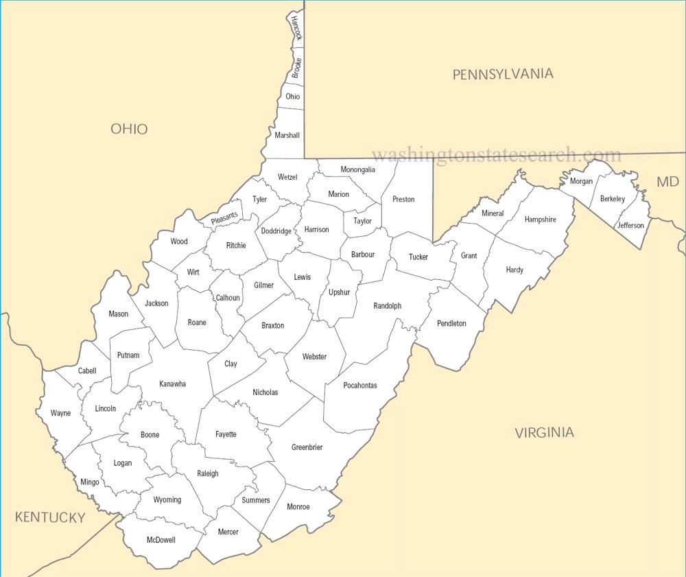
from the National Atlas of the United States
United States Department of the Interior
West Virginia State Map
Map search is available for a limited number of queries per session to manage costs. Be specific — search precisely for best results.
| State | West Virginia |
| Capital | Charleston |
| Country | United States of America |
| Counties | 55 |
| Latitude | 38.491226 |
| Longitude | -80.954453 |
| Cities & Towns | 407 |
| State Map | West Virginia Maps |
About West Virginia
West Virginia exists as a profound geological upheaval, defined by the relentless compression of the Appalachian range where ridge after ridge of hardwood forest rises in jagged, vertical succession. The landscape is a labyrinth of deep hollows and narrow, mist-heavy valleys cut by rivers that carve through ancient limestone and sandstone with an insistent, cold urgency. There is no coastline here, only the constant movement of water—the New River, the Gauley, and the Monongahela—acting as the lifeblood of a terrain that refuses to flatten. At dusk, the light catches the blue-gray haze of the mountains, turning the horizon into a series of bruised, indigo layers that seem to hold the heat of the day long after the sun has vanished behind the hemlocks.
Indigenous nations, including the Monongahela and later the Shawnee, traversed these high passes for generations before European settlers arrived, drawn by the promise of timber and the stubborn isolation of the high country. The state emerged from a violent schism during the nineteenth century, born of a fierce refusal to align with the plantation economies of the lowlands. This independence became a formative, defiant identity, forged in the fires of labor uprisings and the lonely struggle for autonomy against distant interests. History here is not merely a record of events, but a lingering presence, felt in the way the air thins as one climbs toward the high plateaus, carrying the weight of coal-camp memories and the echoes of those who fought for their dignity in the dark of the earth.
Industry has long dictated the rhythm of West Virginia, from the extraction of bituminous coal that powered the industrial expansion of the nation to the cultivation of steep, rocky fields where tobacco and corn once clung to the slopes. For decades, the extraction of subterranean resources meant that the wealth of the land was carried away on rail lines while the communities remained tethered to the fluctuating demands of global markets. Today, the economy shifts toward a fragile, modern reconciliation between the preservation of its natural majesty and the need for sustainable livelihoods. In the early morning, one might watch the fog lift from a reclaimed strip mine, revealing a quiet resilience in the way the grasses begin to reclaim the scarred earth, signaling a slow transition from the soot of the past to a cleaner, yet uncertain, future.
West Virginia possesses a cultural character shaped by the isolation of its geography, resulting in a soundscape dominated by the high, lonesome notes of fiddle music and the percussive clarity of the banjo. This is a place where food remains grounded in the necessity of the seasons—ramps pulled from the damp spring soil, venison smoked over hickory, and the simple, sustaining comfort of a pepperoni roll. The pace of life is dictated by the incline of the road and the necessity of navigating the mountain weather, fostering a quiet, observant citizenry who value the intimacy of their neighborhood gatherings above the noise of the outside world. To live here is to accept that the mountains provide a sanctuary, one where the silence of a heavy winter snowfall creates a stillness so total that it feels as though the world has paused, if only for an hour, to catch its breath.
West Virginia Cities and Towns by County
Fayette County
Greenbrier County
Harrison County
Kanawha County
Logan County
Marion County
Mingo County
Monongalia County
Preston County
Raleigh County
Randolph County
Wood County
West Virginia County Maps & Location Information
This page provides an interactive Google map of West Virginia (WV) with Street View, satellite and terrain views, alongside links to detailed street maps for all 407 cities and towns across the state organised by county. West Virginia has 55 counties, with the state capital at Charleston.
Every locality page includes an embedded street and satellite map alongside live weather where available — combining National Weather Service forecasts with Open-Meteo graphical data including hourly observations and 7-day outlooks. Local and world news feeds, Wikipedia summaries and editorially written descriptions are included where available.
Location data is sourced from the USGS GNIS database and the SimpleMaps US Cities dataset, verified by coordinates rather than name matching alone.
