A large detailed map of Colorado State Counties
Explore Colorado with an interactive map featuring Street View, satellite and terrain views. Browse all 64 counties of Colorado below, with links to every city and town map page. Live weather and local news are included on every location page.
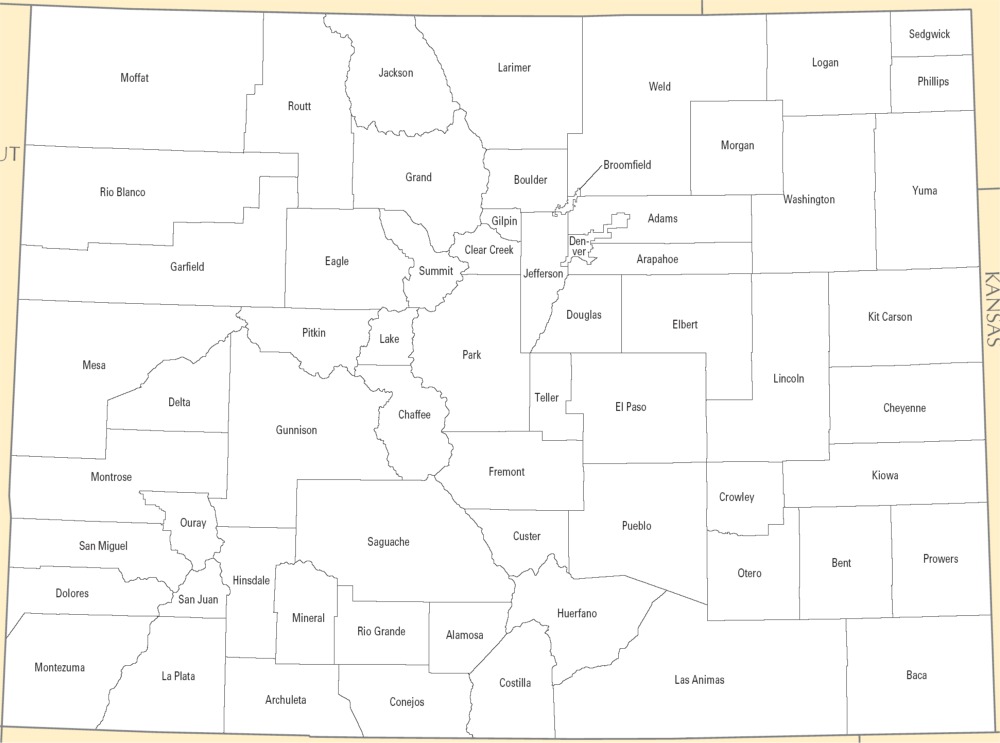
from the National Atlas of the United States
United States Department of the Interior
Colorado State Map
Map search is available for a limited number of queries per session to manage costs. Be specific — search precisely for best results.
| State | Colorado |
| Capital | Denver |
| Country | United States of America |
| Counties | 64 |
| Latitude | 39.059811 |
| Longitude | -105.311104 |
| Cities & Towns | 468 |
| State Map | Colorado Maps |
About Colorado
Colorado rises from the flat, parched expanse of the high plains, a sudden tectonic defiance that forces the horizon upward into the jagged, granite ramparts of the Front Range. This landscape is defined by its verticality, where the air thins to a sharp, electric clarity that makes distant summits appear close enough to touch. Great rivers like the Colorado and the Arkansas begin as glacial melt, carving deep, narrow canyons through the belly of the state before spilling out toward the arid basins. The climate is a study in extremes, defined by a dry, continental intensity that preserves the scent of pine and sage long after the sun has dipped behind the Continental Divide. Even in the height of summer, a stubborn, gleaming white patch of snow often clings to the shaded crevices of the high peaks, a cooling reminder of the altitude that governs everything that grows here.
Colorado carries the heavy, layered memory of the Ute, Arapaho, and Cheyenne nations, whose movements across the plains and mountain passes predated the chaotic, violent arrival of European prospectors. The mid-nineteenth century brought a frantic, gold-seeking desperation, transforming quiet valleys into scarred earth and bustling, wooden-slat camps overnight. Statehood arrived as a formal recognition of this rapid, often brutal expansion, binding the territory to a federal identity while the region still operated under its own rugged, improvised laws. These formative years left behind skeletal mining infrastructure—weathered timber frames and iron ore chutes—that now stand as relics against the stark blue sky. The history of the region is not merely a chronicle of mining, but a long, difficult negotiation between the harsh limitations of the land and the unrelenting ambition of those who arrived to claim it.
Economic life in Colorado has migrated from the extraction of silver and coal toward a diverse machinery of technology, aerospace, and sustainable energy, yet the soil remains a central character in the narrative. Agriculture persists in the form of sprawling orchards and fields of irrigated grain, utilizing the seasonal cycles of water that define the rhythm of rural life. Where miners once dug into the earth for quick fortune, modern industry now looks to the sky, utilizing the state’s high-altitude advantages for satellite telemetry and research. This shift has not erased the past; instead, it has repurposed the grit of earlier generations into a sophisticated, highly educated workforce. The labor here is characterized by a strange, persistent independence, where the legacy of the solitary prospector is felt in the way businesses operate, favoring self-reliance and the quiet, steady pursuit of innovation over centralized corporate conformity.
Cultural life in Colorado moves at a pace dictated by the light, which turns a bruised, liquid gold as it filters through the aspen groves in September. The people here exhibit a pragmatic enthusiasm for the outdoors, where professional and collegiate athletics are pursued with an intensity that borders on religious observance. Music and literature in the region often reflect the isolation of the mountains, favoring themes of endurance and the stark beauty of a landscape that does not care if you are watching. Foodways have evolved from simple, hearty fare meant to fuel a day’s labor into a sophisticated blend of high-desert agriculture and global influence, yet the flavor of a locally grown peach or a cut of high-country lamb remains the most honest expression of the land. In the evening, when the temperature drops sharply and the shadows stretch long across the sagebrush, there is a profound silence that settles over the valleys, a reminder that the wild is never more than a few miles away from the quietest neighborhood.
Colorado Cities and Towns by County
Adams County
Arapahoe County
Boulder County
Chaffee County
Douglas County
Fremont County
Garfield County
Jefferson County
Larimer County
Mesa County
Morgan County
Pueblo County
Weld County
Colorado County Maps & Location Information
This page provides an interactive Google map of Colorado (CO) with Street View, satellite and terrain views, alongside links to detailed street maps for all 468 cities and towns across the state organised by county. Colorado has 64 counties, with the state capital at Denver.
Every locality page includes an embedded street and satellite map alongside live weather where available — combining National Weather Service forecasts with Open-Meteo graphical data including hourly observations and 7-day outlooks. Local and world news feeds, Wikipedia summaries and editorially written descriptions are included where available.
Location data is sourced from the USGS GNIS database and the SimpleMaps US Cities dataset, verified by coordinates rather than name matching alone.
