A large detailed map of Iowa State
This is a large, detailed map of Iowa. There are links to many Iowa localities below. Our website format reduces the display size for uniformity. Here is a link to the full-size image that is more easily readable.
View our Iowa State county map
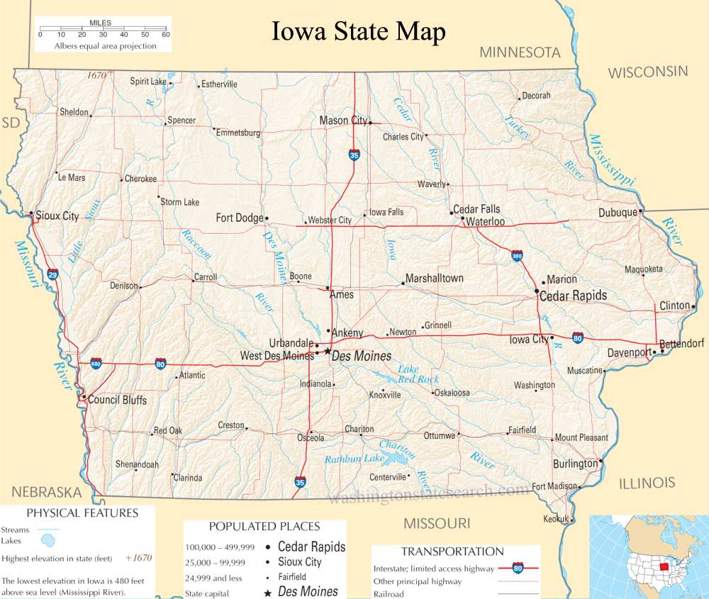
from the National Atlas of the United States
United States Department of the Interior
Iowa State Map
Explore Iowa with an interactive map featuring Street View, satellite and terrain views. Live weather, local news and location details for Iowa — plus links to detailed street maps for 1,007 cities and towns across the state.
Map search is available for a limited number of queries per session to manage costs. Be specific — search precisely for best results.
| State | Iowa (IA) |
| Capital | Des Moines |
| Largest City | Des Moines |
| Country | United States |
| Latitude | 42.011539 |
| Longitude | -93.210526 |
| Population | 3,190,369 |
| Cities & Towns | 1,007 |
Iowa occupies a vast, tilting plane of the American interior, defined by a horizon that seems to pull the sky down toward the earth in a wide, unbroken arc. To the east and west, the state is framed by two great arteries of continental drainage, the Mississippi and the Missouri, which act as bookends to a landscape primarily composed of deep, black glacial till. Between these rivers, the land is a rhythmic succession of swells and depressions, interrupted by the sudden, wind-blown ridges of the Loess Hills that rise like solid waves along the western border. In the late summer, the air holds a singular, heavy clarity, and the light at dusk turns the fields into a sea of muted bronze, revealing a topography that is less a flat plain and more a subtle, working engine of soil and water.
Indigenous nations, including the Ioway, Sauk, and Meskwaki, navigated these river corridors for centuries before the arrival of European fur traders and the subsequent push of westward expansion. Following the acquisition of the territory through the Louisiana Purchase, the arrival of settlers from the eastern states and the later influx of German and Scandinavian immigrants transformed the tallgrass prairie into a grid of townships and section lines. Statehood arrived in the mid-nineteenth century, a period marked by the slow, deliberate work of breaking the heavy sod and establishing the fundamental civic structures that still define the state today. This history is not merely a record of territorial acquisition but a layered account of how distinct ethnic traditions merged into a practical, agrarian identity, leaving behind the enduring architecture of red-brick courthouses and white-steepled churches.
Agriculture remains the primary pulse of the Iowa economy, a disciplined cycle of planting and harvest that dictates the pace of life for much of the population. The state serves as a massive, industrial-scale producer of corn and soybeans, though this output is increasingly complemented by advanced manufacturing, insurance, and wind energy sectors that harness the persistent breezes sweeping across the plains. This production has always required a specific kind of stoicism; the work is seasonal, demanding, and deeply connected to the unpredictable whims of weather and global commodity markets. Even in the modern era, the state maintains a grounded industrial sensibility, where the economy is measured not just in figures but in the visible reality of grain elevators standing like sentinels above the tree line and the steady hum of machinery moving through the fields.
Cultural life in Iowa is characterized by an unshowy, literate civility that often catches the outsider by surprise. Intellectual rigor finds a home in the university towns, where the tradition of the writers' workshop fosters a quiet, intense focus on the craft of language, mirroring the same patience required to manage a farm. On autumn Saturdays, the atmosphere shifts toward the fervent loyalty of collegiate sports, which serve as a common language for a populace otherwise spread across rural expanses. The local culinary landscape relies on the honest, hearty fare of the region—sweet corn, fresh pork, and simple, well-prepared staples—served in spaces that favor function over flourish. There is a particular stillness here, a quality of quietude that allows for a thoughtful, deliberate way of living, where the rhythm of the day is marked by the shifting shadows on the fields and the reliable, steady habits of a community that values substance over spectacle.
Iowa City and Town Maps
A
B
C
D
E
F
G
H
I
J
K
L
M
N
O
P
Q
R
S
T
U
V
W
Iowa Maps — Interactive Map, Street View, Weather & News
This page provides an interactive Google map of Iowa (IA) with Street View, satellite and terrain views, alongside links to detailed street maps for 1,007 cities and towns across the state. The state capital is Des Moines and the largest city is Des Moines, with a state population of approximately 3,190,369.
Each city and town map page includes an embedded street and satellite map. Live weather where available combines National Weather Service forecasts with Open-Meteo graphical data including hourly and 7-day outlooks. Local and world news, Wikipedia location summaries, and precise GPS coordinates are included where available.
Location data is sourced from the USGS GNIS database and verified by coordinates, not name matching alone.
