A large detailed map of Massachusetts State
This is a large, detailed map of Massachusetts. There are links to many Massachusetts localities below. Our website format reduces the display size for uniformity. Here is a link to the full-size image that is more easily readable.
View our Massachusetts State county map
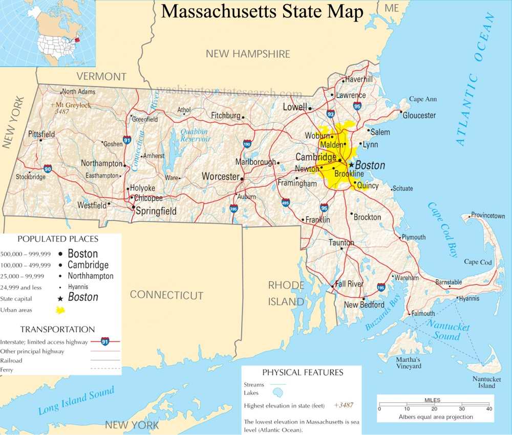
from the National Atlas of the United States
United States Department of the Interior
Massachusetts State Map
Explore Massachusetts with an interactive map featuring Street View, satellite and terrain views. Live weather, local news and location details for Massachusetts — plus links to detailed street maps for 464 cities and towns across the state.
Map search is available for a limited number of queries per session to manage costs. Be specific — search precisely for best results.
| State | Massachusetts (MA) |
| Capital | Boston |
| Largest City | Boston |
| Country | United States |
| Latitude | 42.230171 |
| Longitude | -71.530106 |
| Population | 7,029,917 |
| Cities & Towns | 464 |
Massachusetts occupies a landscape defined by a profound geological contrast, shifting from the serrated granite headlands of the Atlantic coast to the quiet, ancient interior of the western highlands. To the east, the shoreline is a complex geography of salt marshes and glacial kettle ponds, where the air often holds a briny dampness that clings to the wool of a sweater long after the sun has dipped below the horizon. Moving westward, the terrain rises into the folded ridges of the Berkshires, a range of weathered peaks that seem to absorb the gray, heavy light of late autumn afternoons. Between these extremes, the Connecticut River bisects the state, carving a fertile valley that serves as a verdant spine for a region otherwise characterized by glacial debris, rocky soil, and the persistent, stubborn endurance of the New England forest.
Indigenous nations have maintained a presence upon this earth for millennia, managing the coastal estuaries and inland hardwoods long before the arrival of European vessels. The subsequent colonial encounter transformed the region into a laboratory for early American governance and religious fervor, as settlers sought to impose a rigid, orderly structure upon the wilder edges of the continent. Massachusetts emerged from these formative decades as a crucible of revolutionary thought, where the friction between individual conscience and institutional authority ignited a series of events that would eventually redefine the trajectory of the young nation. This history remains visible in the architecture of town centers, where the white steeples and brick meetinghouses stand as quiet, austere witnesses to a past that never truly recedes, but rather informs the present with a sense of deliberate, historical weight.
Industry in the state has evolved from the early reliance on the maritime bounty of the Atlantic—the cod, the whale, and the merchant trade—into a sophisticated economy driven by intellectual labor and technological innovation. The textile mills that once harnessed the power of fast-moving rivers have largely been repurposed, yet the legacy of that manufacturing era remains in the sturdy red-brick facades that dominate many riverfront districts. Agriculture persists in the form of cranberry bogs that flush a deep, bruised crimson against the autumn landscape, and in the small-scale farms that provide a seasonal rhythm to the local diet. Today, the state functions as a global center for medicine and higher education, drawing a constant influx of minds that work to translate theoretical research into the realities of modern life, maintaining a standard of productivity that feels both restless and exacting.
Cultural life in Massachusetts is defined by a distinct, literate severity and a quiet intensity that permeates everything from the crowded, vocal fervor of professional sports arenas to the hushed corridors of its historic libraries. The voice of the region is often clipped and pragmatic, favoring brevity over flourish, a trait that reflects a culture comfortable with the gray, introspective moods of a long winter. Foodways are grounded in the straightforward preparation of the coast, where the preparation of a clam chowder or a lobster roll is treated with the seriousness of a secular ritual. Literature has long been a primary export, with generations of writers finding inspiration in the interplay between the harshness of the climate and the internal lives of its residents. It is a place where the pace of life feels measured, governed by a collective understanding that the land demands a certain level of discipline, and that the beauty of the state is best appreciated in the sharp, clear light of a morning after a storm.
Massachusetts City and Town Maps
A
B
C
D
E
F
G
H
L
M
N
O
P
R
S
T
W
Massachusetts Maps — Interactive Map, Street View, Weather & News
This page provides an interactive Google map of Massachusetts (MA) with Street View, satellite and terrain views, alongside links to detailed street maps for 464 cities and towns across the state. The state capital is Boston and the largest city is Boston, with a state population of approximately 7,029,917.
Each city and town map page includes an embedded street and satellite map. Live weather where available combines National Weather Service forecasts with Open-Meteo graphical data including hourly and 7-day outlooks. Local and world news, Wikipedia location summaries, and precise GPS coordinates are included where available.
Location data is sourced from the USGS GNIS database and verified by coordinates, not name matching alone.
