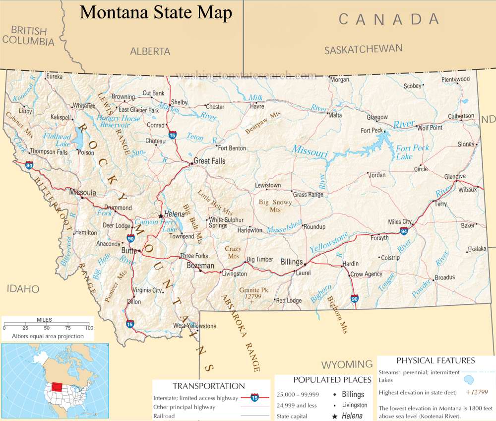
A large detailed map of Montana State
This is a large, detailed map of Montana. There are links to many Montana localities below.
View our Montana State county map
from the National Atlas of the United States
United States Department of the Interior
Montana State Map
Explore Montana with an interactive map featuring Street View, satellite and terrain views. Live weather, local news and location details for Montana — plus links to detailed street maps for 488 cities and towns across the state.
Map search is available for a limited number of queries per session to manage costs. Be specific — search precisely for best results.
| State | Montana (MT) |
| Capital | Helena |
| Largest City | Billings |
| Country | United States |
| Latitude | 47.1492 |
| Longitude | -110.9018 |
| Population | 1,084,225 |
| Cities & Towns | 488 |
About Montana
Montana's vast expanse unfolds with a dramatic grandeur, a land sculpted by ancient forces. Immense prairies, painted in hues of gold and sage, stretch towards horizons that seem to hold the very breath of the sky, giving way to the formidable, snow-capped peaks of the Rocky Mountains. Major arteries like the Missouri and Yellowstone rivers carve their winding paths through this diverse terrain, feeding fertile valleys and nourishing ecosystems that teem with life. This inland reach, far from any ocean coastline, experiences a climate of stark contrasts, from the searing heat of summer to the profound stillness of winter, a testament to its wild and untamed spirit. National treasures like Glacier and Yellowstone National Parks protect some of the most breathtaking landscapes, offering glimpses into a primordial beauty that defines Montana.
The story of Montana is etched in the very earth, a testament to the enduring presence of Native American tribes who lived in harmony with its rhythms for millennia. European settlers, drawn by dreams of opportunity and the allure of the frontier, eventually established a foothold, their endeavors shaping the region's trajectory. Achieving statehood marked a significant chapter, transforming Montana from a wild territory into a recognized entity within the United States. Over time, the ebb and flow of migration, industry, and community building have woven a complex tapestry, shaping the unique character and contemporary identity of Montana as it stands today.
The economy of Montana is deeply rooted in its natural bounty, with agriculture forming a cornerstone of its prosperity, supporting vast ranches and fertile farmlands. Beneath its surface lie significant energy resources, contributing to its industrial landscape, while a growing technology sector and a vibrant tourism industry draw visitors from across the globe. Major cities and regional centers, though spread across this expansive territory, serve as hubs for commerce and culture, connecting communities and facilitating the flow of goods and ideas. Manufacturing also plays a role, adding to the diverse economic fabric of Montana, creating a blend of traditional and modern enterprises.
The cultural identity of Montana is intrinsically linked to its open spaces and the independent spirit of its people, a character often reflected in its annual events and the rhythms of daily life. While professional sports teams might be found in neighboring states, the passion for college athletics runs deep within Montana, fostering a strong sense of community pride. The state's cuisine often celebrates its agricultural heritage, featuring hearty dishes and locally sourced ingredients that speak to the land. From the quiet contemplation inspired by its natural landmarks to the lively gatherings in its towns, the essence of Montana is one of resilience, beauty, and a profound connection to the natural world.
Montana City and Town Maps
A
B
C
D
E
F
G
H
I
J
K
L
M
N
O
P
R
S
T
U
V
W
Z
Montana Maps — Interactive Map, Street View, Weather & News
This page provides an interactive Google map of Montana (MT) with Street View, satellite and terrain views, alongside links to detailed street maps for 488 cities and towns across the state. The state capital is Helena and the largest city is Billings, with a state population of approximately 1,084,225.
Each city and town map page includes an embedded street and satellite map. Live weather where available combines National Weather Service forecasts with Open-Meteo graphical data including hourly and 7-day outlooks. Local and world news, Wikipedia location summaries, and precise GPS coordinates are included where available.
Location data is sourced from the USGS GNIS database and verified by coordinates, not name matching alone.