A large detailed map of Rhode Island State Counties
Explore Rhode Island with an interactive map featuring Street View, satellite and terrain views. Browse all 5 counties of Rhode Island below, with links to every city and town map page. Live weather and local news are included on every location page.
View our Rhode Island State map
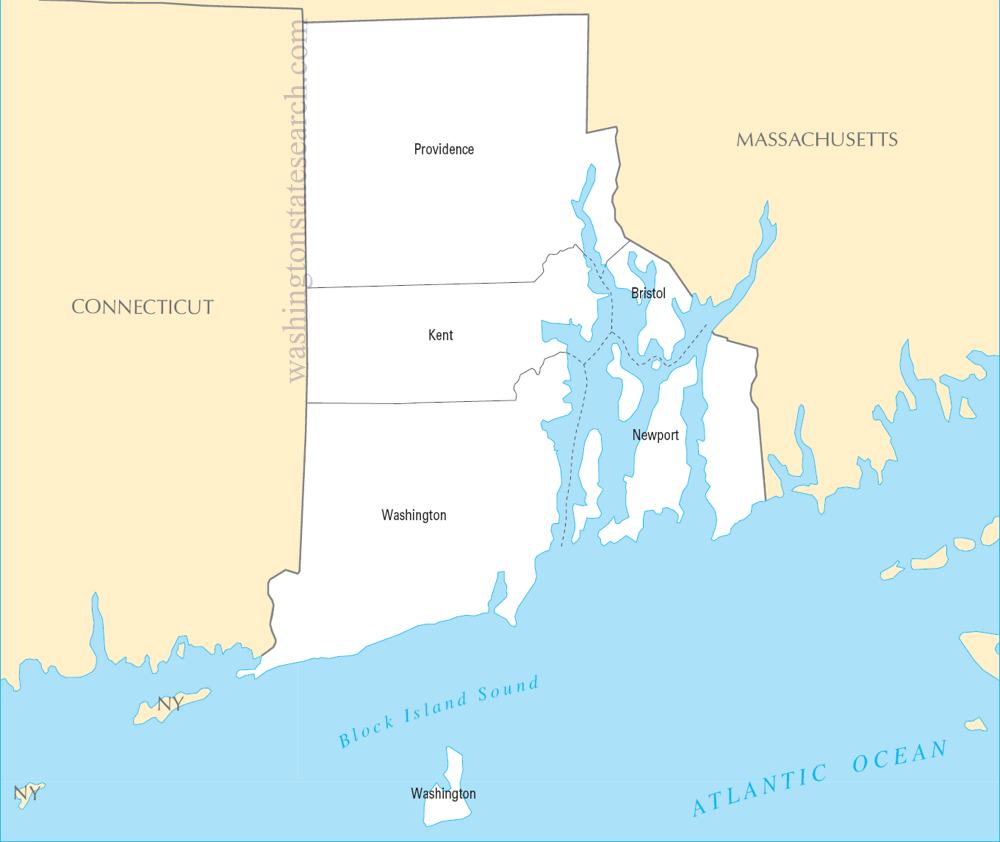
from the National Atlas of the United States
United States Department of the Interior
Rhode Island State Map
Map search is available for a limited number of queries per session to manage costs. Be specific — search precisely for best results.
| State | Rhode Island |
| Capital | Providence |
| Country | United States of America |
| Counties | 5 |
| Latitude | 41.680893 |
| Longitude | -71.51178 |
| Cities & Towns | 34 |
| State Map | Rhode Island Maps |
About Rhode Island
Rhode Island occupies a fractured, intricate geography where the sea does not merely border the land but actively infiltrates it. Narragansett Bay serves as the state’s central artery, a sprawling, brackish lung that pushes deep into the interior, turning the shoreline into a complex jigsaw of peninsulas and islands. The terrain is largely defined by this glacial legacy; the ground is often rocky and thin, yielding to low, granite-ribbed ridges that rise gently from the coastal plain. In the western reaches, the landscape shifts into a dense, hushed interior of forests and freshwater ponds, a stark contrast to the salt-stung marshes that define the southern coast. At dusk, the light over the water takes on a bruised, metallic quality, reflecting off the bay in long, shimmering slivers that seem to hold the day in suspense long after the sun has slipped behind the western hills.
Rhode Island emerged from a radical departure from the rigid orthodoxy of its neighbors, founded on the principle of individual conscience. Indigenous nations, primarily the Narragansett, maintained deep, reciprocal ties to the tidal estuaries and river valleys long before the arrival of European settlers who sought a refuge for divergent religious thought. This commitment to dissent and autonomy became a formative current, shaping a political identity that was often at odds with the surrounding colonies. The state’s early years were marked by a precarious dance with maritime trade and a stubborn insistence on local governance, which eventually propelled it into the forefront of the revolutionary movement. There is a specific gravity to the old colonial squares, where the architecture of the eighteenth century remains, not as a museum exhibit, but as a silent, wood-shingled witness to the state’s early, defiant experimentation with liberty.
Industrial ambition once coursed through the Blackstone River Valley, where the rhythmic clatter of water-powered mills signaled the birth of the American factory system. Rhode Island became a powerhouse of textile manufacturing and precision toolmaking, drawing waves of immigrants who brought their own languages and traditions to the factory floor. While the roar of the looms has faded, the state’s economic pulse remains tied to the sea, shifting from the heavy industry of the past to defense manufacturing, oceanographic research, and a resilient, if seasonal, maritime service sector. The working harbors remain defined by the sharp, brine-heavy scent of bait and diesel, a testament to a long-standing fishing culture that persists despite the encroachment of modern development. This synthesis of historical grit and contemporary innovation creates a distinct economic texture, where the pride of craftsmanship is still measured by the calloused hands that maintain the state’s fleet of vessels.
Rhode Island maintains a cultural character that is as dense and idiosyncratic as its winding backroads. The local palate is defined by peculiar, beloved staples—coffee milk, fried seafood, and distinct, savory dough—that serve as communal touchstones for residents across the state. In the collegiate halls and neighborhood taverns, the conversational tempo is rapid and clipped, a shorthand developed by generations living in such close, overlapping proximity. Sports here are followed with a quiet, intense devotion, often focused on the regional collegiate rivalries that stir genuine passion in the autumn chill. As the fog rolls in off the Atlantic, thickening the air and muffling the sound of the city, there is a tangible sense of isolation that feels protective rather than lonely. It is a place that demands to be known on its own terms, offering a singular, concentrated experience of life that is neither large nor expansive, but deeply, stubbornly present.
Rhode Island Cities and Towns by County
Providence County
Washington County
Rhode Island County Maps & Location Information
This page provides an interactive Google map of Rhode Island (RI) with Street View, satellite and terrain views, alongside links to detailed street maps for all 34 cities and towns across the state organised by county. Rhode Island has 5 counties, with the state capital at Providence.
Every locality page includes an embedded street and satellite map alongside live weather where available — combining National Weather Service forecasts with Open-Meteo graphical data including hourly observations and 7-day outlooks. Local and world news feeds, Wikipedia summaries and editorially written descriptions are included where available.
Location data is sourced from the USGS GNIS database and the SimpleMaps US Cities dataset, verified by coordinates rather than name matching alone.
