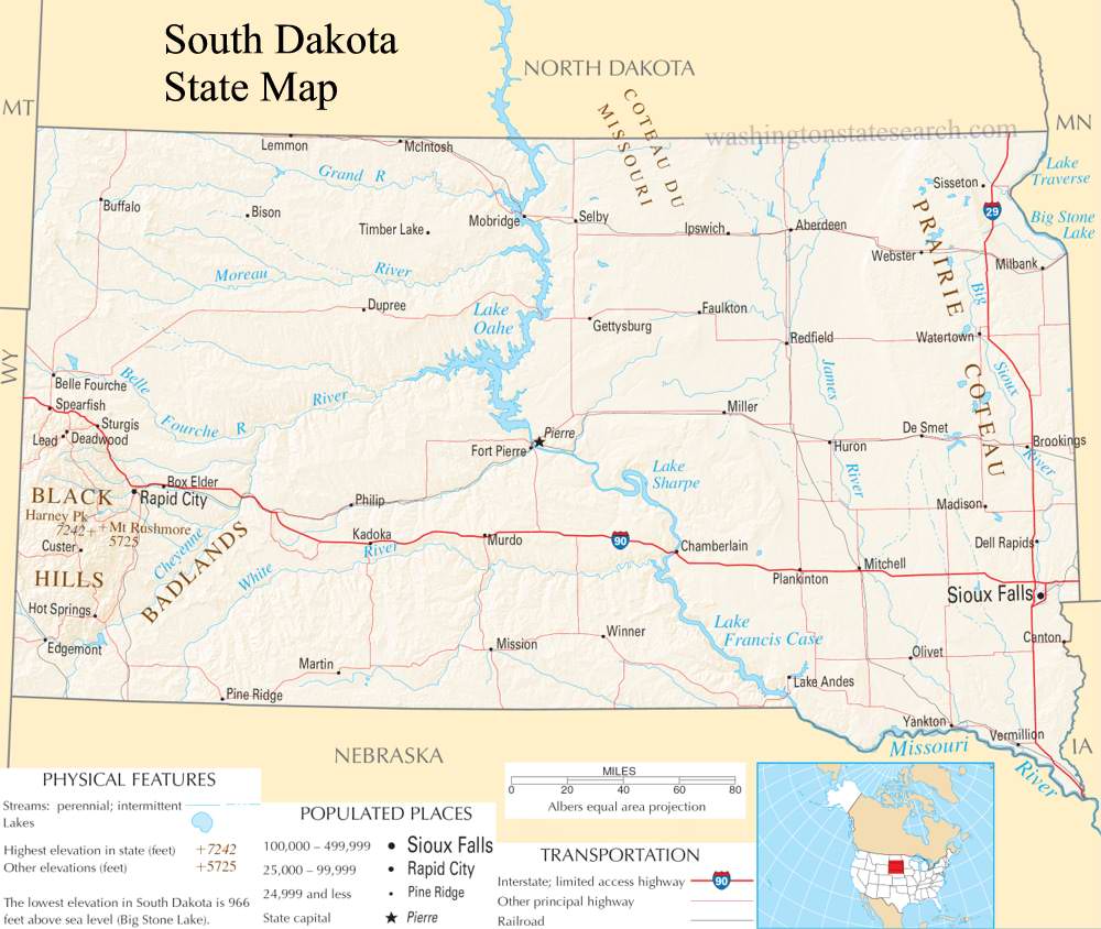
A large detailed map of South Dakota State
This is a large, detailed map of South Dakota. There are links to many South Dakota localities below.
View our South Dakota State county map
from the National Atlas of the United States
United States Department of the Interior
South Dakota State Map
Explore South Dakota with an interactive map featuring Street View, satellite and terrain views. Live weather, local news and location details for South Dakota — plus links to detailed street maps for 480 cities and towns across the state.
Map search is available for a limited number of queries per session to manage costs. Be specific — search precisely for best results.
| State | South Dakota (SD) |
| Capital | Pierre |
| Largest City | Sioux Falls |
| Country | United States |
| Latitude | 44.2818 |
| Longitude | -98.9396 |
| Population | 886,667 |
| Cities & Towns | 480 |
About South Dakota
South Dakota unfolds across a vast expanse, a land of rolling prairies that stretch towards horizons often painted with dramatic skies. Its central heartland is a tapestry of fertile plains, gradually giving way to the rugged beauty of the Black Hills in the west, a dramatic uplift of ancient rock. Major rivers, like the mighty Missouri, trace sinuous paths through the state, shaping the landscape and providing lifeblood to its communities. While South Dakota lacks coastlines, its inland reach is defined by an abundance of natural wonders, from the dramatic badlands formations to the serene waters of its lakes, offering a wild and untamed beauty. The climate here is one of extremes, from hot, humid summers to crisp, cold winters, a rhythm that dictates life across South Dakota.
The deep roots of South Dakota are interwoven with the enduring legacy of its Native American peoples, whose connection to this land stretches back millennia. European explorers and settlers later arrived, drawn by the promise of open spaces and resources, gradually shaping the territory. The journey to statehood was a testament to the resilience and determination of those who called this place home, eventually culminating in its establishment as a distinct entity within the Union. Over generations, the diverse influences of these early inhabitants and subsequent waves of immigrants have coalesced, forging the unique character of contemporary South Dakota. This rich historical narrative is etched into the very fabric of the state, a constant reminder of its formative years and the people who built it.
Agriculture forms the bedrock of South Dakota's economy, with vast fields of corn, soybeans, and wheat defining its rural vistas, alongside robust cattle ranching operations. Beyond the fertile fields, manufacturing and energy production play significant roles, harnessing the state's resources and contributing to its economic vitality. Tourism also draws considerable attention, as visitors are captivated by the natural splendor and iconic landmarks scattered throughout South Dakota. While the state's population is dispersed, regional centers like Sioux Falls and Rapid City serve as important hubs for commerce, services, and innovation, fostering growth and opportunity. This blend of traditional industries and burgeoning sectors ensures a dynamic economic landscape for South Dakota.
The spirit of South Dakota is often found in its wide-open spaces and the resilient character of its people, a quiet strength that echoes the land itself. While professional sports teams are not a major fixture, college athletics, particularly at institutions like South Dakota State University and the University of South Dakota, generate considerable enthusiasm and community pride. Annual events, from county fairs celebrating agricultural bounty to cultural festivals honoring its diverse heritage, punctuate the yearly calendar, offering moments of shared celebration. The cuisine often reflects its agricultural roots, with hearty meals and locally sourced ingredients forming a comforting culinary tradition. Ultimately, the daily life in South Dakota is characterized by a sense of community and a deep appreciation for the natural beauty that surrounds it.
South Dakota City and Town Maps
A
B
C
D
E
F
G
H
J
L
M
N
O
P
Q
R
S
T
U
V
W
South Dakota Maps — Interactive Map, Street View, Weather & News
This page provides an interactive Google map of South Dakota (SD) with Street View, satellite and terrain views, alongside links to detailed street maps for 480 cities and towns across the state. The state capital is Pierre and the largest city is Sioux Falls, with a state population of approximately 886,667.
Each city and town map page includes an embedded street and satellite map. Live weather where available combines National Weather Service forecasts with Open-Meteo graphical data including hourly and 7-day outlooks. Local and world news, Wikipedia location summaries, and precise GPS coordinates are included where available.
Location data is sourced from the USGS GNIS database and verified by coordinates, not name matching alone.