A large detailed map of Virginia State Counties
Explore Virginia with an interactive map featuring Street View, satellite and terrain views. Browse all 123 counties of Virginia below, with links to every city and town map page. Live weather and local news are included on every location page.
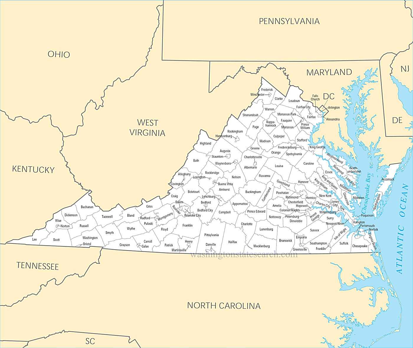
from the National Atlas of the United States
United States Department of the Interior
Virginia State Map
Map search is available for a limited number of queries per session to manage costs. Be specific — search precisely for best results.
| State | Virginia |
| Capital | Richmond |
| Country | United States of America |
| Counties | 123 |
| Latitude | 37.769337 |
| Longitude | -78.169968 |
| Cities & Towns | 805 |
| State Map | Virginia Maps |
About Virginia
Virginia unfolds as a series of geological terraces, beginning where the Atlantic meets the low, marshy fringe of the Tidewater. Here, the land is porous and salt-sprayed, dominated by the wide, sluggish estuaries that drain into the Chesapeake, their waters reflecting a sky that often turns the color of a bruised plum at dusk. Moving westward, the terrain rises into the red-clay Piedmont, a landscape of broad pastures and fractured quartz, before the earth buckles upward into the Blue Ridge. These mountains are not mere walls but ancient, folded spines of rock that shelter the Shenandoah Valley, a limestone basin where the air holds a permanent, crisp clarity and the morning fog clings to the riverbanks like wool left out in the dew.
Indigenous nations—the Powhatan, the Monacan, and others—held this ground long before the first English ships navigated the brackish turns of the James River. Virginia became the crucible of a colonial experiment defined by the uneasy friction between European ambition and the existing order of the landscape. It was a place of early, fragile outposts that eventually hardened into a political center of gravity, producing the architects of the American founding. This history is marked by the heavy, lingering weight of the Civil War, which scarred the soil and left behind a legacy that remains visible in the architecture of the small towns and the quiet, observant silence of the battlefields where the grass grows thick over forgotten iron.
Tobacco defined the early economy, etching a monoculture into the dirt that demanded much from the earth and the people who worked it. While the legacy of that golden leaf persists in the layout of the fields and the rhythm of the harvest, the modern state has pivoted toward a different sort of yield. Northern corridors now pulse with the unseen data of the global internet, operating out of windowless server farms that hum with a cold, electric intensity. Yet, in the southern and western stretches, the economy still relies on the heavy labor of the hand, whether in the quiet pride of the horse-breeding stables or the specialized manufacturing that requires an intimate knowledge of metal and grain.
Life in Virginia moves with a deliberate, sometimes stubborn pace, characterized by a polite reserve that masks a deep, inward-looking intensity. The culture is a layered thing, found in the high-school stadiums on Friday nights where the lights cut through the humid dark, or in the fiddling traditions of the mountain hollows that retain a startling, archaic sharpness. People here favor a style of talk that circles the point before landing, a verbal inheritance that mirrors the winding, narrow roads that follow the contours of the streams. Whether gathering over a platter of smoked meat or observing the collegiate rivalries that divide families every autumn, the residents maintain a connection to the land that feels less like ownership and more like a long, quiet conversation with the geography itself.
Virginia Cities and Towns by County
Accomack County
Albemarle County
Augusta County
Bedford County
Botetourt County
Chesterfield County
Fairfax County
Franklin County
Frederick County
Halifax County
Henrico County
Henry County
Loudoun County
Mecklenburg County
Northampton County
Prince William County
Rockingham County
Shenandoah County
Southampton County
Tazewell County
Wise County
Wythe County
Virginia County Maps & Location Information
This page provides an interactive Google map of Virginia (VA) with Street View, satellite and terrain views, alongside links to detailed street maps for all 805 cities and towns across the state organised by county. Virginia has 123 counties, with the state capital at Richmond.
Every locality page includes an embedded street and satellite map alongside live weather where available — combining National Weather Service forecasts with Open-Meteo graphical data including hourly observations and 7-day outlooks. Local and world news feeds, Wikipedia summaries and editorially written descriptions are included where available.
Location data is sourced from the USGS GNIS database and the SimpleMaps US Cities dataset, verified by coordinates rather than name matching alone.
