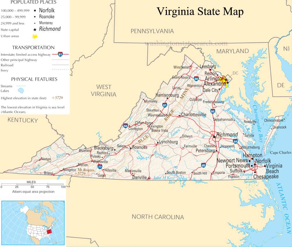
A large detailed map of Virginia State
This is a large, detailed map of Virginia. There are links to many Virginia localities below.
View our Virginia State county map
from the National Atlas of the United States
United States Department of the Interior
Virginia State Map
Explore Virginia with an interactive map featuring Street View, satellite and terrain views. Live weather, local news and location details for Virginia — plus links to detailed street maps for 805 cities and towns across the state.
Map search is available for a limited number of queries per session to manage costs. Be specific — search precisely for best results.
| State | Virginia (VA) |
| Capital | Richmond |
| Largest City | Virginia Beach |
| Country | United States |
| Latitude | 37.7672 |
| Longitude | -78.4892 |
| Population | 8,631,393 |
| Cities & Towns | 805 |
About Virginia
Virginia unfolds a diverse tapestry of landscapes, stretching from the Atlantic coast inland towards the Appalachian Mountains. Its eastern reaches are defined by the Chesapeake Bay, a vast estuary that shapes the Tidewater region with its numerous rivers and harbors, while the Piedmont plateau offers rolling hills and fertile farmlands. Further west, the Blue Ridge Mountains and Shenandoah Valley present dramatic vistas, home to national forests and parks that draw visitors with their natural beauty and outdoor recreation. The climate across Virginia varies, with warmer, humid summers along the coast and cooler temperatures at higher elevations. Major waterways like the James and Potomac rivers have historically served as vital arteries, influencing settlement patterns and the development of communities throughout Virginia.
The story of Virginia is deeply interwoven with the threads of American history, beginning with its rich Native American heritage, whose presence predates European arrival by millennia. European colonization took root early, establishing Virginia as one of the original thirteen colonies and a pivotal center of early American life. It was here that the ideals of a new nation were forged, and its subsequent journey through statehood and pivotal moments in national development shaped its enduring character. The echoes of this past are visible in its historic towns and plantations, a testament to the complex and foundational role Virginia played in the formation of the United States.
Virginia's economy thrives on a dynamic blend of traditional strengths and modern innovation. Agriculture remains a significant sector, with its fertile lands producing a variety of crops and livestock, while the coastal areas support a robust fishing industry. Beyond its agricultural roots, Virginia has emerged as a leader in technology and defense, with major hubs fostering advancements in these fields. Manufacturing, energy production, and a burgeoning service sector also contribute to the state's economic vitality, supported by its strategic location and skilled workforce. Major cities and regional centers across Virginia serve as engines of commerce and culture, reflecting the state's ongoing evolution.
The cultural identity of Virginia is a vibrant mosaic, reflecting its historical depth and contemporary dynamism. From the soulful rhythms of its music to the refined elegance of its historic sites, a distinct character permeates daily life. Major annual events draw crowds from far and wide, celebrating everything from agricultural heritage to artistic expression. The state's cuisine offers a delightful exploration, often featuring fresh seafood from the bay and traditional Southern influences. While professional sports teams in leagues like the NFL and NBA engage passionate fans, the spirit of community and the appreciation for Virginia's unique heritage are perhaps its most enduring hallmarks.
Virginia City and Town Maps
A
B
C
D
E
F
G
H
I
J
K
L
M
N
O
P
Q
R
S
T
U
V
W
Z
Virginia Maps — Interactive Map, Street View, Weather & News
This page provides an interactive Google map of Virginia (VA) with Street View, satellite and terrain views, alongside links to detailed street maps for 805 cities and towns across the state. The state capital is Richmond and the largest city is Virginia Beach, with a state population of approximately 8,631,393.
Each city and town map page includes an embedded street and satellite map. Live weather where available combines National Weather Service forecasts with Open-Meteo graphical data including hourly and 7-day outlooks. Local and world news, Wikipedia location summaries, and precise GPS coordinates are included where available.
Location data is sourced from the USGS GNIS database and verified by coordinates, not name matching alone.