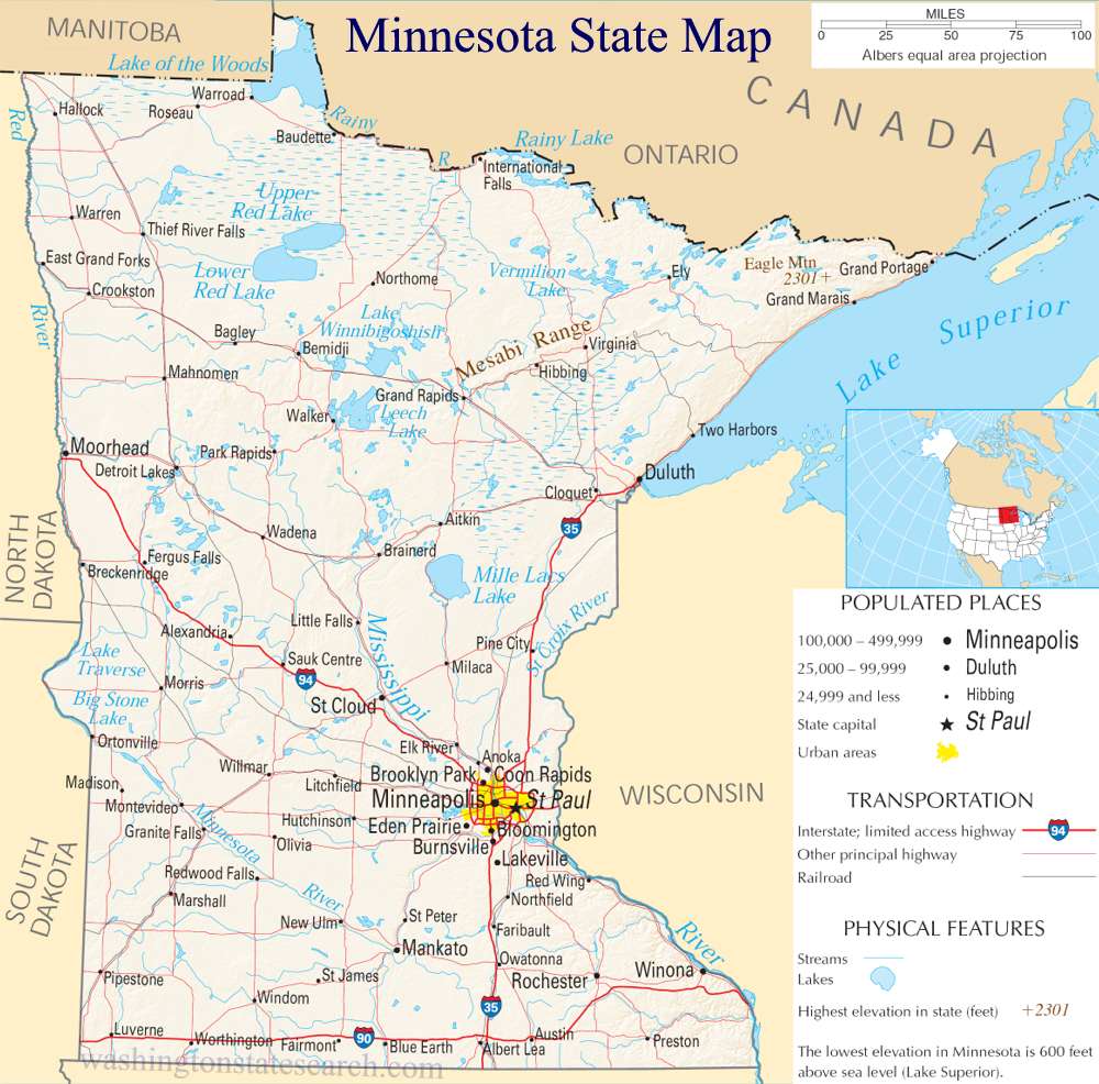
A large detailed map of Minnesota State
This is a large, detailed map of Minnesota. There are links to many Minnesota localities below.
View our Minnesota State county map
from the National Atlas of the United States
United States Department of the Interior
Minnesota State Map
Explore Minnesota with an interactive map featuring Street View, satellite and terrain views. Live weather, local news and location details for Minnesota — plus links to detailed street maps for 911 cities and towns across the state.
Map search is available for a limited number of queries per session to manage costs. Be specific — search precisely for best results.
| State | Minnesota (MN) |
| Capital | Saint Paul |
| Largest City | Minneapolis |
| Country | United States |
| Latitude | 45.4938 |
| Longitude | -94.2541 |
| Population | 5,706,494 |
| Cities & Towns | 911 |
About Minnesota
Minnesota unfolds with a gentle, rolling terrain, a testament to ancient glacial sculpting that has gifted the state an abundance of water. Hundreds of thousands of lakes, from vast expanses like Lake Superior to countless smaller bodies, define its watery heart, earning it the moniker "Land of 10,000 Lakes." This freshwater abundance feeds mighty rivers, including the Mississippi, which begins its journey northward. The landscape transitions from the dense forests of the north, hinting at boreal wilderness, to the fertile prairies of the south, where rich soil supports abundant life. Designated wilderness areas and numerous state parks offer quiet havens for reflection and exploration, showcasing the enduring natural beauty of Minnesota.
The human story of Minnesota is one of deep roots and continuous evolution, shaped by the enduring presence of Indigenous peoples and the waves of European settlers. For millennia, various Native American communities thrived here, developing rich traditions intrinsically linked to the land and its resources. Later, explorers and fur traders navigated its waterways, followed by waves of European immigrants seeking opportunity and a new beginning, drawn by the promise of fertile land and abundant natural wealth. These diverse influences gradually coalesced, forging a unique identity that laid the groundwork for Minnesota's statehood and its modern character. This rich tapestry of heritage continues to inform the vibrant spirit of Minnesota.
Minnesota's economy is a dynamic blend of tradition and innovation, drawing strength from its natural endowments and the ingenuity of its people. Agriculture remains a cornerstone, with vast fields yielding grains, corn, and soybeans, while the dairy and hog industries are substantial contributors. Manufacturing, particularly in areas like food processing and machinery, complements this agricultural base. Emerging sectors like technology and healthcare are increasingly vital, centered in its urban hubs. Tourism flourishes, drawing visitors to its lakes, parks, and cultural attractions, all contributing to the economic vitality of Minnesota.
The cultural landscape of Minnesota is as varied and captivating as its natural geography, fostering a strong sense of community and shared experience. Daily life in Minnesota often embraces the outdoors, with a deep appreciation for all four distinct seasons, each bringing its own beauty and activities. The state boasts passionate fan bases for its professional sports teams across football, basketball, baseball, hockey, and soccer, reflecting a love for competition and camaraderie. Vibrant annual festivals, a burgeoning culinary scene that celebrates local ingredients, and a rich array of arts and cultural institutions further define the lively spirit of Minnesota.
Minnesota City and Town Maps
A
B
C
D
E
F
G
H
I
J
K
L
M
N
O
P
Q
R
S
T
V
W
Z
Minnesota Maps — Interactive Map, Street View, Weather & News
This page provides an interactive Google map of Minnesota (MN) with Street View, satellite and terrain views, alongside links to detailed street maps for 911 cities and towns across the state. The state capital is Saint Paul and the largest city is Minneapolis, with a state population of approximately 5,706,494.
Each city and town map page includes an embedded street and satellite map. Live weather where available combines National Weather Service forecasts with Open-Meteo graphical data including hourly and 7-day outlooks. Local and world news, Wikipedia location summaries, and precise GPS coordinates are included where available.
Location data is sourced from the USGS GNIS database and verified by coordinates, not name matching alone.