A large detailed map of Wisconsin State
This is a large, detailed map of Wisconsin. There are links to many Wisconsin localities below. Our website format reduces the display size for uniformity. Here is a link to the full-size image that is more easily readable.
View our Wisconsin State county map
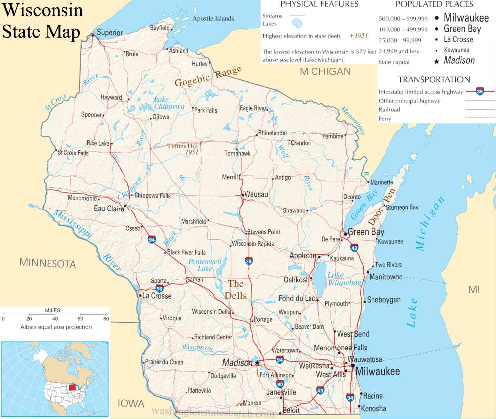
from the National Atlas of the United States
United States Department of the Interior
Wisconsin State Map
Explore Wisconsin with an interactive map featuring Street View, satellite and terrain views. Live weather, local news and location details for Wisconsin — plus links to detailed street maps for 899 cities and towns across the state.
Map search is available for a limited number of queries per session to manage costs. Be specific — search precisely for best results.
| State | Wisconsin (WI) |
| Capital | Madison |
| Largest City | Milwaukee |
| Country | United States |
| Latitude | 44.268543 |
| Longitude | -89.616508 |
| Population | 5,893,718 |
| Cities & Towns | 899 |
Wisconsin presents a landscape defined by the heavy, patient work of ice. To the south and east, the land flattens into productive plains that drink from the vast, slate-colored expanse of Lake Michigan, while the northern reaches ascend into dense, resinous forests that catch the sharp breath of Lake Superior. In the southwestern corner, the Driftless region defies this glacial history; it is a jagged, steep-walled country where water has spent eons carving deep limestone coulees that hold shadows long after the sun has retreated from the plateaus. The air here carries a distinct weight, smelling of damp cedar and river silt, and the horizon is often sliced by the sharp, vertical lines of pine stands that seem to hold the sky in place.
Indigenous nations—the Ho-Chunk, Menominee, Ojibwe, Potawatomi, and others—have moved through these river valleys and lake shores for centuries, maintaining a deep, seasonal alignment with the land long before the arrival of French fur traders and later waves of European settlers. Wisconsin emerged as a territory and then a state through the friction of these transitions, as lead miners burrowed into the earth and timber barons cleared the northern canopy to feed a growing nation. The character of the state was hardened in these early encounters, forged by the immigrant families who brought the architecture of their homelands—the sturdy brick of the Rhine or the timber craftsmanship of the fjords—to the edges of the wild, creating a mosaic of settlements that remain grounded in the stubborn, individualistic spirit of those who first broke the soil.
Industry and agriculture define the working life of the state, shifting from the massive extraction of iron and pine to a modern economy rooted in sophisticated manufacturing and agricultural stewardship. Wisconsin remains a primary theater of dairy production, where the morning light catches the white silos and the geometric patterns of fields that stretch to the edge of the woods. The rhythm of the work day is dictated by the seasons, whether it is the frantic pace of the harvest or the quieter, more calculated labor of the machine shops that produce engines and paper. There is a sense of pride in this output, a quiet acknowledgement that the goods leaving the state—from refined steel to processed cheese—are the result of a long, disciplined familiarity with one’s own hands and the specific demands of the climate.
Cultural life in Wisconsin is lived out in the dim, wood-paneled warmth of supper clubs and the boisterous, collective devotion found in stadium bleachers. On a Friday night, the scent of deep-fried perch and the clatter of silverware against heavy ceramic plates create a ritual that persists regardless of the weather, a communal anchor against the long winters. Literature and music here often mirror the landscape, favoring a stark, honest tone that avoids artifice, reflecting a people who prefer the truth of a harsh season to the comfort of a lie. Whether it is the low, steady hum of a community gathering or the sudden, sharp roar of a crowd during a game, the voice of the state is one that values consistency and a certain rugged, unassuming endurance, shaped by the biting cold and the sudden, brilliant green of a northern summer.
Wisconsin City and Town Maps
A
B
C
D
E
F
G
H
I
J
K
L
M
N
O
P
R
S
T
U
V
W
Z
Wisconsin Maps — Interactive Map, Street View, Weather & News
This page provides an interactive Google map of Wisconsin (WI) with Street View, satellite and terrain views, alongside links to detailed street maps for 899 cities and towns across the state. The state capital is Madison and the largest city is Milwaukee, with a state population of approximately 5,893,718.
Each city and town map page includes an embedded street and satellite map. Live weather where available combines National Weather Service forecasts with Open-Meteo graphical data including hourly and 7-day outlooks. Local and world news, Wikipedia location summaries, and precise GPS coordinates are included where available.
Location data is sourced from the USGS GNIS database and verified by coordinates, not name matching alone.
