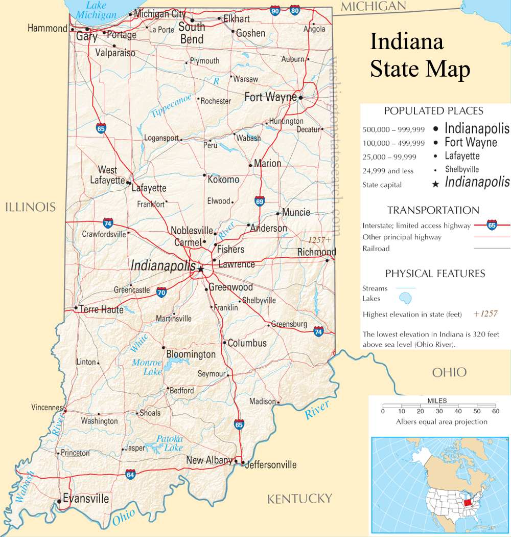
A large detailed map of Indiana State
This is a large, detailed map of Indiana. There are links to many Indiana localities below.
View our Indiana State county map
from the National Atlas of the United States
United States Department of the Interior
Indiana State Map
Explore Indiana with an interactive map featuring Street View, satellite and terrain views. Live weather, local news and location details for Indiana — plus links to detailed street maps for 987 cities and towns across the state.
Map search is available for a limited number of queries per session to manage costs. Be specific — search precisely for best results.
| State | Indiana (IN) |
| Capital | Indianapolis |
| Largest City | Indianapolis |
| Country | United States |
| Latitude | 39.9583 |
| Longitude | -86.2605 |
| Population | 6,785,528 |
| Cities & Towns | 987 |
About Indiana
Indiana's heartland unfolds in a gentle tapestry of rolling plains and fertile valleys, a landscape shaped by ancient glaciers. The land itself is a study in subtle contours, where broad rivers like the Wabash and White carve meandering paths through the rich soil, their waters reflecting the vast, often cloud-strewn skies. While the state lacks dramatic mountain ranges, its topography is punctuated by the occasional moraine and the quiet beauty of state forests and parks, such as Brown County State Park, offering glimpses of wooded hills and peaceful waterways. The climate here is one of distinct seasons, from the crisp chill of winter to the warm, humid embrace of summer, fostering a vibrant agricultural rhythm across Indiana.
The story of Indiana is one of deep roots and evolving traditions, stretching back to the Indigenous peoples who first called this land home. European settlement, primarily by those seeking fertile ground and new opportunities, gradually transformed the wilderness into farms and villages. Indiana officially became the nineteenth state in 1816, a pivotal moment that set its course toward a distinct identity. Over generations, the state has welcomed diverse peoples, each contributing to the rich mosaic of its communities and shaping the character of Indiana as it is recognized today. This continuous flow of people and ideas has woven a complex and enduring narrative.
The economic engine of Indiana hums with a diverse array of industries, its strength rooted in both the earth and the factory floor. Agriculture remains a cornerstone, with vast fields producing corn, soybeans, and other vital crops that feed the nation. Manufacturing, particularly in the automotive and steel sectors, has long been a defining feature of Indiana's industrial landscape, supporting numerous jobs and driving innovation. Beyond these traditional pillars, the state is also fostering growth in logistics, life sciences, and advanced manufacturing, with major cities like Indianapolis and Fort Wayne serving as vibrant hubs for commerce and enterprise.
The spirit of Indiana is often found in its passionate embrace of sport and its commitment to community traditions. College basketball, in particular, holds a revered place in the state's cultural fabric, fostering fierce rivalries and fervent fan bases that echo through the arenas. Professional sports also capture the attention of Hoosiers, with dedicated followings for the Indianapolis Colts in the NFL and the Indiana Pacers in the NBA. Annual events, from the iconic Indianapolis 500 race to county fairs that celebrate local harvest, bring people together, while the straightforward charm of daily life in Indiana's neighborhoods offers a comforting sense of belonging.
Indiana City and Town Maps
A
B
C
D
E
F
G
H
I
J
K
L
M
N
O
P
Q
R
S
T
U
V
W
Y
Z
Indiana Maps — Interactive Map, Street View, Weather & News
This page provides an interactive Google map of Indiana (IN) with Street View, satellite and terrain views, alongside links to detailed street maps for 987 cities and towns across the state. The state capital is Indianapolis and the largest city is Indianapolis, with a state population of approximately 6,785,528.
Each city and town map page includes an embedded street and satellite map. Live weather where available combines National Weather Service forecasts with Open-Meteo graphical data including hourly and 7-day outlooks. Local and world news, Wikipedia location summaries, and precise GPS coordinates are included where available.
Location data is sourced from the USGS GNIS database and verified by coordinates, not name matching alone.