A large detailed map of Indiana State Counties
Explore Indiana with an interactive map featuring Street View, satellite and terrain views. Browse all 92 counties of Indiana below, with links to every city and town map page. Live weather and local news are included on every location page.
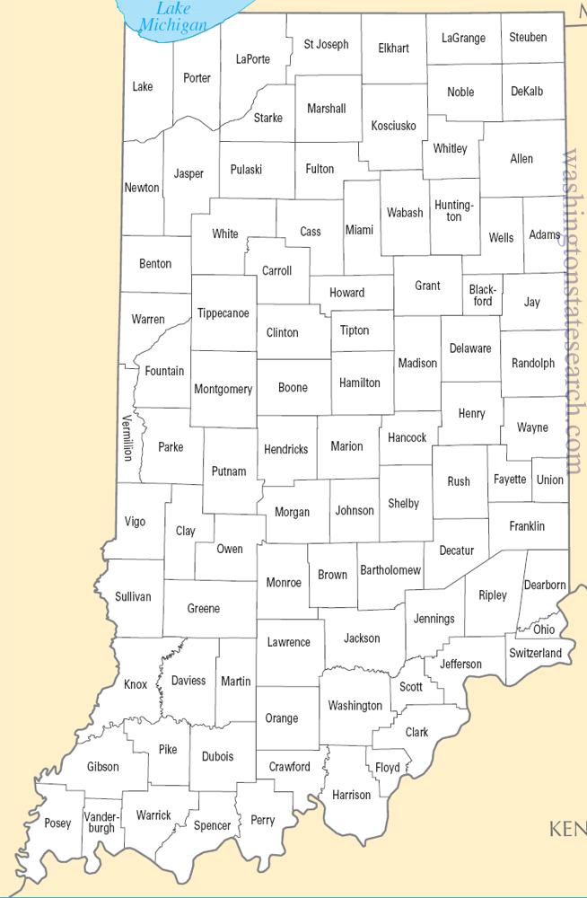
from the National Atlas of the United States
United States Department of the Interior
Indiana State Map
Map search is available for a limited number of queries per session to manage costs. Be specific — search precisely for best results.
| State | Indiana |
| Capital | Indianapolis |
| Country | United States of America |
| Counties | 92 |
| Latitude | 39.849426 |
| Longitude | -86.258278 |
| Cities & Towns | 987 |
| State Map | Indiana Maps |
About Indiana
Indiana defines itself through a glacial legacy that flattened the northern reaches into a vast, fertile plain while leaving the southern half to fracture into rugged, limestone-ribbed ridges. To the north, the land meets Lake Michigan with a sudden, wild defiance, where shifting sand dunes rise against the gray expanse of water and the hulking silhouettes of steel mills. Moving southward, the terrain softens into a mosaic of woodlots and black-soil fields, punctuated by the slow, steady progress of the Wabash and White Rivers. In the deep south, the topography gains a sharper edge, where the Ohio River carves a boundary against the hills, and the light at dusk catches the pale, porous stone of the quarries, turning the earth a bruised, luminous silver that feels older than the maps suggest.
Indigenous nations, including the Miami, Potawatomi, and Delaware, moved through these river valleys for generations, leaving a legacy of trail systems that modern roads still shadow. European influence arrived first through the French fur trade, followed by a steady push of settlers who arrived by flatboat or wagon, seeking the promise of self-sufficiency. Indiana transitioned into statehood during a time of intense territorial friction, shaped by the push to clear the dense forests and drain the marshy prairies for the plow. This era of transformation established a baseline of independence, where the necessity of survival in a raw, changing landscape fostered a skepticism of outside authority and a deep, quiet loyalty to the local clearing or the family farm.
Industry and agriculture operate here as twin pulses, often beating in the same space. The state remains a primary engine for corn and soybean harvests, where the horizon is defined by the rigid geometry of rows and the towering geometry of grain elevators that stand like sentinels against the sky. Beyond the fields, Indiana maintains a heavy, muscular industrial identity, rooted in the production of automotive parts, pharmaceutical research, and the refined output of its mills. The air in these industrial corridors often carries the metallic, ozone scent of labor, a sharp contrast to the damp, loamy smell of the fields after a spring rain. This dual economy has forced a pragmatic flexibility upon the people, who have learned to pivot between the seasonal rhythms of the harvest and the relentless, clock-driven demands of the factory floor.
Hoosier identity finds its most vocal expression in the shared fervor for basketball, a sport that functions less as a pastime and more as a winter religion in towns where the high school gymnasium is the largest, most brightly lit building for miles. This devotion is mirrored in a literary tradition that favors the vernacular, capturing the dry wit and plainspoken wisdom of people who prefer observation to grandiosity. Music, from the early influence of jazz and blues along the river to the folk traditions of the interior, retains a rhythmic, grounded quality that matches the slow, deliberate pace of life. On a quiet evening, when the heat of the day lifts from the asphalt and the crickets begin their steady, metallic drone, one can sense the state’s character: a blend of persistent labor, a love for the local team, and a fundamental comfort in the unadorned reality of the Midwestern plains.
Indiana Cities and Towns by County
Allen County
Bartholomew County
Boone County
Carroll County
Cass County
Clark County
Clay County
Clinton County
Daviess County
Dearborn County
Decatur County
Dubois County
Fountain County
Franklin County
Gibson County
Greene County
Hamilton County
Hancock County
Harrison County
Hendricks County
Henry County
Jennings County
Johnson County
Knox County
Kosciusko County
LaGrange County
LaPorte County
Lake County
Lawrence County
Madison County
Marion County
Miami County
Montgomery County
Morgan County
Newton County
Porter County
Posey County
Putnam County
Randolph County
Ripley County
Shelby County
Spencer County
St. Joseph County
Steuben County
Tippecanoe County
Vermillion County
Vigo County
Wabash County
Warren County
Washington County
Wayne County
Wells County
White County
Indiana County Maps & Location Information
This page provides an interactive Google map of Indiana (IN) with Street View, satellite and terrain views, alongside links to detailed street maps for all 987 cities and towns across the state organised by county. Indiana has 92 counties, with the state capital at Indianapolis.
Every locality page includes an embedded street and satellite map alongside live weather where available — combining National Weather Service forecasts with Open-Meteo graphical data including hourly observations and 7-day outlooks. Local and world news feeds, Wikipedia summaries and editorially written descriptions are included where available.
Location data is sourced from the USGS GNIS database and the SimpleMaps US Cities dataset, verified by coordinates rather than name matching alone.
