A large detailed map of Missouri State Counties
Explore Missouri with an interactive map featuring Street View, satellite and terrain views. Browse all 115 counties of Missouri below, with links to every city and town map page. Live weather and local news are included on every location page.
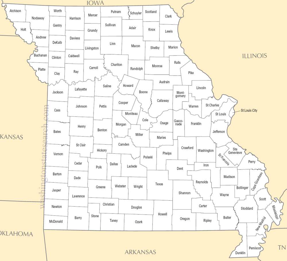
from the National Atlas of the United States
United States Department of the Interior
Missouri State Map
Map search is available for a limited number of queries per session to manage costs. Be specific — search precisely for best results.
| State | Missouri |
| Capital | Jefferson City |
| Country | United States of America |
| Counties | 115 |
| Latitude | 38.456085 |
| Longitude | -92.288368 |
| Cities & Towns | 1,109 |
| State Map | Missouri Maps |
About Missouri
Missouri spreads across the mid-continent as a transition between the flat, wind-swept prairie and the ancient, brooding uplift of the Ozark plateau. To the north, the land levels into heavy, black-soil fields that hold the heat of the sun long after the day has faded, while the southern reach rises into limestone bluffs and deep, narrow hollows where the air stays cool and damp even in mid-July. Two massive, silty rivers exert a gravitational pull on the geography, meeting in a confluence that has defined the movement of everything from sediment to commerce for millennia. In the deep woods of the south, the light filters through oak and hickory in a way that turns the atmosphere a bruised, quiet violet at dusk, emphasizing the stillness of the karst springs that bubble up from the dark, subterranean veins of the earth.
Indigenous nations, including the Osage and Missouria, navigated these waterways long before the arrival of French fur traders who established the early outposts that would eventually anchor the state. Missouri became a volatile frontier following its admission to the Union, serving as a bitter crucible during the conflict that fractured the nation in the nineteenth century. Families were often split by loyalties that mirrored the irregular topography, with skirmishes occurring in nearly every county. This period left a residue of caution in the public temperament, a lingering skepticism that prefers to see the proof of a thing before believing it. The architecture of these older settlements—brick warehouses and narrow, steep-roofed dwellings—retains the sturdy, unpretentious weight of the European immigrants who arrived later, bringing with them traditions that hardened into the state’s distinct, practical identity.
Agriculture remains the foundational rhythm of the land, though the focus has shifted from the labor-intensive crops of the past to vast, mechanized fields of soy and corn that stretch toward the horizon in precise, geometric lines. Beyond the farms, the economy has long been anchored by the production of heavy machinery, aerospace components, and the logistics of a river-based transit network. This industrial heritage gives the state a utilitarian edge; there is a preference for tools that work and structures that endure. In the quiet industrial corridors, the smell of cooling metal and wet concrete often hangs in the air, a reminder of a manufacturing legacy that continues to shift and adapt. It is a place where the labor of the hands is still accorded a quiet dignity, and the seasonal cycle of planting and harvest still dictates the urgency of the calendar for many who live away from the urban centers.
Missouri maintains a cultural tempo that is neither hurried nor stagnant, favoring a measured, plain-spoken directness in its literature and daily discourse. The regional appetite is defined by a deep affinity for slow-smoked meats and a culinary heritage that blends the hearty traditions of the Midwest with the more robust flavors of the South. Collegiate and professional sports provide a common language, drawing massive crowds that fill stadiums with a fervor that can briefly unify a divided population. Whether in the jazz-infused streets of the western border or the river-front neighborhoods of the east, the state possesses a specific, grounded voice that is wary of affectation. On summer evenings, when the humidity settles over the plains and the cicadas begin their rhythmic drone, the atmosphere feels dense with a sense of place that is entirely its own, rooted in the hard, honest work of making a life in the middle of the continent.
Missouri Cities and Towns by County
Barry County
Boone County
Buchanan County
Cape Girardeau County
Cass County
Chariton County
Clay County
Cooper County
Daviess County
Franklin County
Greene County
Jackson County
Jasper County
Jefferson County
Johnson County
Lafayette County
Lawrence County
Lincoln County
Linn County
McDonald County
Miller County
Montgomery County
New Madrid County
Newton County
Ozark County
Pemiscot County
Phelps County
Pike County
Platte County
Polk County
Ray County
Saline County
Scott County
St. Francois County
St. Louis County
Ste. Genevieve County
Stone County
Taney County
Vernon County
Missouri County Maps & Location Information
This page provides an interactive Google map of Missouri (MO) with Street View, satellite and terrain views, alongside links to detailed street maps for all 1,109 cities and towns across the state organised by county. Missouri has 115 counties, with the state capital at Jefferson City.
Every locality page includes an embedded street and satellite map alongside live weather where available — combining National Weather Service forecasts with Open-Meteo graphical data including hourly observations and 7-day outlooks. Local and world news feeds, Wikipedia summaries and editorially written descriptions are included where available.
Location data is sourced from the USGS GNIS database and the SimpleMaps US Cities dataset, verified by coordinates rather than name matching alone.
