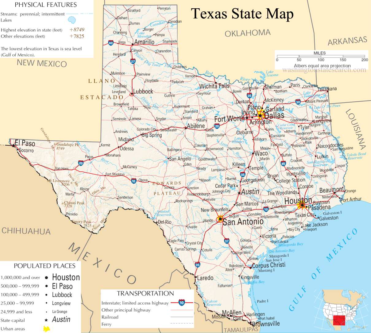
A large detailed map of Texas State
This is a large, detailed map of Texas. There are links to many Texas localities below. Our website format reduces the display size for uniformity. Here is a link to the full-size image that is more easily readable.
View our Texas State county map
from the National Atlas of the United States
United States Department of the Interior
Texas State Map
Explore Texas with an interactive map featuring Street View, satellite and terrain views. Live weather, local news and location details for Texas — plus links to detailed street maps for 2,024 cities and towns across the state.
Map search is available for a limited number of queries per session to manage costs. Be specific — search precisely for best results.
| State | Texas (TX) |
| Capital | Austin |
| Largest City | Houston |
| Country | United States |
| Latitude | 30.7277 |
| Longitude | -97.7806 |
| Population | 29,145,505 |
| Cities & Towns | 2,024 |
About Texas
Texas unfurls across a vast and varied canvas, its heartland a tapestry of rolling plains and wide-open skies that stretch towards horizons painted with the hues of dawn and dusk. To the east, the Piney Woods offer a verdant contrast, while the rugged beauty of the Edwards Plateau rises in the central regions, giving way to the stark grandeur of the Trans-Pecos desert in the west. The Gulf Coast, a ribbon of beaches and bayous, defines its southern edge, a vital artery for trade and a sanctuary for diverse wildlife. Major rivers like the Brazos and Colorado carve their paths across the landscape, nourishing fertile valleys and shaping the very character of the land, while protected areas like Big Bend National Park showcase the wild, untamed spirit of Texas.
The story of Texas is etched in the dust of ages, a narrative beginning with ancient peoples who walked these lands for millennia, their presence now a whisper in the wind and the echoes of their lives in the earth. European explorers and settlers later arrived, drawn by the promise of opportunity and the lure of the frontier, shaping the nascent identity of this sprawling territory. Through periods of revolution and independence, Texas eventually joined the United States, its unique spirit and resilience forged in the crucible of its formative years. This rich history continues to inform the character of Texas today, a blend of enduring traditions and a forward-looking vision.
The economic engine of Texas hums with a dynamic energy, fueled by a diverse array of industries that drive its prosperity. The state remains a global powerhouse in energy production, with vast reserves of oil and natural gas continuing to shape its landscape and economy. Agriculture, too, plays a significant role, from the vast ranches of West Texas to the fertile farms of the Blackland Prairie, producing bountiful harvests. Beyond these traditional pillars, Texas has emerged as a leader in advanced manufacturing and a burgeoning hub for technology, attracting innovation and talent to its major urban centers like Houston, Dallas, and Austin.
The soul of Texas beats with a distinct rhythm, a culture that celebrates its heritage while embracing a vibrant, contemporary spirit. This is a place where Friday night lights often illuminate the passion for high school football, and professional teams in all major sports command fervent followings, from the Cowboys and Texans in the NFL to the Mavericks and Spurs in the NBA. Annual events like the State Fair of Texas draw millions, showcasing the state’s agricultural prowess and offering a taste of its iconic cuisine, a bold fusion of Tex-Mex, Southern comfort, and barbecue. The character of daily life in Texas is often defined by a sense of community, a friendly pragmatism, and an unwavering pride in its Lone Star identity.
Texas City and Town Maps
A
B
C
D
E
F
G
H
I
J
K
L
M
N
O
P
Q
R
S
T
U
V
W
Texas Maps — Interactive Map, Street View, Weather & News
This page provides an interactive Google map of Texas (TX) with Street View, satellite and terrain views, alongside links to detailed street maps for 2,024 cities and towns across the state. The state capital is Austin and the largest city is Houston, with a state population of approximately 29,145,505.
Each city and town map page includes an embedded street and satellite map. Live weather where available combines National Weather Service forecasts with Open-Meteo graphical data including hourly and 7-day outlooks. Local and world news, Wikipedia location summaries, and precise GPS coordinates are included where available.
Location data is sourced from the USGS GNIS database and verified by coordinates, not name matching alone.