A large detailed map of Illinois State Counties
Explore Illinois with an interactive map featuring Street View, satellite and terrain views. Browse all 102 counties of Illinois below, with links to every city and town map page. Live weather and local news are included on every location page.
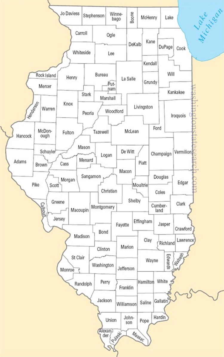
from the National Atlas of the United States
United States Department of the Interior
Illinois State Map
Map search is available for a limited number of queries per session to manage costs. Be specific — search precisely for best results.
| State | Illinois |
| Capital | Springfield |
| Country | United States of America |
| Counties | 102 |
| Latitude | 40.349457 |
| Longitude | -88.986137 |
| Cities & Towns | 1,513 |
| State Map | Illinois Maps |
About Illinois
Illinois extends across a vast, flattened expanse that serves as a bridge between the Great Lakes and the lower Mississippi valley. Its topography is defined by the glacier-scoured plains that drop away from the blue, cold reach of Lake Michigan, flowing toward the silty, serpentine currents of the Illinois and Ohio rivers. These waterways carve the state into distinct zones, ranging from the jagged, unglaciated limestone bluffs of the south to the immense, horizon-bound flatness of the central prairie. When the sun hangs low over these open fields, the light stretches thin and amber, catching the dust of the dry stalks and turning the entire landscape into a muted, glowing bronze. There is a persistent, elemental weight to the land here, a sense that the horizon is not merely a boundary but a wide-open invitation to movement.
Indigenous nations, including the Illiniwek and later the Potawatomi, long occupied these river valleys before the arrival of French explorers and the subsequent tide of settlers pushed west. The state emerged from the frontier, defined by a hard-won transition from a territory of fur traders and outposts to a pivotal center of nineteenth-century expansion. This was the landscape of Lincoln, a place of wood-framed courthouses and rail-split fences where the rhetoric of a fractured nation was first forged. The history of Illinois is marked by the relentless drive of the railroad, which transformed remote trading posts into hubs of iron and industry, binding the frontier to the coastal markets. One can still perceive, in the sturdy brick facades of older towns, the stubborn ambition of those who arrived to carve a civilization out of the tallgrass.
Agriculture and heavy industry define the productive life of the state, creating a dual economy that balances the mechanical precision of the factory with the seasonal labor of the field. Vast stretches of corn and soybeans operate with the rhythmic regularity of a clock, feeding into global networks that rely on the state’s massive logistics of rail, barge, and truck. Historically, the output of these fertile acres provided the raw materials for a manufacturing powerhouse, fueling the growth of meatpacking, steel, and machinery production. The air in these industrial corridors often carries the faint, sharp metallic scent of cooling iron, a reminder of the thousands of hands that have labored to keep the machinery of the nation in motion. It is a pragmatic existence, where the value of a day is measured by the tangible weight of what has been built or harvested.
Cultural character in Illinois is a study in contrasts, oscillating between the dense, vertical intensity of its primary metropolis and the quiet, deliberate pace of the rural interior. The local identity is shaped by a deep-seated devotion to collegiate and professional sport, where the outcome of a game can settle the mood of an entire neighborhood for a week. Music here—from the electric blues that rose out of the urban migration to the folk traditions of the river towns—carries a gritty, honest frequency. The food is equally unpretentious, favoring hearty, sustaining fare that reflects the diverse ethnic threads of its immigrant populations. Whether navigating the rigid, wind-whipped geometry of a city street or sitting on a porch as the crickets begin their evening chorus, the people possess a grounded, straightforward manner that prioritizes endurance over artifice.
Illinois Cities and Towns by County
Adams County
Alexander County
Christian County
Clinton County
Cook County
DuPage County
Fayette County
Franklin County
Fulton County
Grundy County
Iroquois County
Jackson County
Jefferson County
Jo Daviess County
Johnson County
Kane County
Kankakee County
Kendall County
Knox County
LaSalle County
Lake County
Lee County
Logan County
Macon County
Macoupin County
Madison County
Mason County
McDonough County
McHenry County
McLean County
Mercer County
Montgomery County
Morgan County
Ogle County
Peoria County
Piatt County
Pike County
Randolph County
Rock Island County
Sangamon County
Shelby County
St. Clair County
Stephenson County
Tazewell County
Wayne County
White County
Whiteside County
Will County
Williamson County
Winnebago County
Woodford County
Illinois County Maps & Location Information
This page provides an interactive Google map of Illinois (IL) with Street View, satellite and terrain views, alongside links to detailed street maps for all 1,513 cities and towns across the state organised by county. Illinois has 102 counties, with the state capital at Springfield.
Every locality page includes an embedded street and satellite map alongside live weather where available — combining National Weather Service forecasts with Open-Meteo graphical data including hourly observations and 7-day outlooks. Local and world news feeds, Wikipedia summaries and editorially written descriptions are included where available.
Location data is sourced from the USGS GNIS database and the SimpleMaps US Cities dataset, verified by coordinates rather than name matching alone.
